FAA INFORMATION EFFECTIVE 19 MARCH 2026
Location
| FAA Identifier: | MPI |
| Lat/Long: | 37-30-39.1000N 120-02-22.3000W
37-30.651667N 120-02.371667W
37.5108611,-120.0395278
(estimated) |
| Elevation: | 2254.2 ft. / 687.1 m (surveyed) |
| Variation: | 15E (1985) |
| From city: | 4 miles W of MARIPOSA, CA |
| Time zone: | UTC -7 (UTC -8 during Standard Time) |
| Zip code: | 95338 |
Airport Operations
| Airport use: | Open to the public |
| Activation date: | 04/1940 |
| Control tower: | no |
| ARTCC: | OAKLAND CENTER |
| FSS: | RANCHO MURIETA FLIGHT SERVICE STATION |
| NOTAMs facility: | RIU (NOTAM-D service available) |
| Attendance: | MON-FRI 1000-1600 |
| Wind indicator: | lighted |
| Segmented circle: | yes |
| Lights: | ACTVT PAPI RWY 08 & 26; MIRL RWY 08/26 - CTAF. |
| Beacon: | white-green (lighted land airport)
Operates sunset to sunrise. |
Airport Communications
| CTAF/UNICOM: | 122.7 |
| WX AWOS-3: | 135.6 (209-966-2912) |
- APCH/DEP CTL SVC PRVDD BY OAKLAND ARTCC (ZOA) ON FREQ 121.25/327.0 (ANGELS CAMP RCAG).
Nearby radio navigation aids
| VOR radial/distance | | VOR name | | Freq | | Var |
|---|
| HYPr030/24.5 | | EL NIDO VOR/DME | | 113.85 | | 15E |
| FRAr302/32.3 | | FRIANT VORTAC | | 115.60 | | 17E |
Airport Services
| Fuel available: | 100LL JET-A
100LL:FUEL AVBL 24 HRS WITH CREDIT CARD. |
| Parking: | tiedowns |
| Airframe service: | MINOR |
| Powerplant service: | MINOR |
| Bottled oxygen: | NONE |
| Bulk oxygen: | NONE |
Runway Information
Runway 8/26
| Dimensions: | 3305 x 60 ft. / 1007 x 18 m |
| Surface: | asphalt, in poor condition
UNSEALED MED TO HIGH SVRTY LONGL AND LATERAL CRACKS IN THE ASPH PAVEMENT EXTD THE ENTIRE LEN OF RWY 8/26 WITH SOME LOOSE DEBRIS FOUND SCATTERED ACRS THE SFC. |
| Weight bearing capacity: | |
| Runway edge lights: | medium intensity |
| RUNWAY 8 | | RUNWAY 26 |
| Latitude: | 37-30.698043N | | 37-30.606395N |
| Longitude: | 120-02.709322W | | 120-02.035483W |
| Elevation: | 2254.2 ft. | | 2222.9 ft. |
| Traffic pattern: | right | | left |
| Runway heading: | 085 magnetic, 100 true | | 265 magnetic, 280 true |
| Markings: | nonprecision, in fair condition | | nonprecision, in fair condition |
| Visual slope indicator: | 2-light PAPI on left (4.00 degrees glide path) | | 2-light PAPI on left (4.50 degrees glide path) |
| Runway end identifier lights: | no | | no |
| Touchdown point: | yes, no lights | | yes, no lights |
| Obstructions: | 45 ft. tree, 1340 ft. from runway, 130 ft. right of centerline, 25:1 slope to clear | | 29 ft. tree, 762 ft. from runway, 83 ft. left of centerline, 20:1 slope to clear |
Airport Ownership and Management from official FAA records
| Ownership: | Publicly-owned |
| Owner: | COUNTY OF MARIPOSA
4639 BEN HUR ROAD
MARIPOSA, CA 95338
Phone 209-966-5356 |
| Manager: | SAMUEL CERVENY
4639 BEN HUR ROAD
MARIPOSA, CA 95338
Phone 209-966-5356 |
Additional Remarks
| - | TRANSITIONAL SURFACE OBSTRUCTION: MOUNTAINS TO NORTH OF RWY 08/26. |
| - | RY 08 TERRAIN DROPS ALONG BOTH SIDES OF TWY 45 FT FM RY EDGE. |
| - | BIRDS ON AND INVOF ARPT. |
| - | FOR CD CTC OAKLAND ARTCC AT 510-745-3380. |
Instrument Procedures
NOTE: All procedures below are presented as PDF files. If you need a reader for these files, you should download the free Adobe Reader.NOT FOR NAVIGATION. Please procure official charts for flight.
FAA instrument procedures published for use from 19 March 2026 at 0901Z to 16 April 2026 at 0900Z.
IAPs - Instrument Approach Procedures |
|---|
| RNAV (GPS)-A | |
download (275KB) |
| RNAV (GPS)-B | |
download (292KB) |
| NOTE: Special Alternate Minimums apply | |
download (140KB) |
| NOTE: Special Alternate Minimums apply | |
download (140KB) |
| NOTE: Special Take-Off Minimums/Departure Procedures apply | |
download (128KB) |
Other nearby airports with instrument procedures:
E45 - Pine Mountain Lake Airport (22 nm N)
KMCE - Merced Yosemite Regional Airport (26 nm SW)
KMER - Castle Airport (26 nm W)
O15 - Turlock Municipal Airport (31 nm W)
KMAE - Madera Municipal Airport (32 nm S)
|
|

Road maps at:
MapQuest
Bing
Google
| Aerial photo |
|---|
WARNING: Photo may not be current or correct
 Photo by David Newcomer
Photo taken 27-Oct-2014
from 2,000 AGL looking northeast.
Photo by David Newcomer
Photo taken 27-Oct-2014
from 2,000 AGL looking northeast.
Do you have a better or more recent aerial photo of Mariposa-Yosemite Airport that you would like to share? If so, please send us your photo.
|
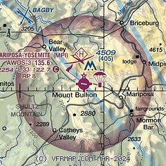
| Sectional chart |
|---|
|
| Airport distance calculator |
|---|
|
|
| Sunrise and sunset |
|---|
|
Times for 14-Apr-2026
| | Local
(UTC-7) | | Zulu
(UTC) |
|---|
| Morning civil twilight | | 06:01 | | 13:01 |
| Sunrise | | 06:28 | | 13:28 |
| Sunset | | 19:33 | | 02:33 |
| Evening civil twilight | | 20:00 | | 03:00 |
|
| Current date and time |
|---|
| Zulu (UTC) | 15-Apr-2026 01:23:35 |
|---|
| Local (UTC-7) | 14-Apr-2026 18:23:35 |
|---|
|
| METAR |
|---|
KMCE
26nm SW | 150053Z AUTO 33009KT 10SM CLR 22/07 A3007 RMK AO2 SLP182 T02170067
|
KMER
26nm W | 150055Z 36010KT 10SM CLR
|
KMAE
32nm S | 150053Z AUTO 32008KT 10SM CLR 22/05 A3007 RMK AO2 SLP183 T02170050
|
KO22
36nm NW | 150055Z AUTO 28008KT 10SM FEW040 17/07 A3011 RMK A01 P0001
|
KMOD
44nm W | 150053Z 30013KT 10SM CLR 21/08 A3008 RMK AO2 SLP185 T02060083
|
KFAT
46nm S | 150053Z 29011KT 10SM SCT050 SCT090 SCT180 22/06 A3006 RMK AO2 SLP178 T02220056
|
KCPU
48nm NW | 150055Z AUTO 33008KT 10SM CLR 18/07 A3011 RMK AO2 T01760065
|
KFCH
49nm S | 150055Z AUTO 29011KT 10SM CLR 22/05 A3007 RMK A01
|
|
| TAF |
|---|
KMCE
26nm SW | 141720Z 1418/1518 VRB05KT P6SM SKC
|
KMER
26nm W | 141720Z 1418/1518 VRB05KT P6SM SKC AMD NOT SKED
|
|
| NOTAMs |
|---|
NOTAMs are issued by the DoD/FAA and will open in a separate window not controlled by AirNav.
|
|

