FAA INFORMATION EFFECTIVE 19 FEBRUARY 2026
Location
| FAA Identifier: | MPR |
| Lat/Long: | 38-21-08.6170N 097-41-28.6740W
38-21.143617N 097-41.477900W
38.3523936,-97.6912983
(estimated) |
| Elevation: | 1498.3 ft. / 456.7 m (surveyed) |
| Variation: | 06E (2000) |
| From city: | 1 mile SW of MC PHERSON, KS |
| Time zone: | UTC -6 (UTC -5 during Daylight Saving Time) |
| Zip code: | 67460 |
Airport Operations
| Airport use: | Open to the public |
| Activation date: | 09/1946 |
| Control tower: | no |
| ARTCC: | KANSAS CITY CENTER |
| FSS: | WICHITA FLIGHT SERVICE STATION |
| NOTAMs facility: | ICT (NOTAM-D service available) |
| Attendance: | SAT 0800-1200, ALL MON-FRI 0800-1700 |
| Wind indicator: | lighted |
| Segmented circle: | yes |
| Lights: | MIRL RY 18/36 PRESET ON LOW INTST TO INCREASE INTST ACTVT - CTAF. |
| Beacon: | white-green (lighted land airport)
Operates sunset to sunrise. |
Airport Communications
| CTAF/UNICOM: | 122.8 |
| WX AWOS-3P: | 119.025 (620-798-1650) |
| WICHITA APPROACH: | 125.5 |
| WICHITA DEPARTURE: | 125.5 |
| WX ASOS at HUT (19 nm SW): | PHONE 620-662-1071 |
Nearby radio navigation aids
| VOR radial/distance | | VOR name | | Freq | | Var |
|---|
| HUTr024/24.2 | | HUTCHINSON VOR/DME | | 116.80 | | 04E |
| SLNr178/34.5 | | SALINA VORTAC | | 117.10 | | 07E |
| ICTr345/36.8 | | WICHITA VORTAC | | 113.80 | | 07E |
Airport Services
| Fuel available: | 100LL JET-A MOGAS
100LL:100LL IS AVBL BY USE OF CREDIT CARD. JET A AND MO GAS AFTER HOURS CALL MANAGER 620-755-8901 |
| Parking: | hangars and tiedowns |
| Airframe service: | MAJOR |
| Powerplant service: | MAJOR |
| Bottled oxygen: | NONE |
| Bulk oxygen: | NONE |
Runway Information
Runway 18/36
| Dimensions: | 5503 x 100 ft. / 1677 x 30 m |
| Surface: | concrete, in good condition
PORTIONS OF TWYS & TIE DOWN AREAS ARE A COMBINATION OF CONCRETE & ASPHALT. |
| Weight bearing capacity: | | PCN 11 /R/C/X/U | | Single wheel: | 30.0 |
|
| Runway edge lights: | medium intensity |
| RUNWAY 18 | | RUNWAY 36 |
| Latitude: | 38-21.527225N | | 38-20.625053N |
| Longitude: | 097-41.338205W | | 097-41.450425W |
| Elevation: | 1493.8 ft. | | 1494.8 ft. |
| Traffic pattern: | right | | left |
| Runway heading: | 180 magnetic, 186 true | | 000 magnetic, 006 true |
| Markings: | nonprecision, in fair condition | | nonprecision, in fair condition |
| Visual slope indicator: | 4-light PAPI on left (3.00 degrees glide path) | | 4-light PAPI on left (3.00 degrees glide path) |
| Runway end identifier lights: | yes | | yes |
| Touchdown point: | yes, no lights | | yes, no lights |
Runway 8/26
| Dimensions: | 2502 x 75 ft. / 763 x 23 m |
| Surface: | turf, in good condition |
| Runway edge markings: | RWY 26 THLD AND EDGE DELINEATED WITH YELLOW CONES. |
| RUNWAY 8 | | RUNWAY 26 |
| Latitude: | 38-21.290378N | | 38-21.293625N |
| Longitude: | 097-41.923417W | | 097-41.400030W |
| Elevation: | 1494.1 ft. | | 1493.2 ft. |
| Traffic pattern: | left | | right |
| Runway heading: | 084 magnetic, 090 true | | 264 magnetic, 270 true |
| Markings: | , in good condition | | , in good condition |
| Runway end identifier lights: | no | | no |
| Touchdown point: | yes, no lights | | yes, no lights |
Airport Ownership and Management from official FAA records
| Ownership: | Publicly-owned |
| Owner: | COUNTY & CITY OF MC PHERSON
400 EAST KANSAS
MC PHERSON, KS 67460
Phone (620) 245-2535 |
| Manager: | CYNTHIA PETERSON
1000 S. 81 BYPASS
MC PHERSON, KS 67460
Phone 620-241-0684 |
Additional Remarks
| - | PHONE AVBL 24 HRS. |
| - | +300 FOOT CONSTRUCTION CRANES OCCASIONALLY AT REFINERY .9 MILES EAST SOUTHEAST OF AIRPORT |
| - | AWOS (620) 241-2498 FREQ. 119.025 |
| - | FOR CD IF UNA TO CTC ON FSS FREQ, CTC WICHITA APPCH AT 316-350-1520 |
Instrument Procedures
NOTE: All procedures below are presented as PDF files. If you need a reader for these files, you should download the free Adobe Reader.NOT FOR NAVIGATION. Please procure official charts for flight.
FAA instrument procedures published for use from 19 February 2026 at 0901Z to 19 March 2026 at 0900Z.
IAPs - Instrument Approach Procedures |
|---|
| RNAV (GPS) RWY 18 | |
download (248KB) |
| RNAV (GPS) RWY 36 | |
download (256KB) |
| VOR RWY 36 | |
download (209KB) |
| NOTE: Special Take-Off Minimums/Departure Procedures apply | |
download (358KB) |
Other nearby airports with instrument procedures:
47K - Moundridge Municipal Airport (12 nm SE)
KHUT - Hutchinson Regional Airport (19 nm SW)
KLYO - Lyons-Rice County Municipal Airport (25 nm W)
KSLN - Salina Regional Airport (26 nm N)
KEWK - Newton City/County Airport (26 nm SE)
|
|

Road maps at:
MapQuest
Bing
Google
| Aerial photo |
|---|
WARNING: Photo may not be current or correct
 As seen circa 2006
Do you have a better or more recent aerial photo of Mc Pherson Airport that you would like to share? If so, please send us your photo.
|
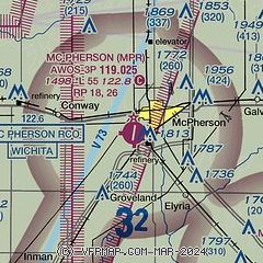
| Sectional chart |
|---|
|
| Airport distance calculator |
|---|
|
|
| Sunrise and sunset |
|---|
|
Times for 15-Mar-2026
| | Local
(UTC-5) | | Zulu
(UTC) |
|---|
| Morning civil twilight | | 07:17 | | 12:17 |
| Sunrise | | 07:43 | | 12:43 |
| Sunset | | 19:37 | | 00:37 |
| Evening civil twilight | | 20:03 | | 01:03 |
|
| Current date and time |
|---|
| Zulu (UTC) | 15-Mar-2026 13:43:59 |
|---|
| Local (UTC-5) | 15-Mar-2026 08:43:59 |
|---|
|
| METAR |
|---|
| KMPR | 151315Z AUTO 32026G39KT 10SM BKN023 05/M01 A2956 RMK AO2 T00511009
|
KHUT
19nm SW | 151252Z 32034G44KT 10SM CLR 06/M02 A2952 RMK AO2 SLP987 T00611022
|
|
| TAF |
|---|
KHUT
19nm SW | 151120Z 1512/1612 34015G24KT P6SM BKN120 FM151300 33034G45KT P6SM BKN120 TEMPO 1513/1517 5SM BLDU FM151700 34038G52KT P6SM BKN070 TEMPO 1517/1521 3SM BLDU FM160000 34026G35KT P6SM SCT220 FM160300 34018G26KT P6SM FEW200
|
|
| NOTAMs |
|---|
NOTAMs are issued by the DoD/FAA and will open in a separate window not controlled by AirNav.
|
|

