FAA INFORMATION EFFECTIVE 14 MAY 2026
Location
| FAA Identifier: | MRN |
| Lat/Long: | 35-49-12.8000N 081-36-41.1000W
35-49.213333N 081-36.685000W
35.8202222,-81.6114167
(estimated) |
| Elevation: | 1269.9 ft. / 387.1 m (surveyed) |
| Variation: | 07W (2005) |
| From city: | 6 miles NE of MORGANTON, NC |
| Time zone: | UTC -4 (UTC -5 during Standard Time) |
| Zip code: | 28655 |
Airport Operations
| Airport use: | Open to the public |
| Activation date: | 12/1945 |
| Control tower: | no |
| ARTCC: | ATLANTA CENTER |
| FSS: | RALEIGH FLIGHT SERVICE STATION |
| NOTAMs facility: | MRN (NOTAM-D service available) |
| Attendance: | MON-SAT 0800-1700, ALL SUN 0900-1700 |
| Wind indicator: | lighted |
| Segmented circle: | yes |
| Lights: | ACTVT REILS RWY 03 & 21; PAPI RWY 03 & 21; MIRL RWY 03/21 - CTAF. |
| Beacon: | white-green (lighted land airport)
Operates sunset to sunrise. |
Airport Communications
| CTAF/UNICOM: | 122.7 |
| WX AWOS-3P: | 124.175 (828-757-0788) |
| WX ASOS at HKY (12 nm SE): | 118.325 (828-322-2996) |
- APCH/DEP SVC PRVDD BY ATLANTA ARTCC (ZTL) ON FREQS 125.15/263.0 (HICKORY RCAG).
Nearby radio navigation aids
| VOR radial/distance | | VOR name | | Freq | | Var |
|---|
| BZMr267/18.3 | | BARRETTS MOUNTAIN VOR/DME | | 113.75 | | 06W |
| NDB name | | Hdg/Dist | | Freq | | Var | | ID |
|---|
| FIDDLERS | | 031/7.2 | | 391 | | 07W | | FIQ | ..-. .. --.- |
| HEMLOCK | | 149/23.9 | | 320 | | 02W | | BAR | -... .- .-. |
Airport Services
| Fuel available: | 100LL JET-A1+
100LL:AFTER HOURS FUEL OR SERVICE CALL 828-757-0099 |
| Parking: | tiedowns |
| Airframe service: | MAJOR |
| Powerplant service: | MAJOR |
| Bottled oxygen: | LOW |
| Bulk oxygen: | HIGH |
Runway Information
Runway 3/21
| Dimensions: | 5500 x 75 ft. / 1676 x 23 m |
| Surface: | asphalt, in good condition |
| Weight bearing capacity: | |
| Runway edge lights: | medium intensity |
| RUNWAY 3 | | RUNWAY 21 |
| Latitude: | 35-48.798718N | | 35-49.629208N |
| Longitude: | 081-36.907490W | | 081-36.461812W |
| Elevation: | 1230.2 ft. | | 1269.7 ft. |
| Traffic pattern: | left | | left |
| Runway heading: | 031 magnetic, 024 true | | 211 magnetic, 204 true |
| Markings: | nonprecision, in good condition | | nonprecision, in good condition |
| Visual slope indicator: | 4-light PAPI on left (3.00 degrees glide path) | | 4-light PAPI on right (3.50 degrees glide path) |
| Runway end identifier lights: | yes | | yes |
| Touchdown point: | yes, no lights | | yes, no lights |
| Instrument approach: | LOCALIZER | | |
| Obstructions: | 10 ft. trees, 612 ft. from runway, 306 ft. left of centerline, 41:1 slope to clear | | 16 ft. trees, 548 ft. from runway, 237 ft. left of centerline, 21:1 slope to clear |
Airport Ownership and Management from official FAA records
| Ownership: | Publicly-owned |
| Owner: | FOOTHILLS REGIONAL AIRPORT AUTHORIT
3566 FOOTHILLS AIRPORT RD
MORGANTON, NC 28655
Phone 828-757-0099 |
| Manager: | BRENT BRINKLEY
3566 FOOTHILLS AIRPORT RD
MORGANTON, NC 28655
Phone 828-757-0099 |
Additional Remarks
| - | APRON TIE DOWN SPACE LTD. |
| - | RY 03, 100 FT DROPOFF 330 FT FM THLD AND 80 FT BOTH SIDES OF CNTRLN ALONG FIRST 1000 FT OF RY. |
| - | RY 21, 30 FT DROPOFF 400 FT FM THLD BOTH SIDES AND 10 FT DROPOFF 50 FT FM THLD AND 150 FT RIGHT OF CNTRLN. |
| - | HANG GLIDER ACT DALGT HRS - EAST SIDE OF RWY 03/21 IN RWY SAFETY AREA. |
| - | DEER & COYOTE ON & INVOF ARPT. |
| - | FOR CD CTC ATLANTA ARTCC AT 770-210-7692. |
Instrument Procedures
NOTE: All procedures below are presented as PDF files. If you need a reader for these files, you should download the free Adobe Reader.NOT FOR NAVIGATION. Please procure official charts for flight.
FAA instrument procedures published for use from 14 May 2026 at 0901Z to 11 June 2026 at 0900Z.
IAPs - Instrument Approach Procedures |
|---|
| RNAV (GPS) RWY 03 | |
download (316KB) |
| RNAV (GPS) RWY 21 **CHANGED** | |
download (323KB) |
| LOC RWY 03 | |
download (241KB) |
| NOTE: Special Alternate Minimums apply | |
download (162KB) |
| NOTE: Special Take-Off Minimums/Departure Procedures apply | |
download (141KB) |
Other nearby airports with instrument procedures:
KHKY - Hickory Regional Airport (12 nm SE)
KFQD - Rutherford County Airport/Marchman Field (28 nm SW)
KIPJ - Lincoln County Regional Airport (30 nm SE)
KSVH - Statesville Regional Airport (32 nm E)
KEHO - Shelby-Cleveland County Regional Airport (34 nm S)
|
|

Road maps at:
MapQuest
Bing
Google
| Aerial photo |
|---|
WARNING: Photo may not be current or correct

Do you have a better or more recent aerial photo of Foothills Regional Airport that you would like to share? If so, please send us your photo.
|
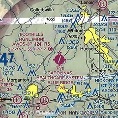
| Sectional chart |
|---|
|
| Airport distance calculator |
|---|
|
|
| Sunrise and sunset |
|---|
|
Times for 30-May-2026
| | Local
(UTC-4) | | Zulu
(UTC) |
|---|
| Morning civil twilight | | 05:44 | | 09:44 |
| Sunrise | | 06:13 | | 10:13 |
| Sunset | | 20:35 | | 00:35 |
| Evening civil twilight | | 21:04 | | 01:04 |
|
| Current date and time |
|---|
| Zulu (UTC) | 31-May-2026 00:17:03 |
|---|
| Local (UTC-4) | 30-May-2026 20:17:03 |
|---|
|
| METAR |
|---|
| KMRN | 302355Z AUTO 00000KT 10SM BKN055 23/23 A2996 RMK AO2 T02330225
|
KHKY
12nm E | 302353Z 00000KT 10SM FEW075 SCT095 24/14 A2995 RMK AO2 SLP120 60022 T02390139 10261 20211 53008
|
|
| TAF |
|---|
KHKY
12nm E | 302150Z 3022/3118 VRB03KT P6SM VCSH FEW040 BKN100 FM310000 03004KT P6SM SCT100 BKN250 FM310600 05008G16KT P6SM SCT250 FM310800 04006KT P6SM SCT250 FM311500 12004KT P6SM SCT150
|
|
| NOTAMs |
|---|
NOTAMs are issued by the DoD/FAA and will open in a separate window not controlled by AirNav.
|
|

