FAA INFORMATION EFFECTIVE 19 MARCH 2026
Location
| FAA Identifier: | MRY |
| Lat/Long: | 36-35-13.0280N 121-50-34.0190W
36-35.217133N 121-50.566983W
36.5869522,-121.8427831
(estimated) |
| Elevation: | 256.6 ft. / 78.2 m (surveyed) |
| Variation: | 15E (2000) |
| From city: | 3 miles SE of MONTEREY, CA |
| Time zone: | UTC -7 (UTC -8 during Standard Time) |
| Zip code: | 93940 |
Airport Operations
| Airport use: | Open to the public |
| Activation date: | 04/1940 |
| Control tower: | yes |
| ARTCC: | OAKLAND CENTER |
| FSS: | OAKLAND FLIGHT SERVICE STATION |
| NOTAMs facility: | MRY (NOTAM-D service available) |
| Attendance: | CONTINUOUS |
| Pattern altitude: | 1756.6 ft. MSL |
| Wind indicator: | lighted |
| Segmented circle: | yes |
| Lights: | WHEN ATCT CLSD, ACTVT MALSR RWY 10R, REIL RWY 28L, PAPI RWY 10L, 10R, 28L & 28R, HIRL RWY 10R/28L - CTAF. WHEN ATCT CLOSED REIL RWY 10L & 28R; MIRL RWY 10L/28R UNAVBL. |
| Beacon: | white-green (lighted land airport)
Operates sunset to sunrise. |
| Landing fee: | no, CTC FBO FOR RATES AND CHARGES. LNDG FEE CHARGED FOR ACFT OVER 6,000 LBS AND HELICOPTERS. OVERNIGHT TIEDOWN FEE AT FBO. |
| Fire and rescue: | ARFF index B |
| International operations: | customs landing rights airport |
Airport Communications
| CTAF: | 118.4 |
| UNICOM: | 122.95 |
| ATIS: | 119.25 |
| WX ASOS: | PHONE 831-643-6841 |
| MONTEREY GROUND: | 120.875 348.6 [0600-2100] |
| MONTEREY TOWER: | 118.4 257.8 [0600-2100] |
| NORCAL APPROACH: | 127.15 ;136-360 MRY 133.0 ;001-135 MRY |
| NORCAL DEPARTURE: | 127.15 ;136-360 MRY 133.0 ;001-135 MRY |
| CLEARANCE DELIVERY: | 135.45 |
| CLASS C: | 127.15 ;136-360 MRY 133.0 ;001-135 MRY |
| EMERG: | 121.5 243.0 |
| IC: | 127.15 ;136-360 MRY 133.0 ;001-135 MRY |
| WX AWOS-3PT at OAR (7 nm NE): | 134.025 (831-384-2967) |
| WX ASOS at SNS (12 nm E): | PHONE 831-422-2830 |
- STAGE-III SVC NOT AVBL WITHIN SALINAS ATA.
- ASR-11 ANTENNA LOCATED MARINA MUNI (OAR), REMOTED TO MONTEREY RGNL (MRY). ASR-11 SERVES MRY AND OAR.
Nearby radio navigation aids
| VOR radial/distance | | VOR name | | Freq | | Var |
|---|
| SNSr231/12.4 | | SALINAS VORTAC | | 117.30 | | 17E |
| BSRr322/26.2 | | BIG SUR VORTAC | | 114.00 | | 16E |
Airport Services
| Fuel available: | 100LL JET-A UL94
A:SUSTAINABLE AVIATION FUEL (SAF) AVBL. |
| Parking: | tiedowns |
| Airframe service: | MAJOR |
| Powerplant service: | MAJOR |
| Bottled oxygen: | LOW |
| Bulk oxygen: | LOW |
Runway Information
Runway 10R/28L
| Dimensions: | 7175 x 150 ft. / 2187 x 46 m |
| Surface: | asphalt/grooved, in good condition |
| Weight bearing capacity: | | Single wheel: | 94.0 | | Double wheel: | 157.0 | | Double tandem: | 259.0 |
|
| Runway edge lights: | high intensity |
| RUNWAY 10R | | RUNWAY 28L |
| Latitude: | 36-35.452567N | | 36-34.995250N |
| Longitude: | 121-51.350050W | | 121-49.997800W |
| Elevation: | 158.3 ft. | | 256.6 ft. |
| Traffic pattern: | left | | right |
| Runway heading: | 098 magnetic, 113 true | | 278 magnetic, 293 true |
| Displaced threshold: | 175 ft. | | 175 ft. |
| Declared distances: | TORA:7175 TODA:7175 ASDA:7175 LDA:7000 | | TORA:7175 TODA:7175 ASDA:7175 LDA:7000 |
| Markings: | precision, in good condition | | precision, in good condition |
| Visual slope indicator: | 4-light PAPI on left (3.00 degrees glide path) | | 4-light PAPI on right (3.50 degrees glide path)
UNUSBL BYD 2 DEG L OF RWY CNTRLN AND WI .75 NM OF RWY THR. |
| RVR equipment: | touchdown, rollout | | touchdown, rollout |
| Approach lights: | MALSR: 1,400 foot medium intensity approach lighting system with runway alignment indicator lights | | |
| Runway end identifier lights: | no | | yes |
| Touchdown point: | yes, no lights | | yes, no lights |
| Instrument approach: | ILS/DME | | LOC/DME |
Runway 10L/28R
| Dimensions: | 3503 x 60 ft. / 1068 x 18 m |
| Surface: | asphalt, in fair condition |
| Weight bearing capacity: | |
| Runway edge lights: | medium intensity |
| Operational restrictions: | RWY 10L/28R NOT AVBL FOR PART 121/PART 380 OPS WITH SKED PAX CARRYING OPS MORE THAN 9 PAX SEATS AND NON-SKED PAX CARRYING OPS MORE THAN 30 PAX SEATS. |
| RUNWAY 10L | | RUNWAY 28R |
| Latitude: | 36-35.314915N | | 36-35.091433N |
| Longitude: | 121-50.678020W | | 121-50.018002W |
| Elevation: | 198.1 ft. | | 256.1 ft. |
| Traffic pattern: | left | | right |
| Runway heading: | 098 magnetic, 113 true | | 278 magnetic, 293 true |
| Markings: | basic, in good condition | | basic, in good condition |
| Visual slope indicator: | 2-light PAPI on left (3.00 degrees glide path) | | 2-light PAPI on left (3.85 degrees glide path) |
| Runway end identifier lights: | yes | | yes |
| Touchdown point: | yes, no lights | | yes, no lights |
Airport Ownership and Management from official FAA records
| Ownership: | Publicly-owned |
| Owner: | MONTEREY PENIN ARPT DIST
200 FRED KANE DR., SUITE 200
MONTEREY, CA 93940
Phone 831-648-7000 |
| Manager: | CHRIS MORELLO
200 FRED KANE DR., SUITE 200
MONTEREY, CA 93940
Phone 831-648-7000
ARPT OPS DUTY MGR, 831-648-7000 X400; OPERATIONS@MONTEREYAIRPORT.COM. |
Additional Remarks
| A39-10L/28R | PCR VALUE: 370/F/B/X/T |
| A39-10R/28L | PCR VALUE: 370/F/B/X/T |
| E60-28L | ENGINEERED MATERIAL ARRESTING SYSTEM (EMAS) 389 FT IN LENGTH BY 170 FT IN WIDTH LCTD AT THE DER 28L. |
| E60-10R | ENGINEERED MATERIAL ARRESTING SYSTEM (EMAS) 389 FT IN LENGTH BY 170 FT IN WIDTH LCTD AT THE DER 10R. |
| A57-28L | APCH RATIO 50:1 TO DSPLCD THR. |
| - | ATCT NON-VISIBILITY AREA TAXIWAY ALPHA EAST HOLDING BAY. |
| - | ACFT WITH WINGSPAN GREATER THAN 65' PROHIBITED ON TWY BRAVO BETWEEN TWY ECHO AND TWY DELTA. |
| - | FACILITY CONSTRAINTS FOR COMMERCIAL DIVERSIONS: ADG III AND LARGER WITH SEATING CAPACITY MORE THEN 150 PAX ARE HIGHLY DISCOURAGED. CBP PROCESSING FACILITIES UNAVAILABLE. |
| - | FOR CD OR CNL IFR WHEN ATCT CLSD, CTC NORCAL APP CON ON 133.5; IF UNA, CTC NORCAL APCH AT 916-361-3748. |
| - | FIRE STN APN CLSD TO HEL TFC. |
| - | AVOID FLYING RWY 28L RNAV Y WHEN POSS TO RDC NOISE IMPACTS. |
| - | RWY 28L RNAV AND RNP APCHS ARE NOT TO BE USED FOR PRACTICE APCHS. |
| - | ROTARY WING ACFT EXPECT TO FOLLOW FIXED WING PAT TO RWY LNDG. |
| - | LTD TRANSIENT PARKING PPR REQUIRED FOR LARGE AND TURBINE POWERED MULT ENG ACFT; (831) 648-7000 OPTION 2. |
| - | ON DEP NO TURNS BLO 900 FT UNLESS ATC DIRECTED. |
| - | NOISE ABATEMENT PROCEDURES IN EFFECT 2300-0700. |
| - | PLEASE AVOID FLTS OVR RESIDENTIAL AREAS, N AND S. CTC ARPT OPNS 831-648-7000 OPTION 2 OR WWW.MONTEREYAIRPORT.COM FOR PROCS. |
| - | ACFT WITH WINGSPAN GREATER THAN 95 FT MAY NOT TAXI PAST THE TERMINAL ON TWY ALPHA WHEN AN MD-80 OR 757 IS PARKED AT TERMINAL. |
Instrument Procedures
NOTE: All procedures below are presented as PDF files. If you need a reader for these files, you should download the free Adobe Reader.NOT FOR NAVIGATION. Please procure official charts for flight.
FAA instrument procedures published for use from 19 March 2026 at 0901Z to 16 April 2026 at 0900Z.
IAPs - Instrument Approach Procedures |
|---|
| ILS OR LOC RWY 10R | |
download (340KB) |
| RNAV (GPS) RWY 10R | |
download (300KB) |
| RNAV (GPS) Y RWY 28L | |
download (407KB) |
| LOC RWY 28L | |
download (504KB) |
| RACEWAY VISUAL RWY 28L | |
download (213KB) |
| NOTE: Special Alternate Minimums apply | |
download (136KB) |
Departure Procedures |
|---|
| MONTEREY FIVE | |
download (183KB) |
| TORO SEVEN | |
download (169KB) |
| NOTE: Special Take-Off Minimums/Departure Procedures apply | |
download (187KB) |
Other nearby airports with instrument procedures:
KOAR - Marina Municipal Airport (7 nm NE)
KSNS - Salinas Municipal Airport (12 nm E)
KWVI - Watsonville Municipal Airport (21 nm N)
KCVH - Hollister Municipal Airport (28 nm NE)
E16 - San Martin Airport (32 nm N)
|
|

Road maps at:
MapQuest
Bing
Google
| Aerial photo |
|---|
WARNING: Photo may not be current or correct
 Photo taken 10-Sep-2019
looking southeast.
Photo taken 10-Sep-2019
looking southeast.
Do you have a better or more recent aerial photo of Monterey Regional Airport that you would like to share? If so, please send us your photo.
|
| Sectional chart |
|---|
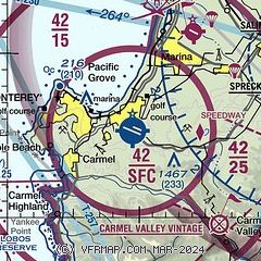
|
CAUTION: Diagram may not be current
 Download PDF
of official airport diagram from the FAA
| Airport distance calculator |
|---|
|
|
| Sunrise and sunset |
|---|
|
Times for 23-Mar-2026
| | Local
(UTC-7) | | Zulu
(UTC) |
|---|
| Morning civil twilight | | 06:42 | | 13:42 |
| Sunrise | | 07:07 | | 14:07 |
| Sunset | | 19:21 | | 02:21 |
| Evening civil twilight | | 19:46 | | 02:46 |
|
| Current date and time |
|---|
| Zulu (UTC) | 23-Mar-2026 12:50:51 |
|---|
| Local (UTC-7) | 23-Mar-2026 05:50:51 |
|---|
|
| METAR |
|---|
| KMRY | 231154Z AUTO 00000KT 9SM CLR 11/09 A3001 RMK AO2 SLP174 T01060089 10122 20100 58008
|
KOAR
6nm NE | 134.025 831-384-2967
231235Z AUTO 25003KT 7SM CLR 08/08 A3003 RMK AO2
|
KSNS
13nm E | 231213Z AUTO 01003KT 5SM BR SCT006 11/10 A3001 RMK AO2 T01110100
|
|
| TAF |
|---|
| KMRY | 231122Z 2312/2412 11003KT 6SM BR FEW007 FM231800 31006KT P6SM SKC FM240300 18003KT P6SM SKC
|
KSNS
13nm E | 231122Z 2312/2412 30004KT 6SM BR SCT007 TEMPO 2312/2315 BKN007 FM231800 31005KT P6SM SKC FM232100 30011KT P6SM SKC FM240500 32004KT P6SM SKC
|
|
| NOTAMs |
|---|
NOTAMs are issued by the DoD/FAA and will open in a separate window not controlled by AirNav.
|
|


