FAA INFORMATION EFFECTIVE 16 APRIL 2026
Location
| FAA Identifier: | N12 |
| Lat/Long: | 40-04-00.8000N 074-10-39.2000W
40-04.013333N 074-10.653333W
40.0668889,-74.1775556
(estimated) |
| Elevation: | 41.9 ft. / 12.8 m (surveyed) |
| Variation: | 13W (2000) |
| From city: | 3 miles SE of LAKEWOOD, NJ |
| Time zone: | UTC -4 (UTC -5 during Standard Time) |
| Zip code: | 08701 |
Airport Operations
| Airport use: | Open to the public |
| Activation date: | 04/1947 |
| Control tower: | no |
| ARTCC: | NEW YORK CENTER |
| FSS: | MILLVILLE FLIGHT SERVICE STATION |
| NOTAMs facility: | MIV (NOTAM-D service available) |
| Attendance: | MAY-OCT 0800-2000, NOV-APR 0800-1800
SVCS AVBL AFT HRS CALL 732-533-3062. |
| Wind indicator: | lighted |
| Segmented circle: | no |
| Lights: | ACTVT PAPI RWY 06 & 24; MIRL RWY 06/24 - CTAF. |
| Beacon: | white-green (lighted land airport)
Operates sunset to sunrise. |
Airport Communications
| CTAF/UNICOM: | 122.8 |
| WX AWOS-AV: | 122.8 (732-363-6471) |
| MC GUIRE APPROACH: | 126.475 |
| MC GUIRE DEPARTURE: | 126.475 |
| WX AWOS-3PT at BLM (8 nm N): | 121.625 (732-938-3330) |
| WX AWOS-3PT at MJX (10 nm SW): | 119.875 (732-797-2542) |
Nearby radio navigation aids
| VOR radial/distance | | VOR name | | Freq | | Var |
|---|
| COLr194/14.7 | | COLTS NECK VOR/DME | | 115.40 | | 11W |
| RBVr129/16.7 | | ROBBINSVILLE VORTAC | | 113.80 | | 10W |
| CYNr048/19.0 | | COYLE VORTAC | | 113.40 | | 10W |
| GXUr092/19.6 | | MC GUIRE VORTAC | | 110.60 | | 12W |
| CRIr213/35.2 | | CANARSIE VOR/DME | | 112.30 | | 11W |
| ARDr118/35.3 | | YARDLEY VOR/DME | | 108.20 | | 10W |
| JFKr221/38.7 | | KENNEDY VOR/DME | | 115.90 | | 12W |
| NDB name | | Hdg/Dist | | Freq | | Var | | ID |
|---|
| LAKEHURST | | 091/7.4 | | 396 | | 11W | | NEL | -. . .-.. |
Airport Services
| Fuel available: | 100LL |
| Parking: | tiedowns |
| Airframe service: | MAJOR |
| Powerplant service: | MAJOR |
| Bottled oxygen: | NONE |
| Bulk oxygen: | NONE |
Runway Information
Runway 6/24
| Dimensions: | 2987 x 60 ft. / 910 x 18 m |
| Surface: | asphalt, in good condition |
| Weight bearing capacity: | |
| Runway edge lights: | medium intensity |
| RUNWAY 6 | | RUNWAY 24 |
| Latitude: | 40-03.845712N | | 40-04.179833N |
| Longitude: | 074-10.888505W | | 074-10.418500W |
| Elevation: | 41.0 ft. | | 33.1 ft. |
| Traffic pattern: | left | | right |
| Runway heading: | 060 magnetic, 047 true | | 240 magnetic, 227 true |
| Displaced threshold: | 261 ft. | | no |
| Markings: | nonprecision, in good condition | | nonprecision, in good condition |
| Visual slope indicator: | 2-light PAPI on right (3.00 degrees glide path) | | 2-light PAPI on left (3.00 degrees glide path) |
| Runway end identifier lights: | yes | | yes |
| Touchdown point: | yes, no lights | | yes, no lights |
| Obstructions: | 10 ft. trees, 258 ft. from runway, 134 ft. left of centerline, 5:1 slope to clear
RY 06 HAS APCH RATIO 52:1 TO DSPLCD THLD. | | 10 ft. road, 200 ft. from runway, 60 ft. right of centerline
RY 24 10 FT ROAD AT RY END 120 FT R CNTRLN. |
Airport Ownership and Management from official FAA records
| Ownership: | Publicly-owned |
| Owner: | LAKEWOOD TOWNSHIP
231 THIRD STREET
LAKEWOOD, NJ 08701
Phone 732-364-2500 |
| Manager: | STEVE REINMAN
231 THIRD STREET
LAKEWOOD, NJ 08701
Phone 732-363-6400
ALT 732-533-3062. |
Additional Remarks
| - | GCO AVBL ON FREQ 121.725 THRU MCGUIRE APCH CTL. IF UNAVBL CTC MC GUIRE APCH AT 609-754-2767. |
| - | HEAVY BANNER TOWING OPS APR-OCT. |
| - | DEER ON AND INVOF OF ARPT. |
| - | FOR CD USE GCO 121.725, IF UNA CTC MC GUIRE APCH AT 609-754-2767. |
Instrument Procedures
NOTE: All procedures below are presented as PDF files. If you need a reader for these files, you should download the free Adobe Reader.NOT FOR NAVIGATION. Please procure official charts for flight.
FAA instrument procedures published for use from 16 April 2026 at 0901Z to 14 May 2026 at 0900Z.
IAPs - Instrument Approach Procedures |
|---|
| RNAV (GPS) RWY 06 **CHANGED** | |
download (207KB) |
| RNAV (GPS) RWY 24 **CHANGED** | |
download (175KB) |
| NOTE: Special Take-Off Minimums/Departure Procedures apply | |
download |
Other nearby airports with instrument procedures:
KBLM - Monmouth Executive Airport (8 nm N)
KNEL - Lakehurst Maxfield Field Airport (8 nm W)
KMJX - Ocean County Airport (10 nm SW)
3N6 - Old Bridge Airport (18 nm NW)
KWRI - McGuire Field (Joint Base Mc Guire Dix Lakehurst) Airport (19 nm W)
|
|

Road maps at:
MapQuest
Bing
Google
| Aerial photo |
|---|
WARNING: Photo may not be current or correct
 Taken in October 2008
Do you have a better or more recent aerial photo of Lakewood Airport that you would like to share? If so, please send us your photo.
|
| Sectional chart |
|---|
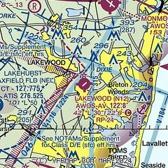
|
| Airport distance calculator |
|---|
|
|
| Sunrise and sunset |
|---|
|
Times for 28-Apr-2026
| | Local
(UTC-4) | | Zulu
(UTC) |
|---|
| Morning civil twilight | | 05:32 | | 09:32 |
| Sunrise | | 06:01 | | 10:01 |
| Sunset | | 19:47 | | 23:47 |
| Evening civil twilight | | 20:16 | | 00:16 |
|
| Current date and time |
|---|
| Zulu (UTC) | 29-Apr-2026 02:58:07 |
|---|
| Local (UTC-4) | 28-Apr-2026 22:58:07 |
|---|
|
| METAR |
|---|
KBLM
7nm NE | AWOS-3 121.625 732-938-3330
290156Z AUTO 13004KT 10SM OVC065 11/06 A3007 RMK AO2 SLP183 T01110061 $
|
KMJX
10nm SW | AWOS-3 119.875 732-244-4450
290156Z AUTO 00000KT 10SM OVC060 11/06 A3007 RMK AO2 SLP185 P0001 T01110056 $
|
KWRI
19nm W | 290155Z AUTO 14003KT 10SM OVC050 12/03 A3006 RMK AO2 SLP179 T01230033 PWINO $
|
|
| TAF |
|---|
KWRI
19nm W | 290200Z 2902/3008 VRB06KT 9999 BKN040 OVC060 QNH2997INS BECMG 2915/2916 15010G15KT 9999 BKN030 OVC055 QNH2979INS TEMPO 2923/3002 13010G20KT 8000 -SHRA BECMG 3001/3002 14012G22KT 6000 SHRA BKN012 OVC025 QNH2970INS TX17/2917Z TN09/2910Z
|
|
| NOTAMs |
|---|
NOTAMs are issued by the DoD/FAA and will open in a separate window not controlled by AirNav.
|
|

