FAA INFORMATION EFFECTIVE 16 APRIL 2026
Location
| FAA Identifier: | OTG |
| Lat/Long: | 43-39-18.2000N 095-34-45.1000W
43-39.303333N 095-34.751667W
43.6550556,-95.5791944
(estimated) |
| Elevation: | 1574 ft. / 479.8 m (surveyed) |
| Variation: | 02E (2015) |
| From city: | 2 miles N of WORTHINGTON, MN |
| Time zone: | UTC -5 (UTC -6 during Standard Time) |
| Zip code: | 56187 |
Airport Operations
| Airport use: | Open to the public |
| Activation date: | 11/1946 |
| Control tower: | no |
| ARTCC: | MINNEAPOLIS CENTER |
| FSS: | PRINCETON FLIGHT SERVICE STATION |
| NOTAMs facility: | OTG (NOTAM-D service available) |
| Attendance: | MON-FRI 0800-1700
FOR SVC CALL 507-376-9293; AFT HRS CALL 507-360-3731. |
| Wind indicator: | lighted |
| Segmented circle: | yes |
| Lights: | ACTVT MALSR RWY 29; REIL RWY 11, 18 & 36; PAPI RWY 18 & 36; MIRL RWY 18/36 - CTAF. HIRL RWY 11/29 PRESET ON LOW INTST; TO INCR INTST - CTAF. PAPI RWY 11 & 29 OPR CONSLY. |
| Beacon: | white-green (lighted land airport)
Operates sunset to sunrise. |
Airport Communications
| CTAF/UNICOM: | 122.8 |
| WX AWOS-3PT: | 121.075 (507-376-9441) |
- APCH/DEP SVC PRVDD BY MINNEAPOLIS ARTCC ON FREQS 132.050/317.4 (SIOUX FALLS RCAG).
Nearby radio navigation aids
| VOR radial/distance | | VOR name | | Freq | | Var |
|---|
| SPWr326/33.9 | | SPENCER VOR/DME | | 115.15 | | 05E |
| NDB name | | Hdg/Dist | | Freq | | Var | | ID |
|---|
| WONDD | | 292/5.5 | | 277 | | 02E | | OT | --- - |
Airport Services
| Fuel available: | 100LL JET-A
A:SELF SVC FUEL AVBL WITH CREDIT CARD. JET A TRUCK AVBL WHEN ATNDD.
100LL:SELF SVC FUEL WITH CREDIT CARD. |
| Parking: | hangars and tiedowns |
| Airframe service: | MAJOR |
| Powerplant service: | MINOR |
| Bottled oxygen: | NONE |
| Bulk oxygen: | NONE |
Runway Information
Runway 11/29
| Dimensions: | 5500 x 100 ft. / 1676 x 30 m |
| Surface: | asphalt/grooved, in fair condition |
| Weight bearing capacity: | | Single wheel: | 44.0 | | Double wheel: | 60.0 |
|
| Runway edge lights: | high intensity |
| RUNWAY 11 | | RUNWAY 29 |
| Latitude: | 43-39.457667N | | 43-39.079072N |
| Longitude: | 095-35.123328W | | 095-33.990922W |
| Elevation: | 1573.5 ft. | | 1566.4 ft. |
| Traffic pattern: | left | | left |
| Runway heading: | 113 magnetic, 115 true | | 293 magnetic, 295 true |
| Markings: | nonprecision, in good condition | | precision, in good condition |
| Visual slope indicator: | 4-light PAPI on left (3.00 degrees glide path) | | 4-light PAPI on left (3.00 degrees glide path) |
| Approach lights: | | | MALSR: 1,400 foot medium intensity approach lighting system with runway alignment indicator lights |
| Runway end identifier lights: | yes | | |
| Touchdown point: | yes, no lights | | yes, no lights |
| Instrument approach: | | | ILS |
Runway 18/36
| Dimensions: | 4200 x 75 ft. / 1280 x 23 m |
| Surface: | asphalt/grooved, in fair condition |
| Weight bearing capacity: | | Single wheel: | 44.0 | | Double wheel: | 60.0 |
|
| Runway edge lights: | medium intensity |
| RUNWAY 18 | | RUNWAY 36 |
| Latitude: | 43-39.695807N | | 43-39.004492N |
| Longitude: | 095-35.008207W | | 095-35.008208W |
| Elevation: | 1571.4 ft. | | 1573.9 ft. |
| Traffic pattern: | left | | left |
| Runway heading: | 178 magnetic, 180 true | | 358 magnetic, 360 true |
| Markings: | nonprecision, in good condition | | nonprecision, in good condition |
| Visual slope indicator: | 4-light PAPI on left (3.00 degrees glide path) | | 4-light PAPI on left (3.00 degrees glide path) |
| Runway end identifier lights: | yes | | yes |
| Touchdown point: | yes, no lights | | yes, no lights |
Airport Ownership and Management from official FAA records
| Ownership: | Publicly-owned |
| Owner: | CITY OF WORTHINGTON
303 NINTH ST., BOX 279
WORTHINGTON, MN 56187-2335
Phone 507-372-8600 |
| Manager: | TODD WIETZEMA
303 NINTH ST., BOX 279
WORTHINGTON, MN 56817-0279
Phone 507-372-8650
CAMERON JOHNSON - 507-376-9293. |
Instrument Procedures
NOTE: All procedures below are presented as PDF files. If you need a reader for these files, you should download the free Adobe Reader.NOT FOR NAVIGATION. Please procure official charts for flight.
FAA instrument procedures published for use from 16 April 2026 at 0901Z to 14 May 2026 at 0900Z.
IAPs - Instrument Approach Procedures |
|---|
| ILS OR LOC RWY 29 | |
download (222KB) |
| RNAV (GPS) RWY 11 | |
download (209KB) |
| RNAV (GPS) RWY 18 | |
download (207KB) |
| RNAV (GPS) RWY 29 | |
download (217KB) |
| RNAV (GPS) RWY 36 | |
download (199KB) |
| NOTE: Special Alternate Minimums apply | |
download (153KB) |
| NOTE: Special Take-Off Minimums/Departure Procedures apply | |
download (405KB) |
Other nearby airports with instrument procedures:
KISB - Sibley Municipal Airport (19 nm SW)
KDVP - Slayton Municipal Airport (22 nm NW)
KMWM - Windom Municipal Airport (26 nm NE)
KMJQ - Jackson Municipal Airport (26 nm E)
4D8 - Fuller Airport (27 nm SE)
|
|

Road maps at:
MapQuest
Bing
Google
| Aerial photo |
|---|
WARNING: Photo may not be current or correct
 Photo taken 28-Feb-2010
Do you have a better or more recent aerial photo of Worthington Municipal Airport that you would like to share? If so, please send us your photo.
|
| Sectional chart |
|---|
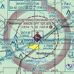
|
| Airport distance calculator |
|---|
|
|
| Sunrise and sunset |
|---|
|
Times for 20-Apr-2026
| | Local
(UTC-5) | | Zulu
(UTC) |
|---|
| Morning civil twilight | | 06:02 | | 11:02 |
| Sunrise | | 06:32 | | 11:32 |
| Sunset | | 20:10 | | 01:10 |
| Evening civil twilight | | 20:41 | | 01:41 |
|
| Current date and time |
|---|
| Zulu (UTC) | 20-Apr-2026 08:29:09 |
|---|
| Local (UTC-5) | 20-Apr-2026 03:29:09 |
|---|
|
| METAR |
|---|
| KOTG | 200756Z AUTO 12003KT 10SM CLR M02/M09 A3025 RMK AO2 SLP260 T10221089 FZRANO
|
|
| NOTAMs |
|---|
NOTAMs are issued by the DoD/FAA and will open in a separate window not controlled by AirNav.
|
|

