FAA INFORMATION EFFECTIVE 07 AUGUST 2025
Location
| FAA Identifier: | PBI |
| Lat/Long: | 26-40-59.3820N 080-05-44.1310W
26-40.989700N 080-05.735517W
26.6831617,-80.0955919
(estimated) |
| Elevation: | 19.6 ft. / 6.0 m (surveyed) |
| Variation: | 06W (2010) |
| From city: | 3 miles W of WEST PALM BEACH, FL |
| Time zone: | UTC -4 (UTC -5 during Standard Time) |
| Zip code: | 33406 |
Airport Operations
| Airport use: | Open to the public |
| Activation date: | 04/1940 |
| Control tower: | yes |
| ARTCC: | MIAMI CENTER |
| FSS: | MIAMI FLIGHT SERVICE STATION |
| NOTAMs facility: | PBI (NOTAM-D service available) |
| Attendance: | CONTINUOUS |
| Wind indicator: | yes |
| Segmented circle: | no |
| Lights: | SS-SR |
| Beacon: | white-green (lighted land airport)
Operates sunset to sunrise. |
| Fire and rescue: | ARFF index C |
| Airline operations: | INDEX D ARFF EQUIPMENT AVAILABLE; 24 HOUR PPR. |
| International operations: | international airport of entry |
Airport Communications
| UNICOM: | 122.95 |
| WX ASOS: | 123.75 (561-683-2548) |
| PALM BEACH GROUND: | 121.9 284.6 |
| PALM BEACH TOWER: | 119.1 257.8 118.75 384.6 |
| PALM BEACH APPROACH: | 125.2 ;SOUTH 128.3 317.4 343.6 ;SOUTH |
| PALM BEACH DEPARTURE: | 125.2 ;SOUTH 128.3 317.4 343.6 ;SOUTH |
| CLEARANCE DELIVERY: | 121.6 284.6 |
| CLASS C: | 125.2 ;SOUTH 128.3 ;NORTH 317.4 ;NORTH 343.6 ;SOUTH |
| CLMNT STAR: | 124.6 317.4 |
| CPTAN STAR: | 124.6 317.4 |
| D-ATIS: | 123.75 |
| EMERG: | 121.5 243.0 |
| IC: | 128.3 317.4 |
| JESTR STAR: | 124.6 317.4 |
| MAHHI STAR: | 127.35 343.6 |
| MELBOURNE STAR: | 124.6 317.4 |
| MIXAE DP: | 127.35 ;RWY 10L, 14 128.3 ;RWY 28R, 32 317.4 ;RWY 28R, 32 343.6 ;RWY 10L, 14 |
| OLAKE DP: | 128.3 317.4 |
| PALM BEACH DP: | 127.35 ;SOUTH 128.3 ;NORTH 317.4 ;NORTH 343.6 ;SOUTH |
| SLIDZ DP: | 128.3 317.4 |
| STOOP STAR: | 124.6 317.4 |
| TBIRD DP: | 128.3 317.4 |
| TTYLR STAR: | 125.2 317.4 |
| VUUDU STAR: | 127.35 317.4 |
| WELLY DP: | 127.35 343.6 |
| WX AWOS-3PT at LNA (5 nm S): | 119.925 (561-964-0308) |
| WX AWOS-3 at F45 (12 nm NW): | 119.975 (561-630-6932) |
| WX AWOS-3 at BCT (18 nm S): | 121.125 (561-391-2696) |
- SAID IN USE. OPERATE TRANSPONDERS WITH ALTITUDE REPORTING MODE AND ADS-B (IF EQUIPPED) ENABLED ON ALL AIRPORT SURFACES.
Nearby radio navigation aids
| VOR radial/distance | | VOR name | | Freq | | Var |
|---|
| PBI at field | | PALM BEACH VORTAC | | 115.70 | | 03W |
| FLLr012/36.8 | | FORT LAUDERDALE VOR/DME | | 114.40 | | 06W |
| NDB name | | Hdg/Dist | | Freq | | Var | | ID |
|---|
| UNITED | | 142/18.7 | | 405 | | 05W | | UTX | ..- - -..- |
Airport Services
| Fuel available: | 100LL JET-A |
| Parking: | tiedowns |
| Airframe service: | MAJOR |
| Powerplant service: | MAJOR |
| Bottled oxygen: | HIGH/LOW |
| Bulk oxygen: | HIGH/LOW |
Runway Information
Runway 10L/28R
| Dimensions: | 10001 x 150 ft. / 3048 x 46 m |
| Surface: | asphalt/grooved, in good condition |
| Weight bearing capacity: | | Single wheel: | 120.0 | | Double wheel: | 250.0 | | Double tandem: | 550.0 | | Dual double tandem: | 1073.0 |
|
| Runway edge lights: | high intensity |
| RUNWAY 10L | | RUNWAY 28R |
| Latitude: | 26-40.992488N | | 26-40.912397N |
| Longitude: | 080-06.502160W | | 080-04.666895W |
| Elevation: | 19.6 ft. | | 16.4 ft. |
| Traffic pattern: | left | | left |
| Runway heading: | 099 magnetic, 093 true | | 279 magnetic, 273 true |
| Displaced threshold: | 1200 ft. | | 811 ft. |
| Declared distances: | TORA:10001 TODA:10001 ASDA:9351 LDA:8151 | | TORA:10001 TODA:10001 ASDA:9051 LDA:8240 |
| Markings: | precision, in good condition | | precision, in good condition |
| Visual slope indicator: | 4-light PAPI on right (3.00 degrees glide path) | | 4-light PAPI on left (3.00 degrees glide path) |
| RVR equipment: | touchdown, rollout | | touchdown, rollout |
| Approach lights: | MALSR: 1,400 foot medium intensity approach lighting system with runway alignment indicator lights | | |
| Runway end identifier lights: | | | yes |
| Centerline lights: | yes | | yes |
| Touchdown point: | yes, no lights | | yes, no lights |
| Instrument approach: | ILS/DME | | LOC/GS |
| Obstructions: | 41 ft. trees, 1665 ft. from runway, 515 ft. left of centerline, 35:1 slope to clear
RWY 10L & RWY 28R APCH RATIO 50:1 AT DISPLACEMENT. | | 40 ft. trees, 2230 ft. from runway, 670 ft. left of centerline |
Runway 14/32
| Dimensions: | 6931 x 150 ft. / 2113 x 46 m |
| Surface: | asphalt/grooved, in fair condition |
| Weight bearing capacity: | | Single wheel: | 120.0 | | Double wheel: | 250.0 | | Double tandem: | 521.0 | | Dual double tandem: | 1042.0 |
|
| Runway edge lights: | medium intensity |
| Operational restrictions: | ARRESTING GEAR/SYSTEM: ENGINEERED MATERIALS ARRESTING SYSTEM (EMAS) 222 FT IN LENGTH BY 170 FT IN WIDTH AT THE DEPARTURE END OF RWY 14. |
| RUNWAY 14 | | RUNWAY 32 |
| Latitude: | 26-41.509933N | | 26-40.698550N |
| Longitude: | 080-06.241367W | | 080-05.343700W |
| Elevation: | 17.0 ft. | | 15.8 ft. |
| Traffic pattern: | left | | left |
| Runway heading: | 141 magnetic, 135 true | | 321 magnetic, 315 true |
| Displaced threshold: | no | | 418 ft. |
| Declared distances: | TORA:6926 TODA:6926 ASDA:6000 LDA:6000 | | TORA:6926 TODA:6926 ASDA:6926 LDA:6513 |
| Markings: | nonprecision, in good condition | | nonprecision, in good condition |
| Visual slope indicator: | 4-light PAPI on right (3.00 degrees glide path) | | 4-light PAPI on left (3.25 degrees glide path) |
| Runway end identifier lights: | yes | | yes |
| Touchdown point: | yes, no lights | | yes, no lights |
| Obstructions: | 34 ft. trees, 1370 ft. from runway, 230 ft. right of centerline, 34:1 slope to clear | | 17 ft. road, 200 ft. from runway, 250 ft. left of centerline
ROAD 200 FT FM AER RWY 32, 250 FT LEFT OF CNTRLN. |
Runway 10R/28L
| Dimensions: | 3214 x 75 ft. / 980 x 23 m |
| Surface: | asphalt, in good condition |
| Weight bearing capacity: | |
| Runway edge lights: | medium intensity |
| RUNWAY 10R | | RUNWAY 28L |
| Latitude: | 26-40.871367N | | 26-40.845545N |
| Longitude: | 080-06.377360W | | 080-05.787502W |
| Elevation: | 17.1 ft. | | 13.6 ft. |
| Traffic pattern: | right | | left |
| Runway heading: | 099 magnetic, 093 true | | 279 magnetic, 273 true |
| Declared distances: | TORA:3214 TODA:3214 ASDA:3214 LDA:3214 | | TORA:3214 TODA:3214 ASDA:3214 LDA:3214 |
| Markings: | basic, in good condition | | basic, in good condition |
| Runway end identifier lights: | yes | | yes |
| Touchdown point: | yes, no lights | | yes, no lights |
| Obstructions: | 30 ft. trees, 1416 ft. from runway, 205 ft. right of centerline, 40:1 slope to clear | | none |
Airport Ownership and Management from official FAA records
| Ownership: | Publicly-owned |
| Owner: | PALM BEACH COUNTY
846 PALM BEACH INTL AIRPORT
WEST PALM BEACH, FL 33406
Phone 561-471-7420 |
| Manager: | LAURA BEEBE
846 PALM BEACH INTL AIRPORT
WEST PALM BEACH, FL 33406
Phone 561-471-7420 |
Additional Remarks
| A39-10L/28R | PCR VALUE: 710/F/B/W/T |
| A39-14/32 | PCR VALUE: 610/F/A/W/T |
| A39-10R/28L | PCR VALUE: 260/F/A/X/T |
| - | MIGRATORY BIRDS ON AND INVOF ARPT. |
| - | BE ALERT: TWY L IS LCTD BTWN RYS 10L/28R & 10R/28L. TWY L IS WIDER AND LONGER THAN RY 10R/28L - DO NOT CONFUSE TWY L FOR RY. AIRCRAFT WITH WINGSPAN OF 118 FT OR GREATER IS PROHIBITED ON TWY L. |
| - | 24 HR PPR FOR ACFT WITH WINGSPANS GTR THAN 171 FT. |
| - | ACFT WITH WINGSPANS GTR THAN 118 FT MAY NOT OPR ON TWY E, TWY W, TWY Y AND TWY F NW OF TWY A. |
| - | RWY 14/32 SAFETY AREA NOT STD SFC VARNS. |
| - | RWY 10L/28R SAFETY AREA NOT STD SFC VARNS. |
| - | ACFT WITH WINGSPANS GTR THAN 49 MAY NOT OPER SIMUL ON RWY 10R/28L AND TWY R. |
| - | RWY 10L/28R SAFETY AREA NOT STD SFC VARNS. |
| - | RWY 14 LAHSO SIGNAGE NOT STD. |
| - | NOISE ABATEMENT PROCEDURES IN EFFECT. MULTIENGINE FLIGHT TRAINING PROHIBITED SS TO SR SUN AND HOLIDAY; STRICT ENVIRONMENTAL OPERATING STAGE 2 ACFT 0300-1200Z CALL NOISE ABATEMENT OFFICER 561-471-7467. |
| - | BE ALERT; RYS 28L & 28R THLDS STAGGERED BY 5400 FT. |
| - | RWY 10R/28L NOT AVBL FOR SKED ACR OPS WITH MORE THAN 9 PAX SEATS OR UNSKED ACR AT LEAST 31 PAX SEATS. |
Instrument Procedures
NOTE: All procedures below are presented as PDF files. If you need a reader for these files, you should download the free Adobe Reader.NOT FOR NAVIGATION. Please procure official charts for flight.
FAA instrument procedures published for use from 07 August 2025 at 0901Z to 04 September 2025 at 0900z.
STARs - Standard Terminal Arrivals |
|---|
| CLMNT TWO (RNAV) | |
2 pages:
[1] [2] (273KB) |
| CLMNT TWO (RNAV), CONT.2 | |
download (202KB) |
| CPTAN THREE (RNAV) | |
2 pages:
[1] [2] (365KB) |
| CPTAN THREE (RNAV), CONT.2 | |
download (262KB) |
| JESTR ONE (RNAV) | |
2 pages:
[1] [2] (270KB) |
| MAHHI THREE (RNAV) | |
2 pages:
[1] [2] (229KB) |
| MELBOURNE TWO | |
download (118KB) |
| STOOP THREE | |
download (125KB) |
| TTYLR FOUR | |
download (162KB) |
| VUUDU ONE (RNAV) | |
2 pages:
[1] [2] (434KB) |
| VUUDU ONE (RNAV), CONT.2 | |
download (192KB) |
IAPs - Instrument Approach Procedures |
|---|
| ILS OR LOC RWY 10L **CHANGED** | |
download (274KB) |
| ILS OR LOC RWY 28R **CHANGED** | |
download (245KB) |
| RNAV (RNP) W RWY 28R **CHANGED** | |
download (214KB) |
| RNAV (RNP) Z RWY 10L **CHANGED** | |
download (208KB) |
| RNAV (RNP) Z RWY 14 **CHANGED** | |
download (199KB) |
| RNAV (RNP) Z RWY 28R **CHANGED** | |
download (213KB) |
| RNAV (RNP) Z RWY 32 **CHANGED** | |
download (226KB) |
| RNAV (GPS) X RWY 28R **CHANGED** | |
download (220KB) |
| RNAV (GPS) Y RWY 10L **CHANGED** | |
download (258KB) |
| RNAV (GPS) Y RWY 14 **CHANGED** | |
download (213KB) |
| RNAV (GPS) Y RWY 28R **CHANGED** | |
download (218KB) |
| RNAV (GPS) Y RWY 32 **CHANGED** | |
download (227KB) |
| NOTE: Special Alternate Minimums apply | |
download (123KB) |
Departure Procedures |
|---|
| MIXAE THREE (RNAV) | |
download (298KB) |
| OLAKE TWO (RNAV) | |
2 pages:
[1] [2] (341KB) |
| PALM BEACH THREE | |
2 pages:
[1] [2] (313KB) |
| SLIDZ TWO (RNAV) | |
2 pages:
[1] [2] (384KB) |
| TBIRD SIX (RNAV) | |
2 pages:
[1] [2] (399KB) |
| TBIRD SIX (RNAV), CONT.2 | |
download (217KB) |
| WELLY THREE (RNAV) | |
download (194KB) |
| NOTE: Special Take-Off Minimums/Departure Procedures apply | |
download (162KB) |
Other nearby airports with instrument procedures:
KLNA - Palm Beach County Park Airport (5 nm S)
F45 - North Palm Beach County General Aviation Airport (12 nm NW)
KBCT - Boca Raton Airport (18 nm S)
06FA - William P Gwinn Airport (18 nm NW)
KPMP - Pompano Beach Airpark (26 nm S)
|
|

Road maps at:
MapQuest
Bing
Google
| Aerial photo |
|---|
WARNING: Photo may not be current or correct
 Photo courtesy of Russell Aerial Photography
Taken in April 2012
looking north.
Photo courtesy of Russell Aerial Photography
Taken in April 2012
looking north.
Do you have a better or more recent aerial photo of Palm Beach International Airport that you would like to share? If so, please send us your photo.
|
| Sectional chart |
|---|
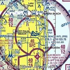
|
CAUTION: Diagram may not be current
 Download PDF
of official airport diagram from the FAA
| Airport distance calculator |
|---|
|
|
| Sunrise and sunset |
|---|
|
Times for 17-Aug-2025
| | Local
(UTC-4) | | Zulu
(UTC) |
|---|
| Morning civil twilight | | 06:30 | | 10:30 |
| Sunrise | | 06:54 | | 10:54 |
| Sunset | | 19:55 | | 23:55 |
| Evening civil twilight | | 20:19 | | 00:19 |
|
| Current date and time |
|---|
| Zulu (UTC) | 17-Aug-2025 20:57:39 |
|---|
| Local (UTC-4) | 17-Aug-2025 16:57:39 |
|---|
|
| METAR |
|---|
| KPBI | 172053Z VRB06KT 10SM TS SCT032CB SCT075 32/24 A2991 RMK AO2 TSB44 SLP126 OCNL LGTICCG SW-NW TS SW-NW MOV N T03220239 55011 $
|
KLNA
5nm S | 172055Z AUTO 11007G14KT 10SM CLR 33/21 A2990 RMK AO2 LTG DSNT W AND NW T03310206
|
KF45
12nm NW | 172035Z AUTO 09009KT 10SM VCTS CLR 30/22 A2989 RMK AO2 LTG DSNT SW-NW
|
KBCT
18nm S | 172053Z 11010G15KT 10SM SCT050 34/25 A2989 RMK LTG DSNT SW AND NW.
|
|
| TAF |
|---|
| KPBI | 171720Z 1718/1818 10008KT P6SM VCSH SCT030 BKN050 FM172000 12010KT P6SM FEW030 SCT050 FM180200 VRB04KT P6SM FEW030 FM181600 07007KT P6SM SCT030 BKN050
|
|
| NOTAMs |
|---|
NOTAMs are issued by the DoD/FAA and will open in a separate window not controlled by AirNav.
|
|


