FAA INFORMATION EFFECTIVE 16 APRIL 2026
Location
| FAA Identifier: | HDH |
| Lat/Long: | 21-34-46.1050N 158-11-50.2130W
21-34.768417N 158-11.836883W
21.5794736,-158.1972814
(estimated) |
| Elevation: | 14.2 ft. / 4.3 m (surveyed) |
| Variation: | 11E (1985) |
| From city: | 2 miles W of MOKULEIA, HI |
| Time zone: | UTC -10 (year round; does not observe DST) |
| Zip code: | 96791 |
Airport Operations
| Airport use: | Open to the public, OPEN TO CIVIL USE THRU AGRMT BTN US ARMY & ST OF HAWAII-CHECK NOTAMS PRIOR TO USE-NO ATCT IN OPN. |
| Control tower: | no |
| ARTCC: | HONOLULU CONTROL FACILITY CENTER |
| FSS: | HONOLULU FLIGHT SERVICE STATION |
| NOTAMs facility: | HNL (NOTAM-D service available) |
| Attendance: | 0700-1530 |
| Pattern altitude: | 800.2 ft. MSL |
| Wind indicator: | yes, WIND INDCRS ARE NOT LGTD. |
| Segmented circle: | no |
Airport Communications
| CTAF/UNICOM: | 123.0 |
| WX ASOS at JRF (18 nm SE): | 119.8 (808-752-3876) |
Nearby radio navigation aids
| VOR radial/distance | | VOR name | | Freq | | Var |
|---|
| HNLr307/22.1 | | HONOLULU VORTAC | | 114.80 | | 11E |
| CKHr293/33.4 | | KOKO HEAD VORTAC | | 113.90 | | 11E |
Airport Services
| Fuel available: | 100 JET-A |
| Parking: | tiedowns |
| Airframe service: | MAJOR |
| Powerplant service: | MAJOR |
Runway Information
Runway 8/26
| Dimensions: | 9007 x 75 ft. / 2745 x 23 m |
| Surface: | asphalt, in fair condition |
| Weight bearing capacity: | | Single wheel: | 40.0 | | Double wheel: | 152.0 | | Double tandem: | 180.0 |
|
| Operational restrictions: | RWY 08/26 CLSD FOR MILITARY TRAINING 0800-1700Z. |
| RUNWAY 8 | | RUNWAY 26 |
| Latitude: | 21-34.775950N | | 21-34.760833N |
| Longitude: | 158-12.632083W | | 158-11.041683W |
| Elevation: | 14.2 ft. | | 10.2 ft. |
| Traffic pattern: | left | | right |
| Runway heading: | 080 magnetic, 091 true | | 260 magnetic, 271 true |
| Displaced threshold: | 1993 ft. | | 1995 ft. |
| Markings: | basic, in fair condition | | basic, in fair condition |
| Runway end identifier lights: | no | | no |
| Touchdown point: | yes, no lights | | yes, no lights |
| Obstructions: | none
50:1 TO DSPLCD THR. | | 60 ft. trees, 1400 ft. from runway, 100 ft. right of centerline, 20:1 slope to clear
APCH RATIO 50:1 TO DSPLCD THLD. |
Airport Ownership and Management from official FAA records
| Ownership: | U.S. Army |
| Owner: | US ARMY
USARPAC
HONOLULU, HAWAII, HI 96819
Phone 808-656-1027
US ARMY SUPPORT COMMAND HI, FORT SHAFTER HI 96858. |
| Manager: | MALCOM SMITH
300 RODGERS BLVD NR 12
HONOLULU, HI 96819-1897
Phone 808-836-6533
PHONE AT ARPT 637-8270. FAX 637-8291. UNICOM OPERATOR 637-8271. |
Additional Remarks
| - | SIMULTANEOUS GLIDER/POWERED ACFT OPNS. |
| - | ULTRALIGHTS ON & INVOF ARPT. |
| - | TREE LINE WITH 90 FT TREES NORTH & SOUTH OF RY APRXLY 425 FT FROM CNTRLN. |
| - | MARKED DEPRESSION INVOF THE AUTOMATED FUEL PUMP ON SOUTHWESTERN APRON. |
| - | PPR FOR CIVIL ACFT 12500 LBS AND OVER, CTC ARPT AIRSIDE OPS MGR AT (808) 836-6428 MON-FRI, 0745-1630. |
| - | RSTD: PPR MUST BE MADE NO LESS THAN 72 HRS FOR ALL MIL FIXED WING ACFT INTO ARPT. CTC USA HAWAII RANGE CTL C808-787-5126/5103. |
| - | FOR CD CTC HONOLULU CONTROL FACILITY AT 808-840-6262. |
| - | EXTNSV MIL HELICOPTER & GLIDER OPNS DAILY. AEROBATIC TRAINING OFFSHORE N OF AIRFIELD ABV 1500'. |
| - | CLSD TO CIVIL ACFT 1900-0700 APR 1-SEP 30 AND 1800-0600 OCT 1-MAR 31. |
| - | SKY DIVING ACTIVITY ON AND INVOF ARPT. |
| - | CTN: LARGE SEA BIRDS ON AND INVOF ARPT NOVEMBER THROUGH APRIL. |
| - | NO RUNNING LNDGS WITH SKID TYPE HELICOPTER ON RWY - APVD TWYS ONLY. |
| - | A 5000 X 75 FT RWY FOR LGT POWERED ACFT HAS BEEN PAINTED IN THE CENTER OF EXISTING 9007 X 75 FT PAVED AREA FOR CIVIL USE STARTING APPROX 2000 FT FM EACH RWY END. |
| - | POWERED ACFT SHALL KEEP BASE LEG IN CLOSE AND CROSS THE ARPT BOUNDARY FENCES AT OR ABOVE 600 FT MSL IN ORDER TO ASSURE SAFE SEPARATION FROM SAILPLANES/TOWPLANES USING THE FIRST 2000 FT (SHORT OF THE DSPLCE THLD). |
Instrument Procedures
There are no published instrument procedures at PHDH.
Some nearby airports with instrument procedures:
PHHI - Wheeler Army Airfield (11 nm SE)
PHJR - Kalaeloa Airport (John Rodgers Field) (18 nm SE)
PHNL - Daniel K Inouye International Airport (22 nm SE)
PHNG - Kaneohe Bay Marine Corps Air Station (Marion E Carl Field) (25 nm E)
PHMK - Molokai Airport (67 nm E)
|
|

Road maps at:
MapQuest
Bing
Google
| Aerial photo |
|---|
WARNING: Photo may not be current or correct
 Photo taken 11-Feb-2007
Do you have a better or more recent aerial photo of Kawaihapai Airfield that you would like to share? If so, please send us your photo.
|
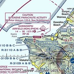
| Sectional chart |
|---|
|
| Airport distance calculator |
|---|
|
|
| Sunrise and sunset |
|---|
|
Times for 17-Apr-2026
| | Local
(UTC-10) | | Zulu
(UTC) |
|---|
| Morning civil twilight | | 05:50 | | 15:50 |
| Sunrise | | 06:13 | | 16:13 |
| Sunset | | 18:52 | | 04:52 |
| Evening civil twilight | | 19:15 | | 05:15 |
|
| Current date and time |
|---|
| Zulu (UTC) | 17-Apr-2026 17:21:00 |
|---|
| Local (UTC-10) | 17-Apr-2026 07:21:00 |
|---|
|
| METAR |
|---|
PHHI
12nm SE | 171655Z AUTO 00000KT 10SM CLR 21/17 A3007 RMK AO2 SLP173 T02080172 $
|
PHJR
17nm SE | 171653Z 06003KT 10SM CLR 21/19 A3005 RMK AO2 SLP183 T02110189 $
|
PHNL
20nm SE | 171653Z 06009KT 10SM FEW025 24/18 A3005 RMK AO2 SLP174 T02440183 $
|
|
| TAF |
|---|
PHJR
17nm SE | 171129Z 1712/1812 VRB05KT P6SM FEW030 FM172000 11010KT P6SM SCT035 FM180500 07005KT P6SM FEW030
|
|
| NOTAMs |
|---|
NOTAMs are issued by the DoD/FAA and will open in a separate window not controlled by AirNav.
|
|

