FAA INFORMATION EFFECTIVE 16 APRIL 2026
Location
| FAA Identifier: | PIM |
| Lat/Long: | 32-50-26.5000N 084-52-56.8000W
32-50.441667N 084-52.946667W
32.8406944,-84.8824444
(estimated) |
| Elevation: | 902 ft. / 274.9 m (surveyed) |
| Variation: | 03W (2000) |
| From city: | 2 miles SW of PINE MOUNTAIN, GA |
| Time zone: | UTC -4 (UTC -5 during Standard Time) |
| Zip code: | 31822 |
Airport Operations
| Airport use: | Open to the public |
| Control tower: | no |
| ARTCC: | ATLANTA CENTER |
| FSS: | MACON FLIGHT SERVICE STATION |
| NOTAMs facility: | MCN (NOTAM-D service available) |
| Attendance: | 0900-1700 |
| Wind indicator: | lighted |
| Segmented circle: | yes |
| Lights: | ACTVT MIRL RWY 09/27 - CTAF. PAPI RWY 09 & 27 OPR CONSLY. |
| Beacon: | white-green (lighted land airport)
Operates sunset to sunrise. |
Airport Communications
| CTAF/UNICOM: | 122.8 |
| WX AWOS-3PT: | 120.275 (706-663-2081) |
| ATLANTA APPROACH: | 125.5 126.55 ;7000 FT & ABV |
| ATLANTA DEPARTURE: | 125.5 126.55 ;7000 FT & ABV |
| CLEARANCE DELIVERY: | 127.7 |
| WX AWOS-3PT at 5A9 (11 nm NE): | 118.35 (706-655-2005) |
| WX AWOS-3 at LGC (14 nm NW): | 126.325 (706-845-0677) |
| WX ASOS at CSG (20 nm S): | PHONE 706-748-8097 |
- ATLANTA LARGE TRACON PROVIDES APCH/DEP SVC 0615-2300 ON FREQ 125.5; ATLANTA ARTCC PROVIDES APCH/DEP SVC 2300-0615 ON FREQS 120.45/298.850 & CLNC DEL ON FREQ 120.45 (COLUMBUS RCAG).
Nearby radio navigation aids
| VOR radial/distance | | VOR name | | Freq | | Var |
|---|
| LGCr126/20.5 | | LAGRANGE VORTAC | | 115.60 | | 01E |
| LSFr015/31.0 | | LAWSON VOR/DME | | 111.40 | | 05W |
| NDB name | | Hdg/Dist | | Freq | | Var | | ID |
|---|
| COWETA COUNTY | | 202/26.4 | | 234 | | 03W | | EQQ | . --.- --.- |
| PECAT | | 221/34.0 | | 316 | | 05W | | FFC | ..-. ..-. -.-. |
Airport Services
| Fuel available: | 100LL JET-A+
100LL:FUEL 24 HR CREDIT CARD SVC AVBL. |
| Parking: | hangars and tiedowns |
| Airframe service: | MAJOR |
| Powerplant service: | MAJOR |
| Bottled oxygen: | NONE |
| Bulk oxygen: | NONE |
Runway Information
Runway 9/27
| Dimensions: | 5002 x 100 ft. / 1525 x 30 m |
| Surface: | asphalt, in good condition |
| Weight bearing capacity: | |
| Runway edge lights: | medium intensity |
| RUNWAY 9 | | RUNWAY 27 |
| Latitude: | 32-50.430313N | | 32-50.453402N |
| Longitude: | 084-53.434512W | | 084-52.457877W |
| Elevation: | 902.0 ft. | | 900.1 ft. |
| Traffic pattern: | left | | left |
| Runway heading: | 091 magnetic, 088 true | | 271 magnetic, 268 true |
| Markings: | nonprecision, in good condition | | nonprecision, in good condition |
| Visual slope indicator: | 4-light PAPI on left (3.00 degrees glide path) | | 4-light PAPI on left (3.00 degrees glide path) |
| Touchdown point: | yes, no lights | | yes, no lights |
| Obstructions: | 40 ft. trees, 1080 ft. from runway, 366 ft. left of centerline, 22:1 slope to clear | | 85 ft. trees, 1305 ft. from runway, 396 ft. right of centerline, 13:1 slope to clear |
Airport Ownership and Management from official FAA records
| Ownership: | Publicly-owned |
| Owner: | HARRIS COUNTY BOC
COUNTY COURTHOUSE, 104 N. COLLEGE STREET
HAMILTON, GA 31811
Phone 706-628-4958 |
| Manager: | RONALD PENDERGRASS
789 SKY MEADOW DRIVE
PINE MOUNTAIN, GA 31822
Phone 706-663-2083
AFT HRS CALL 770-880-0765. |
Additional Remarks
| - | GCO AVBL ON FREQ 121.725 THRU MCN CLEARANCE DELIVERY. |
Instrument Procedures
NOTE: All procedures below are presented as PDF files. If you need a reader for these files, you should download the free Adobe Reader.NOT FOR NAVIGATION. Please procure official charts for flight.
FAA instrument procedures published for use from 16 April 2026 at 0901Z to 14 May 2026 at 0900Z.
IAPs - Instrument Approach Procedures |
|---|
| RNAV (GPS) RWY 09 **CHANGED** | |
download (227KB) |
| NOTE: Special Alternate Minimums apply | |
download (158KB) |
| NOTE: Special Take-Off Minimums/Departure Procedures apply | |
download (189KB) |
Other nearby airports with instrument procedures:
KLGC - LaGrange-Callaway Airport (14 nm NW)
7A3 - Lanett Regional Airport (18 nm W)
KCSG - Columbus Airport (20 nm S)
KCCO - Newnan Coweta County Airport (29 nm N)
KAUO - Auburn University Regional Airport (31 nm SW)
|
|

Road maps at:
MapQuest
Bing
Google
| Aerial photo |
|---|
WARNING: Photo may not be current or correct
 Photo by Shawn McDaniel
Photo taken 19-Feb-2018
looking east.
Photo by Shawn McDaniel
Photo taken 19-Feb-2018
looking east.
Do you have a better or more recent aerial photo of Harris County Airport that you would like to share? If so, please send us your photo.
|
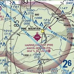
| Sectional chart |
|---|
|
| Airport distance calculator |
|---|
|
|
| Sunrise and sunset |
|---|
|
Times for 17-Apr-2026
| | Local
(UTC-4) | | Zulu
(UTC) |
|---|
| Morning civil twilight | | 06:43 | | 10:43 |
| Sunrise | | 07:08 | | 11:08 |
| Sunset | | 20:10 | | 00:10 |
| Evening civil twilight | | 20:35 | | 00:35 |
|
| Current date and time |
|---|
| Zulu (UTC) | 17-Apr-2026 07:48:43 |
|---|
| Local (UTC-4) | 17-Apr-2026 03:48:43 |
|---|
|
| METAR |
|---|
| KPIM | 170735Z AUTO VRB01KT 10SM BKN050 15/15 A3005 RMK AO2
|
KLGC
13nm NW | 170735Z AUTO 00000KT 10SM SCT065 13/12 A3005 RMK AO2
|
KCSG
20nm S | 170651Z AUTO 00000KT 10SM CLR 17/13 A3005 RMK AO2 SLP171 T01720128
|
|
| TAF |
|---|
KCSG
20nm S | 170536Z 1706/1806 19004KT P6SM SKC FM171600 26005KT P6SM FEW050 FEW250 FM180200 23003KT P6SM SCT250
|
|
| NOTAMs |
|---|
NOTAMs are issued by the DoD/FAA and will open in a separate window not controlled by AirNav.
|
|


