FAA INFORMATION EFFECTIVE 09 JULY 2026
Location
| FAA Identifier: | PMP |
| Lat/Long: | 26-14-50.4960N 080-06-40.0590W
26-14.841600N 080-06.667650W
26.2473600,-80.1111275
(estimated) |
| Elevation: | 19.3 ft. / 5.9 m (surveyed) |
| Variation: | 07W (2015) |
| From city: | 1 mile NE of POMPANO BEACH, FL |
| Time zone: | UTC -4 (UTC -5 during Standard Time) |
| Zip code: | 33062 |
Airport Operations
| Airport use: | Open to the public |
| Activation date: | 07/1944 |
| Control tower: | yes |
| ARTCC: | MIAMI CENTER |
| FSS: | MIAMI FLIGHT SERVICE STATION |
| NOTAMs facility: | PMP (NOTAM-D service available) |
| Attendance: | 0700-1900 |
| Pattern altitude: | 819.3 ft. MSL |
| Wind indicator: | lighted |
| Segmented circle: | no |
| Lights: | REIL RWY 06 & 24, 33; PAPI RWY 10 & 28 OPR DUSK TO DAWN. WHEN ATCT CLSD ACTVT MALS RWY 15 - CTAF. MIRL RWY 15/33 & RWY MOST ALIGNED TO WIND PRESET MED INTST ONLY. |
| Beacon: | white-green (lighted land airport)
Operates sunset to sunrise. |
Airport Communications
| CTAF: | 125.4 |
| UNICOM: | 122.95 |
| ATIS: | 120.55 |
| WX ASOS: | 120.55 (954-783-3720) |
| POMPANO BEACH GROUND: | 121.9 [0700-2100] |
| POMPANO BEACH TOWER: | 125.4 [0700-2100] |
| MIAMI APPROACH: | 119.7 |
| MIAMI DEPARTURE: | 119.7 |
| BHHIA STAR: | 120.5 |
| BNICE DP: | 126.05 |
| CPTAN STAR: | 124.6 |
| DEKAL STAR: | 126.85 |
| DORRL DP: | 126.05 |
| FEALX DP: | 126.05 |
| FORT LAUDERDALE DP: | 126.05 ;AARPS, BNICE, DORRL,FRSBE, H 126.05 ;BEECH-FLL DEPARTING WEST 126.85 ;BEECH-FLL DEPARTING EAST 126.85 ;MAYNR |
| FORTL STAR: | 133.775 |
| FRSBE DP: | 126.05 |
| GABOW DP: | 126.05 |
| HROCK DP: | 126.05 |
| JESTR STAR: | 124.6 |
| KYAKS STAR: | 128.6 |
| LIFRR DP: | 126.05 |
| MAYNR DP: | 126.05 |
| OLAHS STAR: | 126.85 ;6000 FT AND ABV 128.6 ;5000 FT & BLW |
| TEEKY STAR: | 133.775 |
| TOREZ STAR: | 126.85 |
| WX ASOS at FXE (4 nm SW): | 119.85 (954-772-2537) |
| WX AWOS-3 at BCT (8 nm N): | PHONE 561-391-2696 |
| WX ASOS at FLL (11 nm S): | 135.0 (954-359-7857) |
| WX ASOS at HWO (16 nm SW): | 135.475 (954-983-5904) |
- MIAMI APCH/DEP FREQS USABLE 4000' AND BELOW.
Nearby radio navigation aids
| VOR radial/distance | | VOR name | | Freq | | Var |
|---|
| FLLr022/10.8 | | FORT LAUDERDALE VOR/DME | | 114.40 | | 06W |
| PBIr186/26.0 | | PALM BEACH VORTAC | | 115.70 | | 03W |
| DHPr030/29.8 | | DOLPHIN VORTAC | | 113.90 | | 04W |
| VKZr008/29.8 | | VIRGINIA KEY VOR/DME | | 117.10 | | 04W |
Airport Services
| Fuel available: | 100LL JET-A |
| Parking: | hangars and tiedowns |
| Airframe service: | MAJOR |
| Powerplant service: | MAJOR |
| Bottled oxygen: | HIGH/LOW |
| Bulk oxygen: | HIGH/LOW |
Runway Information
Runway 15/33
| Dimensions: | 4918 x 150 ft. / 1499 x 46 m |
| Surface: | asphalt, in good condition |
| Weight bearing capacity: | | PCN 21 /F/B/X/T | | Single wheel: | 30.0, LTD TO GWT 30000 LBS OR LESS. |
|
| Runway edge lights: | medium intensity |
| RUNWAY 15 | | RUNWAY 33 |
| Latitude: | 26-15.261088N | | 26-14.615680N |
| Longitude: | 080-06.916900W | | 080-06.370782W |
| Elevation: | 16.5 ft. | | 12.6 ft. |
| Traffic pattern: | left | | left |
| Runway heading: | 150 magnetic, 143 true | | 330 magnetic, 323 true |
| Displaced threshold: | 501 ft. | | 340 ft. |
| Markings: | nonprecision, in fair condition | | nonprecision, in fair condition |
| Visual slope indicator: | 4-light PAPI on left (3.00 degrees glide path) | | 4-light PAPI on left (3.00 degrees glide path) |
| Approach lights: | MALS: 1,400 foot medium intensity approach lighting system | | |
| Runway end identifier lights: | | | yes |
| Touchdown point: | yes, no lights | | yes, no lights |
| Instrument approach: | LOC/DME | | |
| Obstructions: | 48 ft. pline, 1815 ft. from runway, 275 ft. left of centerline, 33:1 slope to clear
APCH SLOPE 48:1 TO DSPLCD THR. | | 42 ft. trees, 1260 ft. from runway, 300 ft. left of centerline, 25:1 slope to clear
APCH SLP 37:1 TO DTHR. |
Runway 6/24
| Dimensions: | 4001 x 150 ft. / 1220 x 46 m |
| Surface: | asphalt, in fair condition |
| Weight bearing capacity: | | PCN 6 /F/B/Y/T | | Single wheel: | 20.0, LTD TO GWT 12500 LBS OR LESS. |
|
| Runway edge lights: | medium intensity |
| RUNWAY 6 | | RUNWAY 24 |
| Latitude: | 26-14.638198N | | 26-15.038690N |
| Longitude: | 080-06.992868W | | 080-06.410677W |
| Elevation: | 19.3 ft. | | 12.9 ft. |
| Traffic pattern: | left | | left |
| Runway heading: | 060 magnetic, 053 true | | 240 magnetic, 233 true |
| Markings: | basic, in good condition | | basic, in good condition |
| Visual slope indicator: | 2-light PAPI on left (3.75 degrees glide path) | | 2-light PAPI on left (3.50 degrees glide path) |
| Runway end identifier lights: | yes | | yes |
| Touchdown point: | yes, no lights | | yes, no lights |
| Obstructions: | 40 ft. trees, 845 ft. from runway, 225 ft. left of centerline, 16:1 slope to clear | | 59 ft. trees, 1395 ft. from runway, 150 ft. left of centerline, 20:1 slope to clear |
Runway 10/28
| Dimensions: | 3687 x 100 ft. / 1124 x 30 m |
| Surface: | asphalt, in fair condition |
| Weight bearing capacity: | | PCN 8 /F/B/Y/T | | Single wheel: | 26.0, LTD TO GWT 12500 LBS OR LESS. |
|
| Runway edge lights: | medium intensity |
| RUNWAY 10 | | RUNWAY 28 |
| Latitude: | 26-14.756393N | | 26-14.675447N |
| Longitude: | 080-06.996878W | | 080-06.327935W |
| Elevation: | 18.3 ft. | | 10.7 ft. |
| Traffic pattern: | left | | left |
| Runway heading: | 105 magnetic, 098 true | | 285 magnetic, 278 true |
| Displaced threshold: | no | | 185 ft. |
| Markings: | basic, in good condition | | basic, in good condition |
| Visual slope indicator: | 2-light PAPI on left (3.75 degrees glide path) | | 2-light PAPI on left (3.90 degrees glide path) |
| Runway end identifier lights: | yes | | yes |
| Touchdown point: | yes, no lights | | yes, no lights |
| Obstructions: | 37 ft. tree, 925 ft. from runway, 90 ft. right of centerline, 19:1 slope to clear
RWY 28 APRCH SLOPE 24:1 TO DISP T-HOLD. | | 25 ft. trees, 410 ft. from runway, 105 ft. right of centerline, 8:1 slope to clear |
Airport Ownership and Management from official FAA records
| Ownership: | Publicly-owned |
| Owner: | CITY OF POMPANO BEACH
100 WEST ATLANTIC BOULEVARD, CITY HALL
POMPANO BEACH, FL 33061
Phone 954-786-4601 |
| Manager: | STEVEN ROCCO
POMPANO BEACH AIRPARK, 1001 NORTHEAST 10TH STREET
POMPANO BEACH, FL 33060
Phone 954-786-4135 |
Additional Remarks
| A93 | BELL HEL SVC CTR ON ARPT. |
| - | NMRS BIRDS ON & INVOF ARPT. |
| - | ALL RWYS NOISE SENSITIVE ALL QUADRANTS; CTC AMGR FOR HEL & FIXED WING OPS. TGL OPNS PMTD MON-FRI 0900-1800 AND LTD AS POSS ON WKENDS AND LEGAL HOLS. STOP AND GO OPNS AND INTERSECTION TKOFS STGLY DISCOURAGED AT ALL TIMES. |
| - | FOR CD WHEN ATCT CLSD CTC MIAMI APCH AT 305-869-5432. |
| - | ACFT WITH GWT MORE THAN 30000 LBS PPR ON RWY 15/33. ACFT EXCEEDING 12500 PROHIBITED ON RWY 10/28. |
Instrument Procedures
NOTE: All procedures below are presented as PDF files. If you need a reader for these files, you should download the free Adobe Reader.NOT FOR NAVIGATION. Please procure official charts for flight.
FAA instrument procedures published for use from 09 July 2026 at 0901Z to 06 August 2026 at 0900Z.
STARs - Standard Terminal Arrivals |
|---|
| BHHIA THREE (RNAV) **NEW** | |
2 pages:
[1] [2] (393KB) |
| BHHIA THREE (RNAV), CONT.2 **NEW** | |
download (148KB) |
| CPTAN FOUR (RNAV) **NEW** | |
2 pages:
[1] [2] (383KB) |
| CPTAN FOUR (RNAV), CONT.2 **NEW** | |
download (261KB) |
| DEKAL NINE **NEW** | |
download (214KB) |
| DVALL FOUR **NEW** | |
download (144KB) |
| FORTL NINE **NEW** | |
download (185KB) |
| JESTR TWO (RNAV) **NEW** | |
2 pages:
[1] [2] (278KB) |
| KYAKS THREE (RNAV) **NEW** | |
2 pages:
[1] [2] (305KB) |
| OLAHS THREE (RNAV) **NEW** | |
2 pages:
[1] [2] (404KB) |
| OLAHS THREE (RNAV), CONT.2 **NEW** | |
download (162KB) |
| TEEKY FOUR (RNAV) **NEW** | |
2 pages:
[1] [2] (586KB) |
| TOREZ ONE (RNAV) **NEW** | |
download (151KB) |
IAPs - Instrument Approach Procedures |
|---|
| RNAV (GPS) RWY 06 | |
download (197KB) |
| RNAV (GPS) RWY 15 | |
download (194KB) |
| RNAV (GPS) RWY 24 | |
download (212KB) |
| RNAV (GPS) RWY 33 | |
download (205KB) |
| LOC RWY 15 | |
download (193KB) |
| NOTE: Special Alternate Minimums apply | |
download (20KB) |
Departure Procedures |
|---|
| BNICE TWO (RNAV) | |
download (243KB) |
| DORRL TWO (RNAV) | |
download (259KB) |
| FEALX TWO (RNAV) | |
2 pages:
[1] [2] (339KB) |
| FORT LAUDERDALE TWO | |
2 pages:
[1] [2] (402KB) |
| FORT LAUDERDALE TWO | |
2 pages:
[1] [2] (402KB) |
| FRSBE TWO (RNAV) | |
download (247KB) |
| GABOW TWO (RNAV) | |
download (267KB) |
| HROCK TWO (RNAV) | |
2 pages:
[1] [2] (323KB) |
| LIFRR TWO (RNAV) | |
download (239KB) |
| MAYNR THREE (RNAV) | |
2 pages:
[1] [2] (265KB) |
| NOTE: Special Take-Off Minimums/Departure Procedures apply | |
download (411KB) |
Other nearby airports with instrument procedures:
KFXE - Fort Lauderdale Executive Airport (4 nm SW)
KBCT - Boca Raton Airport (8 nm N)
KFLL - Fort Lauderdale/Hollywood International Airport (11 nm S)
KHWO - North Perry Airport (16 nm SW)
KLNA - Palm Beach County Park Airport (21 nm N)
|
|

Road maps at:
MapQuest
Bing
Google
| Aerial photo |
|---|
WARNING: Photo may not be current or correct
 Photo by Dave Fogarty ATP-CFI-A&P-IA
Photo taken 13-Apr-2019
2,000 MSL looking southeast.
Photo by Dave Fogarty ATP-CFI-A&P-IA
Photo taken 13-Apr-2019
2,000 MSL looking southeast.
Do you have a better or more recent aerial photo of Pompano Beach Airpark that you would like to share? If so, please send us your photo.
|
| Sectional chart |
|---|
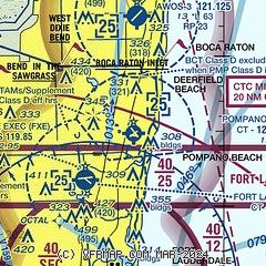
|
CAUTION: Diagram may not be current
 Download PDF
of official airport diagram from the FAA
| Airport distance calculator |
|---|
|
|
| Sunrise and sunset |
|---|
|
Times for 25-Jul-2026
| | Local
(UTC-4) | | Zulu
(UTC) |
|---|
| Morning civil twilight | | 06:18 | | 10:18 |
| Sunrise | | 06:43 | | 10:43 |
| Sunset | | 20:10 | | 00:10 |
| Evening civil twilight | | 20:36 | | 00:36 |
|
| Current date and time |
|---|
| Zulu (UTC) | 25-Jul-2026 04:03:57 |
|---|
| Local (UTC-4) | 25-Jul-2026 00:03:57 |
|---|
|
| METAR |
|---|
| KPMP | 250353Z AUTO 13008KT 10SM FEW024 30/26 A3010 RMK AO2 SLP193 T03000256
|
KFXE
5nm SW | 250353Z AUTO 16009G19KT 6SM -RA BR FEW022 SCT029 SCT041 28/27 A3010 RMK AO2 RAB52 SLP195 P0002 T02830267
|
KBCT
8nm N | 250355Z AUTO 15007KT 10SM SCT022 SCT032 BKN038 29/26 A3010 RMK AO2 LTG DSNT ALQDS 403260255
|
KFLL
11nm S | 250353Z 13008KT 10SM SCT025 30/25 A3009 RMK AO2 SLP186 T03000250 PNO
|
KHWO
16nm SW | 250353Z AUTO RMK AO2 SLPNO PWINO TSNO $
|
|
| TAF |
|---|
KFXE
5nm SW | 242032Z 2421/2518 11010KT P6SM VCTS SCT025CB BKN050 FM250200 VRB05KT P6SM FEW025 SCT050 FM251500 13008KT P6SM VCSH SCT025 BKN050
|
KFLL
11nm S | 242032Z 2421/2524 11010KT P6SM VCTS SCT025CB BKN050 FM250200 VRB04KT P6SM FEW025 SCT050 FM251500 14008KT P6SM VCSH SCT025 BKN050 FM251800 13010KT P6SM VCTS SCT025CB BKN050 PROB30 2518/2524 VRB15G25KT 3SM TSRA BKN020CB
|
|
| NOTAMs |
|---|
NOTAMs are issued by the DoD/FAA and will open in a separate window not controlled by AirNav.
|
|


