FAA INFORMATION EFFECTIVE 14 MAY 2026
Location
| FAA Identifier: | RED |
| Lat/Long: | 45-11-05.4000N 109-15-27.7550W
45-11.090000N 109-15.462583W
45.1848333,-109.2577097
(estimated) |
| Elevation: | 5762 ft. / 1756.3 m (surveyed) |
| Variation: | 15E (1985) |
| From city: | 1 mile NW of RED LODGE, MT |
| Time zone: | UTC -6 (UTC -7 during Standard Time) |
| Zip code: | 59068 |
Airport Operations
| Airport use: | Open to the public |
| Activation date: | 04/1940 |
| Control tower: | no |
| ARTCC: | SALT LAKE CITY CENTER |
| FSS: | GREAT FALLS FLIGHT SERVICE STATION |
| NOTAMs facility: | GTF (NOTAM-D service available) |
| Attendance: | UNATNDD |
| Wind indicator: | lighted |
| Segmented circle: | yes |
| Lights: | ACTVT VASI 16; MIRL RWY 16/34 - CTAF. |
| Beacon: | white-green (lighted land airport)
Operates sunset to sunrise. |
Airport Communications
Nearby radio navigation aids
| VOR radial/distance | | VOR name | | Freq | | Var |
|---|
| CODr326/36.1 | | CODY VOR/DME | | 111.80 | | 14E |
Airport Services
| Fuel available: | 100LL
100LL:H24 CREDIT CARD; AVBLTY - 715-781-7054. |
| Parking: | tiedowns |
Runway Information
Runway 16/34
| Dimensions: | 4000 x 75 ft. / 1219 x 23 m |
| Surface: | asphalt, in poor condition
EDGE CRACKING & ERODING; LOOSE SFC GRVL. |
| Weight bearing capacity: | | Single wheel: | 4.0 | | Double wheel: | 6.0 |
|
| Runway edge lights: | medium intensity |
| Runway edge markings: | FADED. |
| Operational restrictions: | NOISE ABATEMENT PROC IN EFCT; PILOTS REQSTD TO; RWY 16 ARR FLY DNWND AT TFC PAT ALT OVR BLUFF E OF DOWNTOWN & WHEN SAFE & PRACTICAL FLY HIGH ANGLE FINAL APP SLP; RWY 34 DEP, MNVR ON UPWIND TO W OF RESIDENTIAL AREA N OF ARPT AS SOON AS SAFE & PRACTICAL; RWY 34 ARR, FLY DNWND W OF RESIDENTIAL AREA W. CROSSWIND GRASS STRIPS; LIMIT OPNS TO/FROM XWIND GRASS STRIPS & FLY STD TFC PATTERNS AT TPA TO MINIMIZE IMPACTS UPON CITY DOWNTOWN & RESIDENTIAL AREAS IMMEDIATELY E OF ARPT. |
| RUNWAY 16 | | RUNWAY 34 |
| Latitude: | 45-11.418667N | | 45-10.761333N |
| Longitude: | 109-15.484500W | | 109-15.440667W |
| Elevation: | 5696.8 ft. | | 5762.0 ft. |
| Traffic pattern: | left | | left |
| Runway heading: | 162 magnetic, 177 true | | 342 magnetic, 357 true |
| Markings: | basic, in poor condition | | basic, in poor condition |
| Visual slope indicator: | 2-box VASI on left (3.00 degrees glide path) | | |
| Touchdown point: | yes, no lights | | yes, no lights |
| Obstructions: | 14 ft. tree, 408 ft. from runway, 14:1 slope to clear | | 10 ft. road, 288 ft. from runway, 50 ft. both sides of centerline, 8:1 slope to clear
+4 FT FENCE & +10 FT ROAD 100-110 FT RIGHT X CNTRLN 288 FT FM THR. -400 FT TRRN DROPOFF 150 FT R. |
Airport Ownership and Management from official FAA records
| Ownership: | Publicly-owned |
| Owner: | CITY OF RED LODGE- CARBON CO
P.O. BOX 887
RED LODGE, MT 59068
Phone 406-446-1595 |
| Manager: | BO EWALD
PO BOX 887
RED LODGE, MT 59068
Phone 406-425-1591 |
Additional Remarks
| - | WILDLIFE ON & INVOF ARPT. |
| - | AUTOMATED UNICOM: 2 CLICKS ON 122.725. |
| - | FOR CD CTC SALT LAKE ARTCC AT 801-320-2568. |
| - | COND UNMNT; SEE HTTPS://WEATHERCAMS.FAA.GOV OR FOR CURRENT RWY COND - AMGR. |
| - | GRASS STRIP OPS; FLY STD TFC PAT ALT; LMT OPS. |
Instrument Procedures
There are no published instrument procedures at KRED.
Some nearby airports with instrument procedures:
KPOY - Powell Municipal Airport (27 nm SE)
6S8 - Laurel Municipal Airport (38 nm NE)
U68 - North Big Horn County Airport (38 nm SE)
KCOD - Yellowstone Regional Airport (41 nm S)
KBIL - Billings Logan International Airport (48 nm NE)
|
|

Road maps at:
MapQuest
Bing
Google
| Aerial photo |
|---|
WARNING: Photo may not be current or correct
 Photo by Maria Guy
Photo taken 10-Oct-2010
looking north east.
Photo by Maria Guy
Photo taken 10-Oct-2010
looking north east.
Do you have a better or more recent aerial photo of Red Lodge Airport that you would like to share? If so, please send us your photo.
|
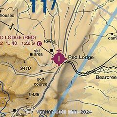
| Sectional chart |
|---|
|
| Airport distance calculator |
|---|
|
|
| Sunrise and sunset |
|---|
|
Times for 31-May-2026
| | Local
(UTC-6) | | Zulu
(UTC) |
|---|
| Morning civil twilight | | 04:58 | | 10:58 |
| Sunrise | | 05:34 | | 11:34 |
| Sunset | | 20:55 | | 02:55 |
| Evening civil twilight | | 21:31 | | 03:31 |
|
| Current date and time |
|---|
| Zulu (UTC) | 31-May-2026 08:38:39 |
|---|
| Local (UTC-6) | 31-May-2026 02:38:39 |
|---|
|
| METAR |
|---|
KPOY
27nm SE | 310815Z AUTO 33013KT 10SM CLR 10/07 A2988 RMK AO2 LTG DSNT NE AND E
|
K6S8
38nm NE | 310815Z AUTO 29008KT 10SM BKN050 14/14 A2987 RMK A01
|
KU68
38nm SE | 310815Z AUTO 31009G21KT 10SM BKN080 OVC120 13/10 A2984 RMK AO2 TSNO
|
KCOD
41nm S | 310756Z AUTO 00000KT 10SM CLR 11/08 A2993 RMK AO2 SLP104 T01060083 $
|
KBIL
47nm NE | 310753Z 24004KT 10SM FEW017 SCT039 OVC055 14/12 A2985 RMK AO2 RAB06E20 SLP086 P0000 T01390122
|
K6S0
48nm NW | 310745Z AUTO 25024G29KT 9SM FEW004 FEW040 OVC050 10/09 A2990 RMK A01
|
|
| NOTAMs |
|---|
NOTAMs are issued by the DoD/FAA and will open in a separate window not controlled by AirNav.
|
|

