FAA INFORMATION EFFECTIVE 18 APRIL 2024
Location
| FAA Identifier: | RPH |
| Lat/Long: | 33-06-38.6000N 098-33-17.2000W
33-06.643333N 098-33.286667W
33.1107222,-98.5547778
(estimated) |
| Elevation: | 1123 ft. / 342.3 m (surveyed) |
| Variation: | 07E (1995) |
| From city: | 2 miles E of GRAHAM, TX |
| Time zone: | UTC -5 (UTC -6 during Standard Time) |
| Zip code: | 76450 |
Airport Operations
| Airport use: | Open to the public |
| Activation date: | 02/1947 |
| Control tower: | no |
| ARTCC: | FORT WORTH CENTER |
| FSS: | FORT WORTH FLIGHT SERVICE STATION |
| NOTAMs facility: | RPH (NOTAM-D service available) |
| Attendance: | MON-FRI 0800-1700 |
| Wind indicator: | lighted |
| Segmented circle: | yes |
| Lights: | MIRL RWY 03/21 SS-SR PRESET TO LOW, TO INCR INTST ACTVT - CTAF. |
| Beacon: | white-green (lighted land airport)
Operates sunset to sunrise. |
Airport Communications
| CTAF/UNICOM: | 122.975 |
| WX AWOS-3P: | 118.025 (940-521-0685) |
- APCH/DEP CTL SVC PRVDD BY FORT WORTH ARTCC (ZFW) ON FREQS 127.0/360.6 (MINERAL WELLS RCAG).
Nearby radio navigation aids
| VOR radial/distance | | VOR name | | Freq | | Var |
|---|
| MQPr300/36.3 | | MILLSAP VORTAC | | 117.70 | | 09E |
Airport Services
| Fuel available: | 100LL JET-A JET-A+ |
| Parking: | hangars and tiedowns |
| Airframe service: | MAJOR |
| Powerplant service: | MAJOR |
| Bottled oxygen: | NONE |
| Bulk oxygen: | NONE |
Runway Information
Runway 3/21
| Dimensions: | 5000 x 75 ft. / 1524 x 23 m |
| Surface: | asphalt, in good condition |
| Weight bearing capacity: | |
| Runway edge lights: | medium intensity |
| RUNWAY 3 | | RUNWAY 21 |
| Latitude: | 33-06.342525N | | 33-06.977613N |
| Longitude: | 098-33.577615W | | 098-32.952887W |
| Elevation: | 1113.6 ft. | | 1114.2 ft. |
| Traffic pattern: | left | | left |
| Runway heading: | 033 magnetic, 040 true | | 213 magnetic, 220 true |
| Markings: | nonprecision, in good condition | | nonprecision, in good condition |
| Visual slope indicator: | 2-light PAPI on left (3.00 degrees glide path) | | 2-light PAPI on right (3.00 degrees glide path) |
| Touchdown point: | yes, no lights | | yes, no lights |
| Obstructions: | 15 ft. trees, 201 ft. from runway, 86 ft. left of centerline
15 FT TREES 0-200 FT DSTC. | | 53 ft. trees, 253 ft. from runway, 247 ft. right of centerline, 1:1 slope to clear
25 FT TREE, 190 FT DSTC, 245 FT L. |
Runway 18/36
| Dimensions: | 3317 x 50 ft. / 1011 x 15 m |
| Surface: | asphalt, in fair condition |
| Weight bearing capacity: | |
| RUNWAY 18 | | RUNWAY 36 |
| Latitude: | 33-06.891667N | | 33-06.345350N |
| Longitude: | 098-33.303683W | | 098-33.333800W |
| Elevation: | 1103.9 ft. | | 1122.8 ft. |
| Traffic pattern: | left | | left |
| Runway heading: | 176 magnetic, 183 true | | 356 magnetic, 003 true |
| Displaced threshold: | 639 ft. | | no |
| Markings: | basic, in fair condition | | basic, in fair condition |
| Touchdown point: | yes, no lights | | yes, no lights |
| Obstructions: | 15 ft. road, 200 ft. from runway
21 FT RD, 62 FT DSTC, 7 FT FENCE 0 FT DSTC. | | 21 ft. road, 201 ft. from runway
10 FT TREE, 10 FT DSTC, 90 FT R. |
Airport Ownership and Management from official FAA records
| Ownership: | Publicly-owned |
| Owner: | CITY OF GRAHAM
BOX 1449
GRAHAM, TX 76450
Phone 940-549-3324 |
| Manager: | JON DELAMARTER
PO BOX 1449
GRAHAM, TX 76450
Phone 940-549-6150 |
Airport Operational Statistics
| Aircraft based on the field: | | 46 | | Single engine airplanes: | | 36 | | Multi engine airplanes: | | 3 | | Jet airplanes: | | 1 | | Helicopters: | | 6 |
| |  | |
| Aircraft operations: avg 37/day * | | 91% | local general aviation | | 9% | transient general aviation | | <1% | military | | * for 12-month period ending 05 November 2023 | |
Additional Remarks
| - | WILDLIFE ON & INVOF ARPT. |
| - | FOR CD CTC FORT WORTH ARTCC AT 817-858-7584. |
Instrument Procedures
NOTE: All procedures below are presented as PDF files. If you need a reader for these files, you should download the free Adobe Reader.NOT FOR NAVIGATION. Please procure official charts for flight.
FAA instrument procedures published for use from 18 April 2024 at 0901Z to 16 May 2024 at 0900Z.
IAPs - Instrument Approach Procedures |
|---|
| RNAV (GPS) RWY 03 | |
download (232KB) |
| RNAV (GPS) RWY 21 | |
download (208KB) |
| NOTE: Special Alternate Minimums apply | |
download (21KB) |
| NOTE: Special Take-Off Minimums/Departure Procedures apply | |
download (217KB) |
Other nearby airports with instrument procedures:
F35 - Possum Kingdom Airport (13 nm SE)
KONY - Olney Municipal Airport (20 nm NW)
KBKD - Stephens County Airport (29 nm SW)
KMWL - Mineral Wells Regional Airport (32 nm SE)
KXBP - Bridgeport Municipal Airport (37 nm E)
|
|

Road maps at:
MapQuest
Bing
Google
| Aerial photo |
|---|
WARNING: Photo may not be current or correct

Do you have a better or more recent aerial photo of Graham Municipal Airport that you would like to share? If so, please send us your photo.
|
| Sectional chart |
|---|
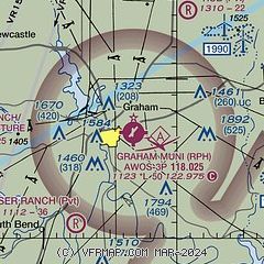
|
| Airport distance calculator |
|---|
|
|
| Sunrise and sunset |
|---|
|
Times for 25-Apr-2024
| | Local
(UTC-5) | | Zulu
(UTC) |
|---|
| Morning civil twilight | | 06:27 | | 11:27 |
| Sunrise | | 06:53 | | 11:53 |
| Sunset | | 20:12 | | 01:12 |
| Evening civil twilight | | 20:38 | | 01:38 |
|
| Current date and time |
|---|
| Zulu (UTC) | 25-Apr-2024 15:26:15 |
|---|
| Local (UTC-5) | 25-Apr-2024 10:26:15 |
|---|
|
| METAR |
|---|
| KRPH | 251515Z AUTO 13008KT 100V180 10SM OVC043 21/19 A2994 RMK AO2 T02150186
|
|
| NOTAMs |
|---|
NOTAMs are issued by the DoD/FAA and will open in a separate window not controlled by AirNav.
|
|


