FAA INFORMATION EFFECTIVE 19 MARCH 2026
Location
| FAA Identifier: | RQO |
| Lat/Long: | 35-28-21.8000N 098-00-20.7000W
35-28.363333N 098-00.345000W
35.4727222,-98.0057500
(estimated) |
| Elevation: | 1420.4 ft. / 432.9 m (surveyed) |
| Variation: | 04E (2020) |
| From city: | 4 miles SW of EL RENO, OK |
| Time zone: | UTC -5 (UTC -6 during Standard Time) |
| Zip code: | 73036 |
Airport Operations
| Airport use: | Open to the public |
| Activation date: | 02/1943 |
| Control tower: | no |
| ARTCC: | FORT WORTH CENTER |
| FSS: | MC ALESTER FLIGHT SERVICE STATION |
| NOTAMs facility: | RQO (NOTAM-D service available) |
| Attendance: | MON - FRI 0800-1700, ALL SAT-SUN 0900-1600 |
| Wind indicator: | lighted |
| Segmented circle: | yes |
| Lights: | ACTVT REIL RWY 17 & 35; MIRL RWY 17/35 - CTAF. PAPI RWY 17 & 35 OPR CONSLY. |
| Beacon: | white-green (lighted land airport)
Operates sunset to sunrise. |
Airport Communications
| CTAF/UNICOM: | 122.8 |
| WX AWOS-3: | 118.475 (405-262-0087) |
| OKE CITY APPROACH: | 124.6 |
| OKE CITY DEPARTURE: | 124.6 |
| WX AWOS-3 at RCE (9 nm E): | 125.05 (405-354-2617) |
| WX AWOS-3 at HSD (17 nm NE): | 120.975 (405-283-9848) |
| WX ASOS at PWA (18 nm E): | PHONE 405-798-2013 |
Nearby radio navigation aids
| VOR radial/distance | | VOR name | | Freq | | Var |
|---|
| PWAr250/17.9 | | WILEY POST VOR/DME | | 113.40 | | 08E |
| IRWr282/20.6 | | WILL ROGERS VORTAC | | 114.10 | | 07E |
Airport Services
| Fuel available: | 100LL JET-A+
100LL:AVBL H24 WITH CREDIT CARD.
A+:FULL SVC AVBL. |
| Parking: | hangars and tiedowns |
| Airframe service: | MAJOR |
| Powerplant service: | MAJOR |
Runway Information
Runway 17/35
| Dimensions: | 5600 x 75 ft. / 1707 x 23 m |
| Surface: | concrete/grooved, in good condition |
| Weight bearing capacity: | |
| Runway edge lights: | medium intensity |
| RUNWAY 17 | | RUNWAY 35 |
| Latitude: | 35-28.872430N | | 35-27.949442N |
| Longitude: | 098-00.260163W | | 098-00.258868W |
| Elevation: | 1420.4 ft. | | 1416.9 ft. |
| Traffic pattern: | left | | right |
| Runway heading: | 176 magnetic, 180 true | | 356 magnetic, 360 true |
| Markings: | nonprecision, in good condition | | nonprecision, in good condition |
| Visual slope indicator: | 4-light PAPI on left (3.00 degrees glide path) | | 4-light PAPI on left (3.00 degrees glide path) |
| Runway end identifier lights: | yes | | yes |
| Touchdown point: | yes, no lights | | yes, no lights |
| Obstructions: | 51 ft. pline, marked, 1855 ft. from runway, 32:1 slope to clear | | 12 ft. road, 450 ft. from runway, 20:1 slope to clear |
Runway 18/36
| Dimensions: | 4017 x 190 ft. / 1224 x 58 m |
| Surface: | turf, in fair condition |
| RUNWAY 18 | | RUNWAY 36 |
| Latitude: | 35-28.626185N | | 35-27.964052N |
| Longitude: | 098-00.466920W | | 098-00.459602W |
| Elevation: | 1416.1 ft. | | 1417.2 ft. |
| Traffic pattern: | right | | left |
| Runway heading: | 175 magnetic, 179 true | | 355 magnetic, 359 true |
| Markings: | none | | none |
| Touchdown point: | yes, no lights | | yes, no lights |
| Obstructions: | 15 ft. road, 280 ft. from runway, 90 ft. right of centerline, 18:1 slope to clear | | 25 ft. pline, 360 ft. from runway, 95 ft. left of centerline, 14:1 slope to clear |
Airport Ownership and Management from official FAA records
| Ownership: | Publicly-owned |
| Owner: | CITY OF EL RENO
PO BOX 700
EL RENO, OK 73036
Phone 405-295-9343 |
| Manager: | SCOTT LAW
PO BOX 700
EL RENO, OK 73036
Phone 405-295-9343
AFT HRS CTC: 405-520-2442. |
Additional Remarks
| - | FOR CD CTC OKE CITY APCH AT 405-681-5683. |
Instrument Procedures
NOTE: All procedures below are presented as PDF files. If you need a reader for these files, you should download the free Adobe Reader.NOT FOR NAVIGATION. Please procure official charts for flight.
FAA instrument procedures published for use from 19 March 2026 at 0901Z to 16 April 2026 at 0900Z.
STARs - Standard Terminal Arrivals |
|---|
| GULLI THREE | |
2 pages:
[1] [2] (336KB) |
IAPs - Instrument Approach Procedures |
|---|
| RNAV (GPS) RWY 17 **CHANGED** | |
download (195KB) |
| RNAV (GPS) RWY 35 **CHANGED** | |
download (215KB) |
| NOTE: Special Alternate Minimums apply | |
download (108KB) |
| NOTE: Special Take-Off Minimums/Departure Procedures apply | |
download (131KB) |
Other nearby airports with instrument procedures:
KRCE - Clarence E Page Municipal Airport (9 nm E)
KHSD - Sundance Airport (17 nm NE)
2O8 - Hinton Municipal Airport (17 nm W)
KPWA - Wiley Post Airport (18 nm E)
KOKC - OKC Will Rogers International Airport (20 nm E)
|
|

Road maps at:
MapQuest
Bing
Google
| Aerial photo |
|---|
WARNING: Photo may not be current or correct
 Photo by Dean Ritter of Aerial Oklahoma
Do you have a better or more recent aerial photo of El Reno Regional Airport that you would like to share? If so, please send us your photo.
|
| Sectional chart |
|---|
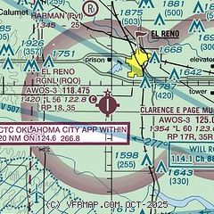
|
CAUTION: Diagram may not be current

| Airport distance calculator |
|---|
|
|
| Sunrise and sunset |
|---|
|
Times for 24-Mar-2026
| | Local
(UTC-5) | | Zulu
(UTC) |
|---|
| Morning civil twilight | | 07:06 | | 12:06 |
| Sunrise | | 07:31 | | 12:31 |
| Sunset | | 19:46 | | 00:46 |
| Evening civil twilight | | 20:11 | | 01:11 |
|
| Current date and time |
|---|
| Zulu (UTC) | 25-Mar-2026 03:07:02 |
|---|
| Local (UTC-5) | 24-Mar-2026 22:07:02 |
|---|
|
| METAR |
|---|
| KRQO | 250255Z AUTO 13009KT 10SM CLR 16/09 A3001 RMK AO2
|
KRCE
9nm E | 250255Z AUTO 14009KT 10SM SCT036 19/09 A3001 RMK AO2
|
KHSD
17nm NE | 250255Z AUTO 15008KT 10SM CLR 21/09 A3000 RMK A01
|
KPWA
18nm E | 250253Z AUTO 14009KT 10SM CLR 21/09 A3001 RMK AO2 SLP153 T02110094 51012
|
|
| TAF |
|---|
KOKC
21nm E | 241725Z 2418/2518 17011KT P6SM FEW050 SCT250 FM251400 19014G24KT P6SM FEW250
|
|
| NOTAMs |
|---|
NOTAMs are issued by the DoD/FAA and will open in a separate window not controlled by AirNav.
|
|


