FAA INFORMATION EFFECTIVE 14 MAY 2026
Location
| FAA Identifier: | S18 |
| Lat/Long: | 47-56-15.7860N 124-23-45.3140W
47-56.263100N 124-23.755233W
47.9377183,-124.3959206
(estimated) |
| Elevation: | 299 ft. / 91 m (estimated) |
| Variation: | 21E (1985) |
| From city: | 1 mile SW of FORKS, WA |
| Time zone: | UTC -7 (UTC -8 during Standard Time) |
| Zip code: | 98331 |
Airport Operations
| Airport use: | Open to the public |
| Activation date: | 01/1939 |
| Control tower: | no |
| ARTCC: | SEATTLE CENTER |
| FSS: | SEATTLE FLIGHT SERVICE STATION |
| NOTAMs facility: | SEA (NOTAM-D service available) |
| Attendance: | UNATNDD |
| Wind indicator: | lighted |
| Segmented circle: | yes |
| Lights: | SS-SR |
Airport Communications
| CTAF: | 122.9 |
| WX ASOS at UIL (7 nm W): | 135.225 (360-374-9731) |
Nearby radio navigation aids
| VOR radial/distance | | VOR name | | Freq | | Var |
|---|
| TOUr135/23.6 | | TATOOSH VORTAC | | 112.20 | | 22E |
Airport Services
| Parking: | tiedowns |
| Bottled oxygen: | NONE |
| Bulk oxygen: | NONE |
Runway Information
Runway 4/22
| Dimensions: | 2400 x 75 ft. / 732 x 23 m |
| Surface: | asphalt, in good condition |
| Runway edge lights: | medium intensity |
| Operational restrictions: | ALL PATTERNS NORTH OF FIELD. |
| RUNWAY 4 | | RUNWAY 22 |
| Traffic pattern: | left | | right |
| Markings: | basic, in good condition | | basic, in good condition |
| Runway end identifier lights: | no | | no |
| Obstructions: | 45 ft. trees, 419 ft. from runway, 50 ft. left of centerline, 4:1 slope to clear
ROW OF JERSEY BARRIERS 142 FT EAST OF CNTRLN EXTENDING FULL LENGTH OF THE RY; 4 FT SIGN, 61 FT FROM THR, 115 FT RIGHT. | | 80 ft. tree, 597 ft. from runway, 147 ft. left of centerline, 4:1 slope to clear
4 FT SIGN, 70 FT FROM THR, 90 FT LEFT. |
Airport Ownership and Management from official FAA records
| Ownership: | Publicly-owned |
| Owner: | CITY OF FORKS
FORKS CITY HALL, 500 EAST DIVISION STREET
FORKS, WA 98331
Phone 360-374-5412 |
| Manager: | CARYN DEPEW
FORKS CITY HALL , 500 EAST DIVISION STREET
FORKS, WA 98331
Phone 360-374-5412
EXTENSION 240 |
Additional Remarks
| - | PARALLEL TW MARKED WITH REFLECTORS. |
| - | WILDLIFE ON & INVOF ARPT. |
| - | FOR CD CTC SEATTLE ARTCC AT 253-351-3694. |
Instrument Procedures
There are no published instrument procedures at S18.
Some nearby airports with instrument procedures:
KCLM - William R Fairchild International Airport (38 nm E)
KNOW - Port Angeles Coast Guard Air Station Airport (41 nm E)
KHQM - Bowerman Field Airport (61 nm S)
0S9 - Jefferson County International Airport (64 nm E)
KFHR - Friday Harbor Airport (65 nm NE)
|
|

Road maps at:
MapQuest
Bing
Google
| Aerial photo |
|---|
WARNING: Photo may not be current or correct
 Photo courtesy of longbachnguyen.com
Photo taken 14-Jul-2008
Photo courtesy of longbachnguyen.com
Photo taken 14-Jul-2008
Do you have a better or more recent aerial photo of Forks Airport that you would like to share? If so, please send us your photo.
|
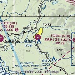
| Sectional chart |
|---|
|
| Airport distance calculator |
|---|
|
|
| Sunrise and sunset |
|---|
|
Times for 01-Jun-2026
| | Local
(UTC-7) | | Zulu
(UTC) |
|---|
| Morning civil twilight | | 04:44 | | 11:44 |
| Sunrise | | 05:23 | | 12:23 |
| Sunset | | 21:07 | | 04:07 |
| Evening civil twilight | | 21:47 | | 04:47 |
|
| Current date and time |
|---|
| Zulu (UTC) | 02-Jun-2026 02:24:59 |
|---|
| Local (UTC-7) | 01-Jun-2026 19:24:59 |
|---|
|
| METAR |
|---|
KUIL
6nm W | 020153Z AUTO 33006KT 10SM CLR 24/07 A3006 RMK AO2 SLP178 T02390067 $
|
|
| TAF |
|---|
KCLM
38nm E | 011724Z 0118/0218 07008KT P6SM SCT200 FM020000 27005KT P6SM SCT200 FM020900 24004KT P6SM SCT200
|
|
| NOTAMs |
|---|
NOTAMs are issued by the DoD/FAA and will open in a separate window not controlled by AirNav.
|
|

