FAA INFORMATION EFFECTIVE 30 OCTOBER 2025
Location
| FAA Identifier: | SBD |
| Lat/Long: | 34-05-43.3000N 117-14-05.6000W
34-05.721667N 117-14.093333W
34.0953611,-117.2348889
(estimated) |
| Elevation: | 1159.3 ft. / 353.4 m (surveyed) |
| Variation: | 13E (2005) |
| From city: | 2 miles SE of SAN BERNARDINO, CA |
| Time zone: | UTC -8 (UTC -7 during Daylight Saving Time) |
| Zip code: | 92408 |
Airport Operations
| Airport use: | Open to the public |
| Activation date: | 07/1940 |
| Control tower: | yes |
| ARTCC: | LOS ANGELES CENTER |
| FSS: | RIVERSIDE FLIGHT SERVICE STATION |
| NOTAMs facility: | SBD (NOTAM-D service available) |
| Attendance: | MON-SUN 0700-2100 |
| Pattern altitude: | 1959.3 ft. MSL |
| Wind indicator: | lighted |
| Segmented circle: | yes |
| Lights: | WHEN ATCT CLSD HIRL PRESET LOW INTST, TO INCREASE INTST AND ACTVT REILS RYS 06 & 24 ACTVT - CTAF. PAPI RYS 06 AND RY 24 OPER CONTINUOUSLY. |
| Beacon: | white-green (lighted land airport)
Operates sunset to sunrise. |
| Landing fee: | yes |
| Fire and rescue: | ARFF index C |
| International operations: | US CUSTOMS USER FEE ARPT. |
Airport Communications
| CTAF: | 119.45 |
| UNICOM: | 122.975 |
| WX AWOS-3: | PHONE 909-382-0067 |
| SAN BERNARDINO GROUND: | 121.8 [0700-2100] |
| SAN BERNARDINO TOWER: | 119.45 [0700-2100] |
| SOCAL APPROACH: | 127.0 ;NORTH-NE 134.0 ;NORTHEAST-SOUTH 135.4 ;SOUTH-SW |
| SOCAL DEPARTURE: | 127.0 ;NORTH-NE 134.0 ;NORTHEAST-SOUTH 135.4 ;SOUTH-SW |
| CLASS C: | 125.5 ;SW-NORTH 127.0 ;NORTH-NE 134.0 ;NORTHEAST-SOUTH |
| D-ATIS: | 124.175 |
| OPS: | 279.65 |
| SETER STAR: | 127.0 |
| ZIGGY STAR: | 127.0 |
| WX ASOS at RAL (14 nm SW): | 128.8 (951-352-4392) |
| WX ASOS at ONT (18 nm W): | PHONE 909-937-2186 |
Nearby radio navigation aids
| VOR radial/distance | | VOR name | | Freq | | Var |
|---|
| RALr038/(13.6) | | RIVERSIDE VOR | | 108.60 | | 14E |
| PDZr039/18.1 | | PARADISE VORTAC | | 112.20 | | 15E |
| HDFr339/(19.3) | | HOMELAND VOR | | 112.05 | | 14E |
| POMr073/27.5 | | POMONA VORTAC | | 110.40 | | 15E |
| VCVr152/30.9 | | VICTORVILLE VOR/DME | | 109.05 | | 14E |
| ELBr030/35.3 | | EL TORO VOR/DME | | 117.20 | | 14E |
| NDB name | | Hdg/Dist | | Freq | | Var | | ID |
|---|
| PETIS | | 056/6.9 | | 397 | | 14E | | SB | ... -... |
Airport Services
| Fuel available: | 100LL JET-A |
| Parking: | tiedowns |
| Airframe service: | MAJOR |
| Powerplant service: | MAJOR |
| Bulk oxygen: | HIGH |
Runway Information
Runway 6/24
| Dimensions: | 10000 x 200 ft. / 3048 x 61 m |
| Surface: | concrete/grooved, in excellent condition |
| Weight bearing capacity: | | Single wheel: | 97.0 | | Double wheel: | 265.0 | | Double tandem: | 890.0 | | Dual double tandem: | 960.0 |
|
| Runway edge lights: | high intensity |
| RUNWAY 6 | | RUNWAY 24 |
| Latitude: | 34-05.445282N | | 34-05.997352N |
| Longitude: | 117-15.026227W | | 117-13.158982W |
| Elevation: | 1084.4 ft. | | 1159.3 ft. |
| Traffic pattern: | right | | left |
| Runway heading: | 057 magnetic, 070 true | | 237 magnetic, 250 true |
| Declared distances: | TORA:10000 TODA:10000 ASDA:10000 LDA:10000 | | TORA:10000 TODA:10000 ASDA:10000 LDA:10000 |
| Markings: | precision, in good condition | | precision, in good condition |
| Visual slope indicator: | 4-light PAPI on left (3.00 degrees glide path) | | 4-light PAPI on left (3.00 degrees glide path) |
| RVR equipment: | touchdown, midfield, rollout | | touchdown, midfield, rollout |
| Runway end identifier lights: | yes | | yes |
| Touchdown point: | yes, no lights | | yes, no lights |
| Instrument approach: | ILS | | |
Airport Ownership and Management from official FAA records
| Ownership: | Publicly-owned |
| Owner: | SAN BERNARDINO INTL AIRPORT AUTH
1601 E 3RD STREET
SAN BERNARDINO, CA 92408
Phone 909-382-4100 |
| Manager: | JONATHAN GALVAN
1601 EAST 3RD STREET
SAN BERNARDINO, CA 92408
Phone 909-382-4100 |
Additional Remarks
| A39-06/24 | PCR VALUE: 1260/R/B/W/T |
| - | RY 06/24 STRENGTH RATED FOR THE A380 AT 1,300,000 LBS. |
| - | PERIODIC LIVE FIREFIGHTING TRAINING PRODUCING SMOKE AND LIGHT EMMISIONS APPROX 6,000 FT NE OF RY 6 THLD. |
| - | ATCT NON VISIBLE AREA ON TWY ALPHA 425 FT WEST OF TWY ALPHA 1. |
| - | AFTER HOURS GENERAL AVIATION ACCESS AND FUEL AVBL WITH PPR CALL FIXED BASE OPERATORS AT 909-382-6068. |
| - | AIRFIELD SFC COND NOT MNT BTN THE HRS 2000-0500. |
| - | TWY A, A1, E, ACFT WINGSPAN MORE THAN 171 FT USE INBOARD ENGS DRG TAX. |
| - | FOR CD WHEN ATCT CLSD CTC SOCAL APCH AT 800-448-3724. |
| - | REDLANDS ARPT (REI) 4.5 NM EAST TPA 2500 MSL CTAF/AUNICOM 123.05. AEROBATIC AREA 6.2 NM EAST 3500-7000 MSL. RMN VIGILANT TO SEE AND AVOID. |
| - | HIGH TERRAIN N AND E OF APT. |
| - | RY 06 DESIGNATED CALM WIND RY. |
| - | FIRE FIGHTING ACFT CTC US FOREST SVC TANKER BASE ON GND FREQ 123.975. |
Instrument Procedures
NOTE: All procedures below are presented as PDF files. If you need a reader for these files, you should download the free Adobe Reader.NOT FOR NAVIGATION. Please procure official charts for flight.
FAA instrument procedures published for use from 30 October 2025 at 0901Z to 27 November 2025 at 0900Z.
STARs - Standard Terminal Arrivals |
|---|
| SETER FIVE **CHANGED** | |
download (242KB) |
| ZIGGY EIGHT | |
2 pages:
[1] [2] (400KB) |
IAPs - Instrument Approach Procedures |
|---|
| ILS OR LOC Z RWY 06 | |
download (387KB) |
| RNAV (RNP) RWY 24 | |
download (395KB) |
| RNAV (RNP) X RWY 06 | |
download (373KB) |
| RNAV (GPS) Y RWY 06 | |
download (359KB) |
| RNAV (GPS) Z RWY 06 | |
download (359KB) |
| LOC Y RWY 06 | |
download (389KB) |
| NOTE: Special Alternate Minimums apply | |
download (37KB) |
Departure Procedures |
|---|
| JADKO ONE (RNAV) | |
download (290KB) |
| NOTE: Special Take-Off Minimums/Departure Procedures apply | |
download (132KB) |
Other nearby airports with instrument procedures:
KREI - Redlands Municipal Airport (4 nm E)
KRIR - Flabob Airport (11 nm SW)
KRIV - March Air Reserve Base (13 nm S)
KRAL - Riverside Municipal Airport (14 nm SW)
KONT - Ontario International Airport (18 nm W)
|
|

Road maps at:
MapQuest
Bing
Google
| Aerial photo |
|---|
WARNING: Photo may not be current or correct
 Photo courtesy of focalflight.com
Photo taken 09-Feb-2017
looking east.
Photo courtesy of focalflight.com
Photo taken 09-Feb-2017
looking east.
Do you have a better or more recent aerial photo of San Bernardino International Airport that you would like to share? If so, please send us your photo.
|
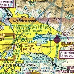
| Sectional chart |
|---|
|
CAUTION: Diagram may not be current
 Download PDF
of official airport diagram from the FAA
| Airport distance calculator |
|---|
|
|
| Sunrise and sunset |
|---|
|
Times for 09-Nov-2025
| | Local
(UTC-8) | | Zulu
(UTC) |
|---|
| Morning civil twilight | | 05:51 | | 13:51 |
| Sunrise | | 06:17 | | 14:17 |
| Sunset | | 16:49 | | 00:49 |
| Evening civil twilight | | 17:15 | | 01:15 |
|
| Current date and time |
|---|
| Zulu (UTC) | 09-Nov-2025 17:50:07 |
|---|
| Local (UTC-8) | 09-Nov-2025 09:50:07 |
|---|
|
| METAR |
|---|
| KSBD | 091652Z 00000KT 10SM CLR 24/00 A3012
|
KRAL
14nm SW | 091653Z 09003KT 10SM CLR 23/07 A3010 RMK AO2 SLP179 T02280072 $
|
KRIV
14nm S | 091655Z AUTO 34004KT 10SM CLR 26/02 A3010 RMK AO2 SLP181 T02640016
|
KONT
18nm W | 091653Z 00000KT 10SM CLR 22/09 A3009 RMK AO2 SLP181 T02170089 $
|
|
| TAF |
|---|
| KSBD | 091120Z 0912/1012 VRB05KT P6SM SKC
|
KRIV
14nm S | 091220Z 0912/1018 VRB04KT 9999 SKC 510303 QNH3003INS BECMG 0917/0918 03009KT 9999 SKC 510006 QNH3005INS WND 330V080 TEMPO 0919/1001 04012G18KT BECMG 1001/1002 34009KT 9999 FEW300 510303 QNH3009INS BECMG 1005/1006 VRB04KT 9999 FEW300 510303 QNH3013INS BECMG 1017/1018 07009KT 9999 FEW300 510006 QNH3017INS WND 020V120 TX32/0922Z TN09/0914Z
|
KONT
18nm W | 091120Z 0912/1018 VRB03KT P6SM SKC FM092000 31008KT P6SM SKC FM100300 VRB03KT P6SM SKC
|
|
| NOTAMs |
|---|
NOTAMs are issued by the DoD/FAA and will open in a separate window not controlled by AirNav.
|
|


