FAA INFORMATION EFFECTIVE 27 NOVEMBER 2025
Location
| FAA Identifier: | SFZ |
| Lat/Long: | 41-55-14.7000N 071-29-29.1000W
41-55.245000N 071-29.485000W
41.9207500,-71.4914167
(estimated) |
| Elevation: | 440.5 ft. / 134.3 m (surveyed) |
| Variation: | 15W (1995) |
| From city: | 3 miles E of PAWTUCKET, RI |
| Time zone: | UTC -5 (UTC -4 during Daylight Saving Time) |
| Zip code: | 02917 |
Airport Operations
| Airport use: | Open to the public |
| Activation date: | 12/1951 |
| Control tower: | no |
| ARTCC: | BOSTON CENTER |
| FSS: | BRIDGEPORT FLIGHT SERVICE STATION |
| NOTAMs facility: | SFZ (NOTAM-D service available) |
| Attendance: | SUN-SAT 0700-1700 |
| Wind indicator: | lighted |
| Segmented circle: | yes |
| Lights: | ACTVT MALS RWY 05; REIL RWY 23, 15 & 33; PAPI RWY 05, 15 & 23; HIRL RWY 05/23; MIRL RWY 15/33; TWY LGTS - CTAF. |
| Beacon: | white-green (lighted land airport)
Operates sunset to sunrise. |
| Landing fee: | yes, LDG FEE FOR COML ACFT & NON-RHODE ISLAND REGISTERED ACFT. |
| International operations: | customs landing rights airport |
Airport Communications
| CTAF/UNICOM: | 123.075 |
| WX AWOS-3PT: | 120.775 (401-334-0324) |
| PROVIDENCE APPROACH: | 123.675 |
| PROVIDENCE DEPARTURE: | 123.675 |
| CLEARANCE DELIVERY: | 124.35 |
| WIPOR STAR: | 123.675 |
| WX ASOS at PVD (12 nm S): | 124.2 (401-734-2818) |
| WX AWOS-3PT at 1B9 (14 nm E): | 118.675 (774-372-2047) |
| WX AWOS-3 at LZD (19 nm W): | 119.125 (860-779-7251) |
| WX AWOS-3PT at OQU (20 nm S): | 118.6 (401-294-2197) |
- APCH/DEP SVC PRVDD BY BOSTON ARTCC ON FREQS 124.85/307.9 (WOODSTOCK RCAG) WHEN PROVIDENCE APCH CTL CLSD.
Nearby radio navigation aids
| VOR radial/distance | | VOR name | | Freq | | Var |
|---|
| PVDr001/12.1 | | PROVIDENCE VOR/DME | | 115.60 | | 14W |
| PUTr112/15.9 | | PUTNAM VOR/DME | | 117.40 | | 14W |
| ORWr060/31.5 | | NORWICH VOR/DME | | 110.00 | | 14W |
| BOSr236/34.4 | | BOSTON VOR/DME | | 112.70 | | 16W |
Airport Services
| Fuel available: | 100LL JET-A JET-A+ |
| Parking: | hangars and tiedowns |
| Airframe service: | MAJOR |
| Powerplant service: | MAJOR |
| Bottled oxygen: | NONE |
| Bulk oxygen: | NONE |
Runway Information
Runway 5/23
| Dimensions: | 5000 x 100 ft. / 1524 x 30 m |
| Surface: | asphalt, in good condition |
| Weight bearing capacity: | | Single wheel: | 30.0 | | Double wheel: | 60.0 |
|
| Runway edge lights: | high intensity |
| RUNWAY 5 | | RUNWAY 23 |
| Latitude: | 41-54.998078N | | 41-55.695770N |
| Longitude: | 071-29.749442W | | 071-29.164183W |
| Elevation: | 418.7 ft. | | 419.0 ft. |
| Traffic pattern: | left | | left |
| Runway heading: | 047 magnetic, 032 true | | 227 magnetic, 212 true |
| Markings: | nonprecision, in good condition | | nonprecision, in good condition |
| Visual slope indicator: | 4-light PAPI on right (3.00 degrees glide path) | | 4-light PAPI on left (3.00 degrees glide path) |
| Approach lights: | MALS: 1,400 foot medium intensity approach lighting system | | |
| Runway end identifier lights: | | | yes |
| Touchdown point: | yes, no lights | | yes, no lights |
| Instrument approach: | LOC/DME | | |
| Obstructions: | 53 ft. trees, 2200 ft. from runway, 700 ft. right of centerline, 37:1 slope to clear
+10 FT TREES 150 FT FM THR, 180 FT L; +10 FT TREES 120 FT FM THR, 180 FT R. | | 20 ft. trees, 900 ft. from runway, 150 ft. right of centerline, 35:1 slope to clear
+15 FT TREES 170 FT FM THR, 90 FT R; +10 FT TREES 120 FT FM THR, 150 FT L. |
Runway 15/33
| Dimensions: | 3211 x 75 ft. / 979 x 23 m |
| Surface: | asphalt, in good condition |
| Weight bearing capacity: | |
| Runway edge lights: | medium intensity |
| RUNWAY 15 | | RUNWAY 33 |
| Latitude: | 41-55.286700N | | 41-54.884642N |
| Longitude: | 071-29.757260W | | 071-29.297613W |
| Elevation: | 425.5 ft. | | 440.2 ft. |
| Traffic pattern: | left | | left |
| Runway heading: | 155 magnetic, 140 true | | 335 magnetic, 320 true |
| Markings: | basic, in good condition | | basic, in good condition |
| Visual slope indicator: | 4-light PAPI on left (3.50 degrees glide path) | | |
| Runway end identifier lights: | yes | | yes |
| Touchdown point: | yes, no lights | | yes, no lights |
| Obstructions: | 39 ft. trees, 850 ft. from runway, 200 ft. right of centerline, 16:1 slope to clear | | 24 ft. trees, 535 ft. from runway, 90 ft. left of centerline, 13:1 slope to clear |
Airport Ownership and Management from official FAA records
| Ownership: | Publicly-owned |
| Owner: | STATE OF RHODE ISLAND
RHODE ISLAND AIRPORT CORP, 2000 POST RD
WARWICK, RI 02886
Phone 401-691-2000 |
| Manager: | IFTIKHAR AHMAD
RHODE ISLAND AIRPORT CORP, 2000 POST RD
WARWICK, RI 02886
Phone 401-691-2000 |
Additional Remarks
| - | RWY CONDS MAY NOT BE MNT OR RPRTD WHEN AP IS UNATNDD. CTC RI AP CORPORATION OPS AT 401-691-2265. |
| - | FOR CD WHEN APCH CLSD CTC BOSTON ARTCC AT 603-879-6859. |
| - | AP WILDLIFE HAZ DEER ACT INCREASED HN. |
| - | NMRS UNLGTD OBSTNS UP TO 150 FT AGL SRNDG AIRFIELD. |
| - | BIRDS & WILDLIFE ON & INVOF ARPT. |
| - | LGTD 250 FT MSL TWR 3-2/5 MI SE. |
| - | OVNGT PRKG FEE. |
| - | +50 FT DROPOFF 250 FT FM RWY 05 END, +40 FT DROPOFF 250 FT FM RWY 23 END. |
| - | SEASONAL SKYDIVING NE SIDE OF AIRFIELD. |
| - | NOISE ABATEMENT PROCS IN EFCT, CTC AMGR. |
Instrument Procedures
NOTE: All procedures below are presented as PDF files. If you need a reader for these files, you should download the free Adobe Reader.NOT FOR NAVIGATION. Please procure official charts for flight.
FAA instrument procedures published for use from 27 November 2025 at 0901Z to 25 December 2025 at 0900Z.
STARs - Standard Terminal Arrivals |
|---|
| WIPOR FOUR (RNAV) | |
download (283KB) |
IAPs - Instrument Approach Procedures |
|---|
| RNAV (GPS) RWY 05 | |
download (258KB) |
| RNAV (GPS) RWY 23 | |
download (254KB) |
| LOC RWY 05 | |
download (294KB) |
| VOR-A | |
download (212KB) |
| NOTE: Special Alternate Minimums apply | |
download (153KB) |
| NOTE: Special Take-Off Minimums/Departure Procedures apply | |
download (178KB) |
Other nearby airports with instrument procedures:
1B6 - Hopedale Industrial Park Airport (11 nm N)
KPVD - Rhode Island TF Green International Airport (12 nm S)
1B9 - Mansfield Municipal Airport (14 nm E)
KLZD - Danielson Airport (19 nm W)
KOQU - Quonset State Airport (20 nm S)
|
|

Road maps at:
MapQuest
Bing
Google
| Aerial photo |
|---|
WARNING: Photo may not be current or correct
 Photo by Jan S. Krouwer
Photo taken 02-Sep-2018
looking south.
Photo by Jan S. Krouwer
Photo taken 02-Sep-2018
looking south.
Do you have a better or more recent aerial photo of North Central State Airport that you would like to share? If so, please send us your photo.
|
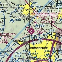
| Sectional chart |
|---|
|
CAUTION: Diagram may not be current

| Airport distance calculator |
|---|
|
|
| Sunrise and sunset |
|---|
|
Times for 05-Dec-2025
| | Local
(UTC-5) | | Zulu
(UTC) |
|---|
| Morning civil twilight | | 06:28 | | 11:28 |
| Sunrise | | 06:59 | | 11:59 |
| Sunset | | 16:14 | | 21:14 |
| Evening civil twilight | | 16:45 | | 21:45 |
|
| Current date and time |
|---|
| Zulu (UTC) | 05-Dec-2025 19:15:17 |
|---|
| Local (UTC-5) | 05-Dec-2025 14:15:17 |
|---|
|
| METAR |
|---|
| KSFZ | 051756Z AUTO 23004KT 10SM CLR M04/M18 A3021 RMK AO2 SLP239 T10441183 11039 21128 58034 FZRANO
|
KPVD
13nm S | 051851Z 15009KT 10SM BKN250 M04/M13 A3022 RMK AO2 SLP232 T10391128 $
|
KOQU
20nm S | 051850Z AUTO 18008KT 10SM CLR M03/M10 A3020 RMK A02
|
|
| TAF |
|---|
KPVD
13nm S | 051720Z 0518/0618 18005KT P6SM FEW030 FM052100 21004KT P6SM SCT025 FM060100 00000KT P6SM BKN030 FM061000 00000KT P6SM OVC020 PROB30 0610/0614 -SN
|
|
| NOTAMs |
|---|
NOTAMs are issued by the DoD/FAA and will open in a separate window not controlled by AirNav.
|
|


