FAA INFORMATION EFFECTIVE 12 JUNE 2025
Location
| FAA Identifier: | SPW |
| Lat/Long: | 43-09-56.3470N 095-12-10.0550W
43-09.939117N 095-12.167583W
43.1656519,-95.2027931
(estimated) |
| Elevation: | 1338.9 ft. / 408.1 m (surveyed) |
| Variation: | 05E (1985) |
| From city: | 3 miles NW of SPENCER, IA |
| Time zone: | UTC -5 (UTC -6 during Standard Time) |
| Zip code: | 51301 |
Airport Operations
| Airport use: | Open to the public |
| Activation date: | 03/1942 |
| Control tower: | no |
| ARTCC: | MINNEAPOLIS CENTER |
| FSS: | FORT DODGE FLIGHT SERVICE STATION |
| NOTAMs facility: | SPW (NOTAM-D service available) |
| Attendance: | SAT-SUN 0800-1700, ALL MON-FRI 0700-1900
FOR ATTENDANT AFTER HOURS CALL (712) 262-1000. |
| Wind indicator: | lighted |
| Segmented circle: | no |
| Lights: | ACTVT MIRL RYS 12/30 & 18/36; MALSR RY 12; VASI RYS 12 & 30; PAPI RYS 18 & 36; REIL RYS 30; 18 & 36 - CTAF. |
| Beacon: | white-green (lighted land airport)
Operates sunset to sunrise. |
Airport Communications
| CTAF/UNICOM: | 123.0 |
| WX ASOS: | 126.625 (712-262-8885) |
- APCH/DEP SVC PRVDD BY MINNEAPOLIS ARTCC ON FREQS 127.75/257.7 (FAIRMONT RCAG).
Nearby radio navigation aids
| VOR radial/distance | | VOR name | | Freq | | Var |
|---|
| SPW at field | | SPENCER VOR/DME | | 115.15 | | 05E |
| NDB name | | Hdg/Dist | | Freq | | Var | | ID |
|---|
| SNORE | | 122/6.8 | | 394 | | 05E | | SP | ... .--. |
Airport Services
| Fuel available: | 100LL JET-A |
| Parking: | hangars and tiedowns |
| Airframe service: | MAJOR |
| Powerplant service: | MAJOR |
Runway Information
Runway 12/30
| Dimensions: | 6001 x 100 ft. / 1829 x 30 m |
| Surface: | concrete, in fair condition |
| Weight bearing capacity: | | PCN 24 /R/B/W/U | | Single wheel: | 30.0 | | Double wheel: | 50.0 |
|
| Runway edge lights: | medium intensity |
| RUNWAY 12 | | RUNWAY 30 |
| Latitude: | 43-10.243437N | | 43-09.659308N |
| Longitude: | 095-12.729757W | | 095-11.641533W |
| Elevation: | 1338.7 ft. | | 1334.1 ft. |
| Traffic pattern: | left | | left |
| Runway heading: | 121 magnetic, 126 true | | 301 magnetic, 306 true |
| Displaced threshold: | no | | 490 ft. |
| Markings: | precision, in good condition | | nonprecision, in good condition |
| Visual slope indicator: | 4-box VASI on left (3.00 degrees glide path) | | 2-box VASI on left (3.00 degrees glide path) |
| Approach lights: | MALSR: 1,400 foot medium intensity approach lighting system with runway alignment indicator lights | | |
| Runway end identifier lights: | | | yes |
| Touchdown point: | yes, no lights | | yes, no lights |
| Instrument approach: | ILS | | |
| Obstructions: | none | | 15 ft. road, 750 ft. from runway, 36:1 slope to clear
APCH SLOPE 50:1 FROM DSPLCD THR. |
Runway 18/36
| Dimensions: | 5100 x 75 ft. / 1554 x 23 m |
| Surface: | concrete, in good condition |
| Weight bearing capacity: | | PCN 24 /R/B/W/U | | Single wheel: | 30.0 | | Double wheel: | 50.0 |
|
| Runway edge lights: | medium intensity |
| RUNWAY 18 | | RUNWAY 36 |
| Latitude: | 43-10.342408N | | 43-09.506932N |
| Longitude: | 095-12.090343W | | 095-12.202398W |
| Elevation: | 1334.9 ft. | | 1337.3 ft. |
| Traffic pattern: | left | | left |
| Runway heading: | 181 magnetic, 186 true | | 001 magnetic, 006 true |
| Markings: | nonprecision, in good condition | | nonprecision, in good condition |
| Visual slope indicator: | 4-light PAPI on left (3.00 degrees glide path) | | 4-light PAPI on left (3.00 degrees glide path) |
| Runway end identifier lights: | yes | | yes |
| Touchdown point: | yes, no lights | | yes, no lights |
| Obstructions: | none | | 18 ft. road, 560 ft. from runway, 20:1 slope to clear |
Airport Ownership and Management from official FAA records
| Ownership: | Publicly-owned |
| Owner: | CITY OF SPENCER
101 WEST 5TH STREET
SPENCER, IA 51301
Phone 712-580-7200 |
| Manager: | MARK WHITE
101 WEST 5TH STREET
SPENCER, IA 51301
Phone 712-262-1000 |
Additional Remarks
| - | WATERFOWL INVOF ARPT. |
| - | RY 12 IS CALM WIND RY. |
| - | FOR CD IF UNA TO CTC ON FSS FREQ, CTC MINNEAPOLIS ARTCC AT 651-463-5588. |
Instrument Procedures
NOTE: All procedures below are presented as PDF files. If you need a reader for these files, you should download the free Adobe Reader.NOT FOR NAVIGATION. Please procure official charts for flight.
FAA instrument procedures published for use from 12 June 2025 at 0901Z to 10 July 2025 at 0900z.
IAPs - Instrument Approach Procedures |
|---|
| ILS OR LOC RWY 12 | |
download (302KB) |
| RNAV (GPS) RWY 12 | |
download (285KB) |
| RNAV (GPS) RWY 18 | |
download (220KB) |
| RNAV (GPS) RWY 30 | |
download (248KB) |
| RNAV (GPS) RWY 36 | |
download (240KB) |
| VOR RWY 30 | |
download (219KB) |
| NOTE: Special Alternate Minimums apply | |
download (139KB) |
| NOTE: Special Take-Off Minimums/Departure Procedures apply **CHANGED** | |
download (429KB) |
Other nearby airports with instrument procedures:
4D8 - Fuller Airport (10 nm N)
KEGQ - Emmetsburg Municipal Airport (22 nm E)
KEST - Estherville Municipal Airport (25 nm NE)
KISB - Sibley Municipal Airport (27 nm NW)
KSHL - Sheldon Regional Airport (28 nm W)
|
|

Road maps at:
MapQuest
Bing
Google
| Aerial photo |
|---|
WARNING: Photo may not be current or correct
 Photo by Bryan A. Indrelie
Photo taken 07-Jul-2011
looking south.
Photo by Bryan A. Indrelie
Photo taken 07-Jul-2011
looking south.
Do you have a better or more recent aerial photo of Spencer Municipal Airport that you would like to share? If so, please send us your photo.
|
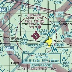
| Sectional chart |
|---|
|
| Airport distance calculator |
|---|
|
|
| Sunrise and sunset |
|---|
|
Times for 03-Jul-2025
| | Local
(UTC-5) | | Zulu
(UTC) |
|---|
| Morning civil twilight | | 05:12 | | 10:12 |
| Sunrise | | 05:47 | | 10:47 |
| Sunset | | 21:03 | | 02:03 |
| Evening civil twilight | | 21:38 | | 02:38 |
|
| Current date and time |
|---|
| Zulu (UTC) | 03-Jul-2025 06:21:45 |
|---|
| Local (UTC-5) | 03-Jul-2025 01:21:45 |
|---|
|
| METAR |
|---|
| KSPW | 030553Z AUTO 16005KT 10SM CLR 22/19 A2995 RMK AO2 SLP131 T02170194 10289 20217 403060161 50001
|
|
| NOTAMs |
|---|
NOTAMs are issued by the DoD/FAA and will open in a separate window not controlled by AirNav.
|
|


