FAA INFORMATION EFFECTIVE 16 APRIL 2026
Location
| FAA Identifier: | SSQ |
| Lat/Long: | 45-43-52.9730N 091-55-14.3840W
45-43.882883N 091-55.239733W
45.7313814,-91.9206622
(estimated) |
| Elevation: | 1233.3 ft. / 375.9 m (surveyed) |
| Variation: | 01E (2000) |
| From city: | 1 mile SE of SHELL LAKE, WI |
| Time zone: | UTC -5 (UTC -6 during Standard Time) |
| Zip code: | 54871 |
Airport Operations
| Airport use: | Open to the public |
| Control tower: | no |
| ARTCC: | MINNEAPOLIS CENTER |
| FSS: | GREEN BAY FLIGHT SERVICE STATION |
| NOTAMs facility: | GRB (NOTAM-D service available) |
| Attendance: | UNATNDD |
| Wind indicator: | lighted |
| Segmented circle: | yes |
| Lights: | MIRL RWY 14/32 PRESET TO LOW SS-SR; TO INCR INTST AND ACTVT REIL RWY 32; PAPI RWY 14, 32; MIRL RWY 14/32 - CTAF. |
| Beacon: | white-green (lighted land airport)
Operates sunset to sunrise. |
| Taxiway lights: | TWY LGTS AT ENTRANCE ONLY. |
Airport Communications
| CTAF/UNICOM: | 122.8 |
| WX AWOS-3PT at UBE (14 nm S): | 119.175 (715-822-3452) |
| WX AWOS-3 at RPD (20 nm S): | 120.525 (715-458-4481) |
| WX AWOS-3 at RZN (20 nm W): | 118.325 (715-349-8563) |
- APCH/DEP SVC PRVDD BY MINNEAPOLIS ARTCC ON FREQS 126.45/276.4 (HAYWARD RCAG).
Nearby radio navigation aids
| NDB name | | Hdg/Dist | | Freq | | Var | | ID |
|---|
| BIG DOCTOR | | 107/19.4 | | 203 | | 01W | | BXR | -... -..- .-. |
Airport Services
| Parking: | hangars and tiedowns |
| Airframe service: | NONE |
| Powerplant service: | NONE |
| Bottled oxygen: | NONE |
| Bulk oxygen: | NONE |
Runway Information
Runway 14/32
| Dimensions: | 3711 x 75 ft. / 1131 x 23 m |
| Surface: | asphalt, in good condition |
| Runway edge lights: | medium intensity |
| RUNWAY 14 | | RUNWAY 32 |
| Latitude: | 45-44.106725N | | 45-43.659018N |
| Longitude: | 091-55.536155W | | 091-54.943353W |
| Elevation: | 1232.0 ft. | | 1228.3 ft. |
| Traffic pattern: | left | | left |
| Runway heading: | 136 magnetic, 137 true | | 316 magnetic, 317 true |
| Displaced threshold: | 619 ft. | | 210 ft. |
| Declared distances: | TORA:3711 TODA:3711 ASDA:3500 LDA:2881 | | TORA:3286 TODA:3711 ASDA:3711 LDA:3500 |
| Markings: | nonprecision, in good condition | | nonprecision, in good condition |
| Visual slope indicator: | 2-light PAPI on left (4.00 degrees glide path) | | 2-light PAPI on left (3.00 degrees glide path) |
| Runway end identifier lights: | no | | yes |
| Touchdown point: | yes, no lights | | yes, no lights |
| Obstructions: | 95 ft. trees, lighted, 1080 ft. from runway, 400 ft. left of centerline, 9:1 slope to clear
RWY 14 APCH RATIO 18:1 TO DSPLCD THLD; 93 FT TREES 1699 FT 400 L. | | none |
Airport Ownership and Management from official FAA records
| Ownership: | Publicly-owned |
| Owner: | CITY OF SHELL LAKE
CITY HALL, P O BOX 520
SHELL LAKE, WI 54871
Phone 715-468-7679 |
| Manager: | GERRY WINCH
41 RIDGEWAY DR, P.O. BOX 520
SHELL LAKE, WI 54871
Phone (715) 296-3638 |
Additional Remarks
| - | BIRDS ON & INVOF OF ARPT. |
| - | FOR CD CTC MINNEAPOLIS ARTCC AT 651-463-5588. |
Instrument Procedures
NOTE: All procedures below are presented as PDF files. If you need a reader for these files, you should download the free Adobe Reader.NOT FOR NAVIGATION. Please procure official charts for flight.
FAA instrument procedures published for use from 16 April 2026 at 0901Z to 14 May 2026 at 0900Z.
IAPs - Instrument Approach Procedures |
|---|
| RNAV (GPS) RWY 14 | |
download (194KB) |
| RNAV (GPS) RWY 32 | |
download (198KB) |
| NOTE: Special Take-Off Minimums/Departure Procedures apply | |
download (201KB) |
Other nearby airports with instrument procedures:
KUBE - Cumberland Municipal Airport (14 nm S)
KRPD - Rice Lake Regional Airport - Carl's Field (20 nm S)
KRZN - Burnett County Airport (20 nm W)
KHYR - Sawyer County Airport (27 nm NE)
Y23 - Chetek Municipal/Southworth Airport (28 nm SE)
|
|

Road maps at:
MapQuest
Bing
Google
| Aerial photo |
|---|
WARNING: Photo may not be current or correct
 Photo by V. Eric Jensen, Shell Lake, WI
Photo taken 27-Aug-2003
Photo by V. Eric Jensen, Shell Lake, WI
Photo taken 27-Aug-2003
Do you have a better or more recent aerial photo of Shell Lake Municipal Airport that you would like to share? If so, please send us your photo.
|
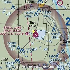
| Sectional chart |
|---|
|
| Airport distance calculator |
|---|
|
|
| Sunrise and sunset |
|---|
|
Times for 01-May-2026
| | Local
(UTC-5) | | Zulu
(UTC) |
|---|
| Morning civil twilight | | 05:23 | | 10:23 |
| Sunrise | | 05:56 | | 10:56 |
| Sunset | | 20:13 | | 01:13 |
| Evening civil twilight | | 20:46 | | 01:46 |
|
| Current date and time |
|---|
| Zulu (UTC) | 02-May-2026 03:46:09 |
|---|
| Local (UTC-5) | 01-May-2026 22:46:09 |
|---|
|
| METAR |
|---|
KUBE
14nm S | 020335Z AUTO 00000KT 10SM SCT100 06/M01 A3008 RMK AO2
|
KRPD
18nm SE | 020335Z AUTO 00000KT 10SM OVC100 04/M04 A3009 RMK AO2 T00441041
|
KRZN
19nm W | 020335Z AUTO 00000KT 10SM OVC100 03/M04 A3008 RMK AO2 T00261042
|
KHYR
26nm NE | 020253Z AUTO 00000KT 10SM BKN090 02/M04 A3007 RMK AO2 SLP196 T00221039 53008
|
|
| TAF |
|---|
KHYR
26nm NE | 011720Z 0118/0218 36007G15KT P6SM SCT050 FM020000 VRB02KT P6SM SKC FM021600 00000KT P6SM FEW050 FEW200
|
|
| NOTAMs |
|---|
NOTAMs are issued by the DoD/FAA and will open in a separate window not controlled by AirNav.
|
|

