FAA INFORMATION EFFECTIVE 14 MAY 2026
Location
| FAA Identifier: | T23 |
| Lat/Long: | 32-43-17.0000N 099-16-03.3000W
32-43.283333N 099-16.055000W
32.7213889,-99.2675833
(estimated) |
| Elevation: | 1414.8 ft. / 431.2 m (surveyed) |
| Variation: | 05E (2015) |
| From city: | 2 miles E of ALBANY, TX |
| Time zone: | UTC -5 (UTC -6 during Standard Time) |
| Zip code: | 76430 |
Airport Operations
| Airport use: | Open to the public |
| Activation date: | 07/1985 |
| Control tower: | no |
| ARTCC: | FORT WORTH CENTER |
| FSS: | FORT WORTH FLIGHT SERVICE STATION |
| NOTAMs facility: | FTW (NOTAM-D service available) |
| Attendance: | IREG |
| Wind indicator: | lighted |
| Segmented circle: | yes |
| Lights: | MIRL RWY 17/35 PRESET LOW INTST; TO INCR INTST AND ACTVT PAPI RWY 17 & 35 - 123.5. |
| Beacon: | white-green (lighted land airport)
Operates sunset to sunrise. |
Airport Communications
| CTAF: | 122.9 |
| ABILENE APPROACH: | 125.0 |
| ABILENE DEPARTURE: | 125.0 |
| WX AWOS-3 at BKD (19 nm E): | 120.175 (254-559-5525) |
Nearby radio navigation aids
| VOR radial/distance | | VOR name | | Freq | | Var |
|---|
| ABIr054/33.4 | | ABILENE VORTAC | | 113.70 | | 10E |
Airport Services
| Fuel available: | 100LL JET-A
100LL:100LL AND JET A 24 HRS SELF SERVE. |
| Parking: | tiedowns |
Runway Information
Runway 17/35
| Dimensions: | 5000 x 75 ft. / 1524 x 23 m |
| Surface: | asphalt, in excellent condition |
| Weight bearing capacity: | |
| Runway edge lights: | medium intensity |
| RUNWAY 17 | | RUNWAY 35 |
| Latitude: | 32-43.694867N | | 32-42.870675N |
| Longitude: | 099-16.068915W | | 099-16.040798W |
| Elevation: | 1386.0 ft. | | 1412.4 ft. |
| Traffic pattern: | left | | right |
| Runway heading: | 173 magnetic, 178 true | | 353 magnetic, 358 true |
| Markings: | nonprecision, in good condition | | nonprecision, in good condition |
| Visual slope indicator: | 2-light PAPI on left (3.00 degrees glide path) | | 2-light PAPI on left (3.00 degrees glide path) |
| Touchdown point: | yes, no lights | | yes, no lights |
| Obstructions: | 8 ft. road, 500 ft. from runway, 37:1 slope to clear
ALSO, 25 FT MKD PLINE, 990 FT DSTC, 0 FT B, APCH SLOPE 31:1. | | 10 ft. trees, marked, 512 ft. from runway, 160 ft. left of centerline, 31:1 slope to clear |
Airport Ownership and Management from official FAA records
| Ownership: | Publicly-owned |
| Owner: | THE CITY OF ALBANY
425 S SECOND ST, P O BOX 3248
ALBANY, TX 76430
Phone 325-762-3133 |
| Manager: | BILLY HOLSON
425 S SECOND ST, P O BOX 3248
ALBANY, TX 76430
Phone 325-762-0383
CITY/AIRPORT MGR. |
Additional Remarks
| - | FOR CD CTC FORT WORTH ARTCC AT 817-858-7584. |
Instrument Procedures
NOTE: All procedures below are presented as PDF files. If you need a reader for these files, you should download the free Adobe Reader.NOT FOR NAVIGATION. Please procure official charts for flight.
FAA instrument procedures published for use from 14 May 2026 at 0901Z to 11 June 2026 at 0900Z.
IAPs - Instrument Approach Procedures |
|---|
| RNAV (GPS) RWY 17 | |
download (214KB) |
| RNAV (GPS) RWY 35 | |
download (222KB) |
Other nearby airports with instrument procedures:
KBKD - Stephens County Airport (19 nm E)
KGZN - Gregory M Simmons Memorial Airport (25 nm SE)
F56 - Arledge Field Airport (26 nm NW)
KABI - Abilene Regional Airport (28 nm SW)
KETN - Eastland Municipal Airport (30 nm SE)
|
|

Road maps at:
MapQuest
Bing
Google
| Aerial photo |
|---|
WARNING: Photo may not be current or correct

Do you have a better or more recent aerial photo of Albany Municipal Airport that you would like to share? If so, please send us your photo.
|
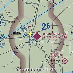
| Sectional chart |
|---|
|
| Airport distance calculator |
|---|
|
|
| Sunrise and sunset |
|---|
|
Times for 08-Jun-2026
| | Local
(UTC-5) | | Zulu
(UTC) |
|---|
| Morning civil twilight | | 06:01 | | 11:01 |
| Sunrise | | 06:30 | | 11:30 |
| Sunset | | 20:42 | | 01:42 |
| Evening civil twilight | | 21:11 | | 02:11 |
|
| Current date and time |
|---|
| Zulu (UTC) | 08-Jun-2026 09:11:42 |
|---|
| Local (UTC-5) | 08-Jun-2026 04:11:42 |
|---|
|
| METAR |
|---|
KBKD
19nm E | 080855Z AUTO 18007KT 5SM CLR 26/23 A2979 RMK AO2 T02560226
|
KGZN
25nm SE | 080855Z AUTO 18010G15KT 5SM BR 24/24 A2980 RMK AO2 FZRANO
|
KABI
28nm SW | 080852Z 16012KT 7SM CLR 25/22 A2981 RMK AO2 SLP065 T02500217 53003 PNO $
|
KETN
30nm SE | 080855Z AUTO 16009KT 7SM SCT026 24/22 A2982 RMK AO2 T02420223
|
KDYS
34nm SW | 080755Z AUTO 19012KT 10SM CLR 26/21 A2977 RMK AO2 SLP050 T02550205 $
|
|
| TAF |
|---|
KABI
28nm SW | 080529Z 0806/0906 18014G21KT P6SM FEW250 FM081400 19018G25KT P6SM FEW250 FM082200 17016G22KT P6SM FEW250
|
KDYS
34nm SW | 072045Z 0720/0822 19015G25KT 9999 SKC QNH2968INS BECMG 0810/0811 18015G25KT 9999 BKN020 QNH2981INS TEMPO 0811/0816 BKN010 BECMG 0817/0818 18012G18KT 9999 SKC QNH2983INS TX34/0722Z TN24/0812Z LAST NO AMDS AFT 0720 NEXT 0811
|
|
| NOTAMs |
|---|
NOTAMs are issued by the DoD/FAA and will open in a separate window not controlled by AirNav.
|
|

