FAA INFORMATION EFFECTIVE 19 MARCH 2026
Location
| FAA Identifier: | TLH |
| Lat/Long: | 30-23-48.3150N 084-21-03.1280W
30-23.805250N 084-21.052133W
30.3967542,-84.3508689
(estimated) |
| Elevation: | 83.1 ft. / 25.3 m (surveyed) |
| Variation: | 05W (2020) |
| From city: | 4 miles SW of TALLAHASSEE, FL |
| Time zone: | UTC -4 (UTC -5 during Standard Time) |
| Zip code: | 32310 |
Airport Operations
| Airport use: | Open to the public |
| Activation date: | 09/1961 |
| Control tower: | yes |
| ARTCC: | JACKSONVILLE CENTER |
| FSS: | GAINESVILLE FLIGHT SERVICE STATION |
| NOTAMs facility: | TLH (NOTAM-D service available) |
| Attendance: | CONTINUOUS |
| Wind indicator: | lighted |
| Segmented circle: | yes |
| Lights: | WHEN ATCT CLSD ACTVT MALSR 36; REIL RWY 9 & 18; PAPI RWY 9, 27, 18 & 36; HIRL RWY 9/27 & 18/36 - CTAF. ALSF2 RWY 27 PRESET ON MED INTST. |
| Beacon: | white-green (lighted land airport)
Operates sunset to sunrise. |
| Fire and rescue: | ARFF index C |
Airport Communications
| CTAF: | 118.7 |
| UNICOM: | 123.075 |
| ATIS: | 119.45 239.25 |
| WX ASOS: | 119.45 (850-203-0697) |
| TALLAHASSEE GROUND: | 121.9 348.6 [0600-2300] |
| TALLAHASSEE TOWER: | 118.7 257.8 [0600-2300] |
| TALLAHASSEE APPROACH: | 128.7 ;181-360 135.8 ;001-180 254.3 ;181-360 317.4 ;001-180 [0600-2300] |
| JACKSONVILLE ARTCC APPROACH: | 117.5T 133.85 354.1 [2300-0600] |
| TALLAHASSEE DEPARTURE: | 128.7 ;181-360 135.8 ;001-180 254.3 ;181-360 317.4 ;001-180 [0600-2300] |
| JACKSONVILLE ARTCC DEPARTURE: | 133.85 354.1 [2300-0600] |
| CLEARANCE DELIVERY: | 126.65 275.8 |
| CLASS C: | 128.7 ;181-360 135.8 ;001-180 254.3 ;181-360 317.4 ;001-180 |
| EMERG: | 121.5 243.0 |
| IC: | 135.8 ;001-180 317.4 ;001-180 |
| WX AWOS-3PT at 2J9 (16 nm NW): | 118.975 (850-627-6264) |
- APCH/DEP SVC PRVDD BY JACKSONVILLE ARTCC ON FREQS 128.625/379.175 (TALLAHASSEE RCAG) WHEN TALLAHASSEE APCH CTL CLSD.
Nearby radio navigation aids
| VOR radial/distance | | VOR name | | Freq | | Var |
|---|
| SZWr171/9.6 | | SEMINOLE VORTAC | | 117.50 | | 02E |
| GEFr251/30.8 | | GREENVILLE VORTAC | | 113.65 | | 01E |
| NDB name | | Hdg/Dist | | Freq | | Var | | ID |
|---|
| CAIDY | | 203/31.1 | | 338 | | 04W | | CYR | -.-. -.-- .-. |
| WILLIS | | 169/35.7 | | 359 | | 04W | | LYZ | .-.. -.-- --.. |
Airport Services
| Fuel available: | 100LL JET-A |
| Parking: | hangars and tiedowns |
| Airframe service: | MAJOR |
| Powerplant service: | MAJOR |
| Bottled oxygen: | HIGH |
| Bulk oxygen: | HIGH |
Runway Information
Runway 9/27
| Dimensions: | 8000 x 150 ft. / 2438 x 46 m |
| Surface: | asphalt/grooved, in good condition |
| Weight bearing capacity: | | Single wheel: | 120.0 | | Double wheel: | 231.0 | | Double tandem: | 445.0 | | Dual double tandem: | 920.0 |
|
| Runway edge lights: | high intensity |
| RUNWAY 9 | | RUNWAY 27 |
| Latitude: | 30-23.478593N | | 30-23.490670N |
| Longitude: | 084-21.392513W | | 084-19.870290W |
| Elevation: | 60.6 ft. | | 48.5 ft. |
| Traffic pattern: | left | | left |
| Runway heading: | 094 magnetic, 089 true | | 274 magnetic, 269 true |
| Markings: | precision, in good condition | | precision, in good condition |
| Visual slope indicator: | 4-light PAPI on left (3.00 degrees glide path) | | 4-light PAPI on left (3.00 degrees glide path) |
| RVR equipment: | touchdown, rollout | | touchdown, rollout |
| Approach lights: | | | ALSF2: standard 2,400 foot high intensity approach lighting system with centerline sequenced flashers (category II or III) |
| Runway end identifier lights: | yes | | |
| Centerline lights: | yes | | yes |
| Touchdown point: | yes, no lights | | yes, lighted |
| Instrument approach: | | | ILS/DME |
Runway 18/36
| Dimensions: | 7000 x 150 ft. / 2134 x 46 m |
| Surface: | asphalt/grooved, in excellent condition |
| Weight bearing capacity: | | Single wheel: | 120.0 | | Double wheel: | 217.0 | | Double tandem: | 410.0 | | Dual double tandem: | 862.0 |
|
| Runway edge lights: | high intensity |
| RUNWAY 18 | | RUNWAY 36 |
| Latitude: | 30-24.748970N | | 30-23.594215N |
| Longitude: | 084-21.538960W | | 084-21.527018W |
| Elevation: | 83.1 ft. | | 56.4 ft. |
| Traffic pattern: | left | | left |
| Runway heading: | 184 magnetic, 179 true | | 004 magnetic, 359 true |
| Markings: | precision, in fair condition | | precision, in fair condition |
| Visual slope indicator: | 4-light PAPI on left (3.00 degrees glide path) | | 4-light PAPI on left (3.00 degrees glide path) |
| RVR equipment: | rollout | | touchdown |
| Approach lights: | | | MALSR: 1,400 foot medium intensity approach lighting system with runway alignment indicator lights |
| Runway end identifier lights: | yes | | |
| Touchdown point: | yes, no lights | | yes, no lights |
| Instrument approach: | | | ILS/DME |
Airport Ownership and Management from official FAA records
| Ownership: | Publicly-owned |
| Owner: | CITY OF TALLAHASSEE
CITY HALL
TALLAHASSEE, FL 32304
Phone 850-891-7802 |
| Manager: | DAVID POLLARD
3300 CAPITAL CIRCLE SW
TALLAHASSEE, FL 32310
Phone 850-891-7802 |
Additional Remarks
| A39-18/36 | PCR VALUE: 490/F/A/X/T |
| A39-09/27 | PCR VALUE: 530/F/A/X/T |
| - | MOVEMENT AREA OF TWY 'Z' BEGINS AT THE INTXN OF TWY 'B8' & PROCEEDS E TO THE INTXN OF TWY 'B7' THIS TWY IS NOT FOR USE BY ACR OPNS; ASPH BTN TWYS 'B8' & 'A12' IS FOR HEL OPNS; TWY 'Z' FM TWY 'A12' TO THE RAMP IS OPEN TO ACFT WITH WINGSPAN OF 50 FT OR LESS. |
| - | BIRDS ON & INVOF ARPT. |
| - | FOR CD IF UNA TO CTC ON FSS FREQ, CTC TALLAHASSEE APCH AT 850-942-8311, WHEN APCH CLSD CTC JACKSONVILLE ARTCC AT 904-845-1592. |
| - | 24 HR PPR FOR ACFT EQUIPPED WITH WEATHER MODIFICATION OR GEOENGINEERING EQPT CTC ARPT COMMS CENTER AT 850-891-7830. |
Instrument Procedures
NOTE: All procedures below are presented as PDF files. If you need a reader for these files, you should download the free Adobe Reader.NOT FOR NAVIGATION. Please procure official charts for flight.
FAA instrument procedures published for use from 19 March 2026 at 0901Z to 16 April 2026 at 0900Z.
IAPs - Instrument Approach Procedures |
|---|
| HI-ILS Y OR LOC Y RWY 36 | |
download (175KB) |
| ILS OR LOC RWY 27 | |
download (290KB) |
| ILS Z OR LOC Z RWY 36 | |
download (266KB) |
| ILS RWY 27 (CAT II) | |
download (249KB) |
| RNAV (GPS) RWY 09 | |
download (252KB) |
| RNAV (GPS) RWY 18 | |
download (256KB) |
| RNAV (GPS) RWY 27 | |
download (247KB) |
| RNAV (GPS) RWY 36 | |
download (269KB) |
| VOR RWY 18 | |
download (251KB) |
| HI-VOR OR TACAN RWY 36 | |
download (166KB) |
| VOR OR TACAN RWY 36 | |
download (253KB) |
| Radar Approach Procedures available | |
download (176KB) |
| NOTE: Special Alternate Minimums apply | |
download (147KB) |
| NOTE: Special Take-Off Minimums/Departure Procedures apply | |
download (234KB) |
Other nearby airports with instrument procedures:
2J9 - Quincy Municipal Airport (16 nm NW)
70J - Cairo-Grady County Airport (31 nm N)
KBGE - Decatur County Industrial Air Park (38 nm NW)
KTVI - Thomasville Regional Airport (39 nm NE)
KFPY - Perry-Foley Airport (44 nm SE)
|
|

Road maps at:
MapQuest
Bing
Google
| Aerial photo |
|---|
WARNING: Photo may not be current or correct
 Photo courtesy of seriouslyfunny photography
Taken in April 2007
Photo courtesy of seriouslyfunny photography
Taken in April 2007
Do you have a better or more recent aerial photo of Tallahassee International Airport that you would like to share? If so, please send us your photo.
|
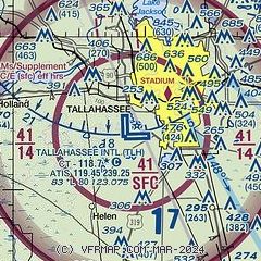
| Sectional chart |
|---|
|
CAUTION: Diagram may not be current
 Download PDF
of official airport diagram from the FAA
| Airport distance calculator |
|---|
|
|
| Sunrise and sunset |
|---|
|
Times for 22-Mar-2026
| | Local
(UTC-4) | | Zulu
(UTC) |
|---|
| Morning civil twilight | | 07:16 | | 11:16 |
| Sunrise | | 07:40 | | 11:40 |
| Sunset | | 19:49 | | 23:49 |
| Evening civil twilight | | 20:13 | | 00:13 |
|
| Current date and time |
|---|
| Zulu (UTC) | 22-Mar-2026 18:51:55 |
|---|
| Local (UTC-4) | 22-Mar-2026 14:51:55 |
|---|
|
| METAR |
|---|
| KTLH | 221753Z 23010KT 10SM FEW043 27/14 A3007 RMK AO2 SLP180 T02720139 10272 20117 58012 $
|
K2J9
16nm NW | 221835Z AUTO 21008KT 190V250 10SM CLR 29/15 A3006 RMK AO2
|
|
| TAF |
|---|
| KTLH | 221720Z 2218/2318 26009G15KT P6SM SCT030 FM230000 23004KT P6SM FEW250 FM230900 00000KT 3SM BR BKN005 FM231500 28011KT P6SM SCT020
|
|
| NOTAMs |
|---|
NOTAMs are issued by the DoD/FAA and will open in a separate window not controlled by AirNav.
|
|


