FAA INFORMATION EFFECTIVE 27 NOVEMBER 2025
Location
| FAA Identifier: | TVI |
| Lat/Long: | 30-54-05.3000N 083-52-53.2000W
30-54.088333N 083-52.886667W
30.9014722,-83.8814444
(estimated) |
| Elevation: | 263.6 ft. / 80.3 m (surveyed) |
| Variation: | 05W (2020) |
| From city: | 6 miles NE of THOMASVILLE, GA |
| Time zone: | UTC -5 (UTC -4 during Daylight Saving Time) |
| Zip code: | 31757 |
Airport Operations
| Airport use: | Open to the public |
| Activation date: | 04/1943 |
| Control tower: | no |
| ARTCC: | JACKSONVILLE CENTER |
| FSS: | MACON FLIGHT SERVICE STATION |
| NOTAMs facility: | MCN (NOTAM-D service available) |
| Attendance: | MON-FRI 0600-2000, ALL SAT-SUN 0700-1900 |
| Wind indicator: | lighted |
| Segmented circle: | no |
| Lights: | HIRL RWY 04/22 PRESET LOW INTST; TO INCR INTST & ACTVT MALSF - CTAF. ACTVT PAPI RWY 04 & 22, 32 DURG DALGT HRS - CTAF. AFTER DUSK PAPI RWY 04 & 22, 32 OPR CONSLY. |
| Beacon: | white-green (lighted land airport)
Operates sunset to sunrise. |
Airport Communications
| CTAF/UNICOM: | 123.075 |
| WX AWOS-3PT: | 119.175 (229-225-4336) |
| VALDOSTA APPROACH: | 126.6 ;EAST OF VAD 360-VAD 180 132.375 ;WEST OF VAD R-360 RADIAL [0600-0000] |
| VALDOSTA DEPARTURE: | 126.6 ;EAST OF VAD 360-VAD 180 132.375 ;WEST OF VAD R-360 RADIAL [0600-0000] |
| IC: | 126.6 ;EAST OF VAD 360-VAD 180 |
| WX AWOS-3PT at MGR (12 nm N): | 118.925 (229-890-5320) |
- APCH/DEP SVC PRVDD BY JACKSONVILLE ARTCC ON FREQS 125.75/363.075 (ALBANY RCAG) WHEN VALDOSTA APCH CTL CLSD.
Nearby radio navigation aids
| VOR radial/distance | | VOR name | | Freq | | Var |
|---|
| GEFr345/21.6 | | GREENVILLE VORTAC | | 113.65 | | 01E |
| OTKr285/31.8 | | VALDOSTA VOR/DME | | 114.80 | | 02W |
| SZWr049/32.8 | | SEMINOLE VORTAC | | 117.50 | | 02E |
| NDB name | | Hdg/Dist | | Freq | | Var | | ID |
|---|
| PATON | | 225/4.4 | | 245 | | 05W | | GTP | --. - .--. |
| CAIDY | | 091/14.3 | | 338 | | 04W | | CYR | -.-. -.-- .-. |
| WILLIS | | 101/33.4 | | 359 | | 04W | | LYZ | .-.. -.-- --.. |
Airport Services
| Fuel available: | 100LL JET-A JET-A+ |
| Parking: | hangars and tiedowns |
| Airframe service: | MAJOR |
| Powerplant service: | MAJOR |
| Bottled oxygen: | NONE |
| Bulk oxygen: | NONE |
Runway Information
Runway 4/22
| Dimensions: | 6004 x 101 ft. / 1830 x 31 m |
| Surface: | asphalt, in good condition |
| Weight bearing capacity: | |
| Runway edge lights: | high intensity |
| RUNWAY 4 | | RUNWAY 22 |
| Latitude: | 30-53.648947N | | 30-54.409105N |
| Longitude: | 083-53.314732W | | 083-52.578585W |
| Elevation: | 238.2 ft. | | 230.0 ft. |
| Traffic pattern: | left | | left |
| Runway heading: | 045 magnetic, 040 true | | 225 magnetic, 220 true |
| Displaced threshold: | 506 ft. | | no |
| Declared distances: | TORA:6004 TODA:6004 ASDA:6004 LDA:5498 | | TORA:6004 TODA:6004 ASDA:5504 LDA:5504 |
| Markings: | nonprecision, in good condition | | precision, in good condition |
| Visual slope indicator: | 4-light PAPI on left (3.00 degrees glide path) | | 4-light PAPI on left (3.00 degrees glide path) |
| Approach lights: | | | MALSF: 1,400 foot medium intensity approach lighting system with sequenced flashers |
| Runway end identifier lights: | no | | no |
| Touchdown point: | yes, no lights | | yes, no lights |
| Instrument approach: | | | ILS/DME |
| Obstructions: | none
OBST CLNC SLOPE 20:1 TO DTHR. | | 114 ft. trees, 2366 ft. from runway, 778 ft. left of centerline, 19:1 slope to clear |
Runway 14/32
| Dimensions: | 4999 x 100 ft. / 1524 x 30 m |
| Surface: | asphalt, in good condition |
| Weight bearing capacity: | |
| Runway edge lights: | low intensity |
| RUNWAY 14 | | RUNWAY 32 |
| Latitude: | 30-54.440810N | | 30-53.876815N |
| Longitude: | 083-53.163813W | | 083-52.466228W |
| Elevation: | 263.6 ft. | | 249.6 ft. |
| Traffic pattern: | left | | left |
| Runway heading: | 138 magnetic, 133 true | | 318 magnetic, 313 true |
| Markings: | nonprecision, in good condition | | nonprecision, in good condition |
| Visual slope indicator: | | | 4-light PAPI on left (3.00 degrees glide path) |
| Touchdown point: | yes, no lights | | yes, no lights |
| Obstructions: | 72 ft. trees, 1280 ft. from runway, 253 ft. right of centerline, 15:1 slope to clear | | none |
Airport Ownership and Management from official FAA records
| Ownership: | Publicly-owned |
| Owner: | CITY OF THOMASVILLE
PO BOX 1540
THOMASVILLE, GA 31799
Phone 229-227-3262 |
| Manager: | ROBERT PETTY
882 AIRPORT RD
THOMASVILLE, GA 31757
Phone 229-225-4313 |
Additional Remarks
| - | TWYS ON APRON SIDE OF RWYS LGTD. |
Instrument Procedures
NOTE: All procedures below are presented as PDF files. If you need a reader for these files, you should download the free Adobe Reader.NOT FOR NAVIGATION. Please procure official charts for flight.
FAA instrument procedures published for use from 27 November 2025 at 0901Z to 25 December 2025 at 0900Z.
IAPs - Instrument Approach Procedures |
|---|
| RNAV (GPS) RWY 04 **CHANGED** | |
download (223KB) |
| RNAV (GPS) RWY 22 **CHANGED** | |
download (285KB) |
| NDB RWY 22 **CHANGED** | |
download (235KB) |
| NOTE: Special Alternate Minimums apply | |
download (159KB) |
| NOTE: Special Take-Off Minimums/Departure Procedures apply | |
download (497KB) |
Other nearby airports with instrument procedures:
KMGR - Moultrie Municipal Airport (12 nm N)
70J - Cairo-Grady County Airport (14 nm W)
4J5 - Quitman Brooks County Airport (16 nm E)
KCXU - Camilla-Mitchell County Airport (26 nm NW)
15J - Cook County Airport (26 nm NE)
|
|

Road maps at:
MapQuest
Bing
Google
| Aerial photo |
|---|
WARNING: Photo may not be current or correct
 Photo taken 15-Sep-2012
looking northeast.
Photo taken 15-Sep-2012
looking northeast.
Do you have a better or more recent aerial photo of Thomasville Regional Airport that you would like to share? If so, please send us your photo.
|
| Sectional chart |
|---|
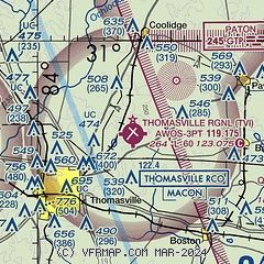
|
| Airport distance calculator |
|---|
|
|
| Sunrise and sunset |
|---|
|
Times for 10-Dec-2025
| | Local
(UTC-5) | | Zulu
(UTC) |
|---|
| Morning civil twilight | | 06:57 | | 11:57 |
| Sunrise | | 07:24 | | 12:24 |
| Sunset | | 17:33 | | 22:33 |
| Evening civil twilight | | 18:00 | | 23:00 |
|
| Current date and time |
|---|
| Zulu (UTC) | 11-Dec-2025 00:34:51 |
|---|
| Local (UTC-5) | 10-Dec-2025 19:34:51 |
|---|
|
| METAR |
|---|
| KTVI | 110015Z AUTO 22003KT 10SM CLR 11/06 A2991 RMK AO2
|
KMGR
12nm N | 110015Z AUTO 23005KT 10SM CLR 12/07 A2990 RMK AO2 T01240066 $
|
|
| TAF |
|---|
KVLD
33nm E | 101720Z 1018/1118 24005KT P6SM SKC FM110200 23004KT P6SM SCT030 FM110700 34004KT P6SM SKC
|
KVAD
35nm E | 101700Z 1017/1123 24009KT 9999 SKC QNH2989INS BECMG 1101/1102 27012KT 9999 SCT025 QNH2989INS BECMG 1107/1108 29012KT 9999 BKN015 QNH2994INS BECMG 1111/1112 31009KT 9999 SCT025 QNH3000INS BECMG 1115/1116 32009KT 9999 SKC QNH3005INS BECMG 1121/1122 26006KT 9999 FEW150 QNH3006INS TX16/1019Z TN04/1110Z
|
KTLH
39nm SW | 101720Z 1018/1118 27009KT P6SM SKC FM102300 26011KT P6SM SCT030 FM110600 33007KT P6SM SKC
|
|
| NOTAMs |
|---|
NOTAMs are issued by the DoD/FAA and will open in a separate window not controlled by AirNav.
|
|


