FAA INFORMATION EFFECTIVE 17 APRIL 2025
Location
| FAA Identifier: | XVG |
| Lat/Long: | 46-59-23.6670N 094-12-13.0750W
46-59.394450N 094-12.217917W
46.9899075,-94.2036319
(estimated) |
| Elevation: | 1336.8 ft. / 407.5 m (surveyed) |
| Variation: | 03E (2000) |
| From city: | 1 mile NE of LONGVILLE, MN |
| Time zone: | UTC -5 (UTC -6 during Standard Time) |
| Zip code: | 56655 |
Airport Operations
| Airport use: | Open to the public |
| Activation date: | 07/1958 |
| Control tower: | no |
| ARTCC: | MINNEAPOLIS CENTER |
| FSS: | PRINCETON FLIGHT SERVICE STATION |
| NOTAMs facility: | XVG (NOTAM-D service available) |
| Attendance: | UNATNDD |
| Wind indicator: | lighted |
| Segmented circle: | no |
| Lights: | ACTVT PAPI RWY 13 & 31; MIRL RWY 13/31 - CTAF. |
| Beacon: | white-green (lighted land airport)
Operates sunset to sunrise. |
Airport Communications
| CTAF: | 122.9 |
| WX AWOS-3: | 118.275 (218-363-3347) |
| WX AWOS-3 at PWC (18 nm SW): | 118.525 (218-587-3420) |
- APCH/DEP SVC PRVDD BY MINNEAPOLIS ARTCC ON FREQS 118.05/239.0 (BRAINERD RCAG).
Nearby radio navigation aids
| VOR radial/distance | | VOR name | | Freq | | Var |
|---|
| GPZr244/31.0 | | GRAND RAPIDS VOR/DME | | 111.40 | | 06E |
Airport Services
| Fuel available: | 100LL
100LL:FUEL AVBL H24 SELF SVC VIA CREDIT CARD. |
| Parking: | tiedowns |
Runway Information
Runway 13/31
| Dimensions: | 3549 x 75 ft. / 1082 x 23 m |
| Surface: | asphalt, in good condition |
| Weight bearing capacity: | | Single wheel: | 12.5 | | Double wheel: | 14.0 |
|
| Runway edge lights: | medium intensity |
| RUNWAY 13 | | RUNWAY 31 |
| Latitude: | 46-59.612417N | | 46-59.176470N |
| Longitude: | 094-12.501703W | | 094-11.934160W |
| Elevation: | 1334.6 ft. | | 1330.8 ft. |
| Traffic pattern: | left | | left |
| Runway heading: | 135 magnetic, 138 true | | 315 magnetic, 318 true |
| Displaced threshold: | 440 ft. | | no |
| Declared distances: | TORA:3549 TODA:3549 ASDA:3549 LDA:3109 | | TORA:3549 TODA:3549 ASDA:3549 LDA:3549 |
| Markings: | nonprecision, in good condition | | nonprecision, in good condition |
| Visual slope indicator: | 4-light PAPI on left (4.00 degrees glide path) | | 4-light PAPI on left (4.00 degrees glide path) |
| Runway end identifier lights: | no | | no |
| Touchdown point: | yes, no lights | | yes, no lights |
| Obstructions: | 20 ft. road, 334 ft. from runway, 250 ft. right of centerline, 6:1 slope to clear | | 9 ft. brush, 201 ft. from runway, 179 ft. right of centerline, 1:1 slope to clear |
Airport Ownership and Management from official FAA records
| Ownership: | Publicly-owned |
| Owner: | CITY OF LONGVILLE
PO BOX 217
LONGVILLE, MN 56655-0217
Phone 218-363-2022 |
| Manager: | CHRISTINA HERHEIM
PO BOX 217
LONGVILLE, MN 56655-0217
Phone 218-363-2022 |
Additional Remarks
| - | DEER & BIRDS ON & INVOF ARPT. |
| - | GCO AVBL ON FREQ 121.725 THRU MINNEAPOLIS ARTCC & PRINCETON FSS. |
| - | FOR CD IF UNA VIA GCO CTC MINNEAPOLIS ARTCC AT 651-463-5588. |
Instrument Procedures
NOTE: All procedures below are presented as PDF files. If you need a reader for these files, you should download the free Adobe Reader.NOT FOR NAVIGATION. Please procure official charts for flight.
FAA instrument procedures published for use from 17 April 2025 at 0901Z to 15 May 2025 at 0900z.
IAPs - Instrument Approach Procedures |
|---|
| RNAV (GPS) RWY 13 | |
download (221KB) |
| RNAV (GPS) RWY 31 | |
download (235KB) |
| NOTE: Special Alternate Minimums apply | |
download (158KB) |
| NOTE: Special Take-Off Minimums/Departure Procedures apply | |
download (440KB) |
Other nearby airports with instrument procedures:
KPWC - Pine River Regional Airport (18 nm SW)
Y49 - Walker Municipal Airport (21 nm NW)
KGPZ - Grand Rapids/Itasca County Airport-Gordon Newstrom Field (31 nm NE)
KAIT - Aitkin Municipal Airport - Steve Kurtz Field (34 nm SE)
KBRD - Brainerd Lakes Regional Airport (35 nm S)
|
|

Road maps at:
MapQuest
Bing
Google
| Aerial photo |
|---|
WARNING: Photo may not be current or correct
 Photo by Ted Sigtenhorst
Photo taken 05-Jun-2009
from a a 1974 V35B Bonanza.
Photo by Ted Sigtenhorst
Photo taken 05-Jun-2009
from a a 1974 V35B Bonanza.
Do you have a better or more recent aerial photo of Longville Municipal Airport that you would like to share? If so, please send us your photo.
|
| Sectional chart |
|---|
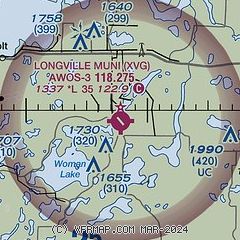
|
| Airport distance calculator |
|---|
|
|
| Sunrise and sunset |
|---|
|
Times for 09-May-2025
| | Local
(UTC-5) | | Zulu
(UTC) |
|---|
| Morning civil twilight | | 05:15 | | 10:15 |
| Sunrise | | 05:50 | | 10:50 |
| Sunset | | 20:36 | | 01:36 |
| Evening civil twilight | | 21:11 | | 02:11 |
|
| Current date and time |
|---|
| Zulu (UTC) | 09-May-2025 12:59:17 |
|---|
| Local (UTC-5) | 09-May-2025 07:59:17 |
|---|
|
| METAR |
|---|
| KXVG | 091253Z AUTO 21007KT 10SM CLR 15/M01 A3011 RMK AO2
|
KPWC
18nm S | 091235Z AUTO 15003KT 10SM CLR 12/04 A3016 RMK AO2
|
|
| TAF |
|---|
KBRD
36nm S | 091135Z 0912/1012 20007KT P6SM SKC FM091800 31008G15KT P6SM SCT100 FM092200 34009G16KT P6SM SKC FM100200 34008KT P6SM SKC
|
KBJI
42nm NW | 091134Z 0912/1012 21009KT P6SM BKN120 FM091500 30010KT P6SM BKN120 FM091700 34012KT P6SM SCT100 FM101100 00000KT P6SM SKC
|
|
| NOTAMs |
|---|
NOTAMs are issued by the DoD/FAA and will open in a separate window not controlled by AirNav.
|
|


