FAA INFORMATION EFFECTIVE 16 APRIL 2026
Location
| FAA Identifier: | Y83 |
| Lat/Long: | 43-27-20.2882N 082-50-30.4123W
43-27.338137N 082-50.506872W
43.4556356,-82.8417812
(estimated) |
| Elevation: | 776.9 ft. / 236.8 m (surveyed) |
| Variation: | 08W (2025) |
| From city: | 3 miles N of SANDUSKY, MI |
| Time zone: | UTC -4 (UTC -5 during Standard Time) |
| Zip code: | 48471 |
Airport Operations
| Airport use: | Open to the public |
| Activation date: | 12/1961 |
| Control tower: | no |
| ARTCC: | CLEVELAND CENTER |
| FSS: | LANSING FLIGHT SERVICE STATION |
| NOTAMs facility: | LAN (NOTAM-D service available) |
| Attendance: | MON-FRI 0900-1630, ALL SAT-SUN ON CALL
FOR SVC AFT HRS CALL AMGR. |
| Wind indicator: | lighted |
| Segmented circle: | yes |
| Lights: | ACTVT MIRL RWY 10/28 - CTAF. |
| Beacon: | white-green (lighted land airport)
Operates sunset to sunrise. |
Airport Communications
- APCH/DEP SVC PRVDD BY CLEVELAND ARTCC (ZOB) ON FREQS 127.7/290.425 (FREELAND RCAG).
Airport Services
| Fuel available: | 100LL |
| Parking: | hangars and tiedowns |
| Airframe service: | MAJOR |
| Powerplant service: | MAJOR |
| Bottled oxygen: | NONE |
| Bulk oxygen: | NONE |
Runway Information
Runway 10/28
| Dimensions: | 3499 x 75 ft. / 1066 x 23 m |
| Surface: | asphalt, in excellent condition |
| Weight bearing capacity: | |
| Runway edge lights: | medium intensity |
| RUNWAY 10 | | RUNWAY 28 |
| Latitude: | 43-27.416140N | | 43-27.427003N |
| Longitude: | 082-50.853413W | | 082-50.062918W |
| Elevation: | 776.3 ft. | | 774.4 ft. |
| Traffic pattern: | left | | left |
| Runway heading: | 097 magnetic, 089 true | | 277 magnetic, 269 true |
| Markings: | nonprecision, in good condition | | nonprecision, in good condition |
| Visual slope indicator: | 2-light PAPI on left (3.00 degrees glide path) | | 2-light PAPI on left (3.00 degrees glide path) |
| Runway end identifier lights: | yes | | no |
| Touchdown point: | yes, no lights | | yes, no lights |
Runway 18/36
| Dimensions: | 2271 x 153 ft. / 692 x 47 m |
| Surface: | turf, in good condition |
| Runway edge markings: | 3 FT YELLOW CONES. |
| RUNWAY 18 | | RUNWAY 36 |
| Latitude: | 43-27.394298N | | 43-27.020457N |
| Longitude: | 082-50.582705W | | 082-50.576540W |
| Elevation: | 774.4 ft. | | 772.8 ft. |
| Traffic pattern: | left | | left |
| Runway heading: | 187 magnetic, 179 true | | 007 magnetic, 359 true |
| Displaced threshold: | no | | 374 ft. |
| Touchdown point: | yes, no lights | | yes, no lights |
| Obstructions: | none | | 17 ft. road, 58 ft. from runway, 125 ft. left and right of centerline, 3:1 slope to clear
APCH RATIO 6:1 TO DTHR OVR 63 FT TREE, 380 FT DIST, 150 FT R. |
Airport Ownership and Management from official FAA records
| Ownership: | Publicly-owned |
| Owner: | CITY OF SANDUSKY
26 W SPEAKER ST
SANDUSKY, MI 48471-1299
Phone 810-648-4444 |
| Manager: | DON JOHNSTON
CITY HALL, 26 W SPEAKER ST
SANDUSKY, MI 48471-1299
Phone 810-414-3009 |
Additional Remarks
| - | +3 FT EMBANKMENT, 50 FT FM RWY 36 THR; -10 FT DITCH, 100 FT EAST OF RWY 18/36. |
| - | DEER & LRG BIRDS ON & INVOF ARPT. |
| - | FOR CD CTC CLEVELAND ARTCC AT 440-774-0224/0490. |
| - | FOR AFT HRS ACES TO TRML BLDG CALL AMGR. |
Instrument Procedures
NOTE: All procedures below are presented as PDF files. If you need a reader for these files, you should download the free Adobe Reader.NOT FOR NAVIGATION. Please procure official charts for flight.
FAA instrument procedures published for use from 16 April 2026 at 0901Z to 14 May 2026 at 0900Z.
IAPs - Instrument Approach Procedures |
|---|
| RNAV (GPS) RWY 10 **CHANGED** | |
download (200KB) |
| RNAV (GPS) RWY 28 **CHANGED** | |
download (199KB) |
| NOTE: Special Take-Off Minimums/Departure Procedures apply | |
download (355KB) |
Other nearby airports with instrument procedures:
77G - Marlette Township Airport (14 nm SW)
KBAX - Huron County Memorial Airport (20 nm N)
KCFS - Tuscola Area Airport (26 nm W)
D95 - Dupont/Lapeer Airport (30 nm SW)
KPHN - St Clair County International Airport (35 nm SE)
|
|

Road maps at:
MapQuest
Bing
Google
| Aerial photo |
|---|
WARNING: Photo may not be current or correct
 Photo taken 16-Oct-2010
looking northeast.
Photo taken 16-Oct-2010
looking northeast.
Do you have a better or more recent aerial photo of Sandusky City Airport that you would like to share? If so, please send us your photo.
|
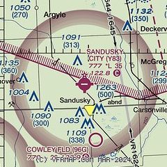
| Sectional chart |
|---|
|
| Airport distance calculator |
|---|
|
|
| Sunrise and sunset |
|---|
|
Times for 21-Apr-2026
| | Local
(UTC-4) | | Zulu
(UTC) |
|---|
| Morning civil twilight | | 06:10 | | 10:10 |
| Sunrise | | 06:40 | | 10:40 |
| Sunset | | 20:20 | | 00:20 |
| Evening civil twilight | | 20:50 | | 00:50 |
|
| Current date and time |
|---|
| Zulu (UTC) | 21-Apr-2026 10:38:55 |
|---|
| Local (UTC-4) | 21-Apr-2026 06:38:55 |
|---|
|
| METAR |
|---|
KBAX
21nm N | 211015Z AUTO 18011G18KT 10SM SCT120 03/M01 A3012 RMK AO2 T00301010
|
KCFS
26nm W | 211015Z AUTO 17009KT 10SM FEW120 05/M03 A3012 RMK AO2
|
KD95
30nm SW | 211015Z AUTO 17006KT 10SM CLR 05/M02 A3016 RMK AO2
|
KP58
34nm N | 210955Z AUTO 16008G19KT 03/M01 A3010 RMK AO1 SLP202 T00331011 PNO $
|
KPHN
35nm SE | 211016Z AUTO 15007KT 10SM SCT120 03/M02 A3020 RMK AO2
|
CYZR
36nm SE | 211000Z AUTO 17011G16KT 9SM OVC120 03/M02 A3019 RMK SLP232
|
|
| TAF |
|---|
CYZR
36nm SE | 210740Z 2108/2120 17008KT P6SM BKN130 BECMG 2110/2112 17015KT FM211400 19015G25KT P6SM BKN060 FM211800 20015G25KT P6SM SCT060 RMK FCST BASED ON AUTO OBS. NXT FCST BY 211400Z
|
|
| NOTAMs |
|---|
NOTAMs are issued by the DoD/FAA and will open in a separate window not controlled by AirNav.
|
|

