FAA INFORMATION EFFECTIVE 17 APRIL 2025
Location
| FAA Identifier: | B19 |
| Lat/Long: | 43-27-50.8000N 070-28-20.6000W
43-27.846667N 070-28.343333W
43.4641111,-70.4723889
(estimated) |
| Elevation: | 157 ft. / 47.9 m (surveyed) |
| Variation: | 17W (2000) |
| From city: | 2 miles S of BIDDEFORD, ME |
| Time zone: | UTC -4 (UTC -5 during Standard Time) |
| Zip code: | 04005 |
Airport Operations
| Airport use: | Open to the public |
| Activation date: | 04/1940 |
| Control tower: | no |
| ARTCC: | BOSTON CENTER |
| FSS: | BANGOR FLIGHT SERVICE STATION |
| NOTAMs facility: | BGR (NOTAM-D service available) |
| Attendance: | MON-THUR 1000-1600, ALL SAT-SUN 0900-1600 |
| Pattern altitude: | 995 ft. MSL |
| Wind indicator: | lighted |
| Segmented circle: | no |
| Lights: | ACTVT REIL RWY 06; PAPI RWY 06; MIRL RWY 06/24 - CTAF. |
| Beacon: | white-green (lighted land airport)
Operates sunset to sunrise. |
Airport Communications
| CTAF/UNICOM: | 123.0 |
| PORTLAND APPROACH: | 119.75 |
| PORTLAND DEPARTURE: | 119.75 |
| WX AWOS-3PT at SFM (11 nm W): | 120.025 (207-324-1958) |
| WX ASOS at PWM (13 nm NE): | 119.05 (207-874-7914) |
- APCH/DEP SVC PRVDD BY BOSTON ARTCC ON FREQ 128.2/263.05 (WATERBORO RCAG) WHEN PORTLAND ATCT CLSD.
Nearby radio navigation aids
| VOR radial/distance | | VOR name | | Freq | | Var |
|---|
| ENEr086/6.6 | | KENNEBUNK VOR/DME | | 117.10 | | 17W |
| NDB name | | Hdg/Dist | | Freq | | Var | | ID |
|---|
| ROLLINS | | 063/21.3 | | 260 | | 16W | | ESG | . ... --. |
Airport Services
| Fuel available: | 100LL
100LL:24 HR FUEL W/MAJOR CREDIT CARD - SELF SVC. |
| Parking: | hangars and tiedowns |
| Airframe service: | NONE |
| Powerplant service: | NONE |
| Bottled oxygen: | NONE |
| Bulk oxygen: | NONE |
Runway Information
Runway 6/24
| Dimensions: | 3000 x 75 ft. / 914 x 23 m |
| Surface: | asphalt, in excellent condition |
| Weight bearing capacity: | |
| Runway edge lights: | medium intensity |
| RUNWAY 6 | | RUNWAY 24 |
| Latitude: | 43-27.659833N | | 43-28.033850N |
| Longitude: | 070-28.565167W | | 070-28.122600W |
| Elevation: | 146.5 ft. | | 154.8 ft. |
| Traffic pattern: | left | | left |
| Runway heading: | 058 magnetic, 041 true | | 238 magnetic, 221 true |
| Markings: | nonprecision, in good condition | | basic, in good condition |
| Visual slope indicator: | 4-light PAPI on left (3.50 degrees glide path) | | |
| Runway end identifier lights: | yes | | no |
| Touchdown point: | yes, no lights | | yes, no lights |
| Obstructions: | 6 ft. brush, 220 ft. from runway, 115 ft. right of centerline, 3:1 slope to clear
7 FT BRUSH 78 FT FM THR, 151 FT R OF CNTRLN; 5 FT BRUSH 114 FT FM THR, 166 FT L OF CNTRLN. | | 3 ft. brush, 204 ft. from runway, 130 ft. right of centerline, 1:1 slope to clear
+6-8 FT BRUSH & ROCK LEDGE 10-55 FT FM THR, 228 FT R OF CNTRLN. |
Airport Ownership and Management from official FAA records
| Ownership: | Publicly-owned |
| Owner: | CITY OF BIDDEFORD
BOX 586 205 MAIN ST.
BIDDEFORD, ME 04005
Phone 207-284-9307 |
| Manager: | JEFF DEMERS
371 HILL STREET
BIDDEFORD, ME 04005
Phone 207-282-1579
PUB WORKS DEPT. |
Additional Remarks
| A30A-24 | CALM WIND RWY. |
| - | DEER & TURKEYS ON & INVOF ARPT. |
| - | NOISE ABATEMENT CTC AMGR FOR DTLS. |
| - | ULTRALIGHT & PRCHT ACT ON & INVOF ARPT. |
| - | FOR CD CTC PORTLAND APCH AT 207-874-7320, WHEN APCH CLSD CTC BOSTON ARTCC AT 603-879-6859. |
| - | BANNER TOWING AVBL. |
Instrument Procedures
NOTE: All procedures below are presented as PDF files. If you need a reader for these files, you should download the free Adobe Reader.NOT FOR NAVIGATION. Please procure official charts for flight.
FAA instrument procedures published for use from 17 April 2025 at 0901Z to 15 May 2025 at 0900z.
IAPs - Instrument Approach Procedures |
|---|
| RNAV (GPS) RWY 06 | |
download (230KB) |
| VOR RWY 06 | |
download (223KB) |
| NOTE: Special Take-Off Minimums/Departure Procedures apply | |
download (178KB) |
Other nearby airports with instrument procedures:
KSFM - Sanford Seacoast Regional Airport (11 nm W)
KPWM - Portland International Jetport (13 nm NE)
KDAW - Skyhaven Airport (23 nm SW)
3B4 - Seacoast Airfield (23 nm SW)
KPSM - Portsmouth International Airport at Pease (28 nm SW)
|
|

Road maps at:
MapQuest
Bing
Google
| Aerial photo |
|---|
WARNING: Photo may not be current or correct
 Photo by Pete Chaisson- Portland Flight Services
Photo taken 25-Jun-2014
looking south.
Photo by Pete Chaisson- Portland Flight Services
Photo taken 25-Jun-2014
looking south.
Do you have a better or more recent aerial photo of Biddeford Municipal Airport that you would like to share? If so, please send us your photo.
|
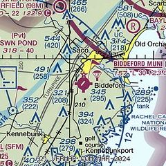
| Sectional chart |
|---|
|
| Airport distance calculator |
|---|
|
|
| Sunrise and sunset |
|---|
|
Times for 12-May-2025
| | Local
(UTC-4) | | Zulu
(UTC) |
|---|
| Morning civil twilight | | 04:49 | | 08:49 |
| Sunrise | | 05:22 | | 09:22 |
| Sunset | | 19:55 | | 23:55 |
| Evening civil twilight | | 20:28 | | 00:28 |
|
| Current date and time |
|---|
| Zulu (UTC) | 12-May-2025 22:44:16 |
|---|
| Local (UTC-4) | 12-May-2025 18:44:16 |
|---|
|
| METAR |
|---|
KSFM
12nm SW | 122156Z AUTO 26007KT 10SM BKN100 26/02 A3002 RMK AO2 SLP169 T02610022
|
KPWM
13nm NE | 122151Z 10005KT 10SM BKN090 16/07 A3003 RMK AO2 SLP170 T01560072 $
|
KDAW
22nm SW | 122151Z AUTO 10SM CLR 27/04 A3001 RMK AO2 SLP161 T02670039
|
|
| TAF |
|---|
KPWM
13nm NE | 121720Z 1218/1318 19015G25KT P6SM FEW250 FM122300 VRB05KT P6SM SCT110
|
|
| NOTAMs |
|---|
NOTAMs are issued by the DoD/FAA and will open in a separate window not controlled by AirNav.
|
|


