FAA INFORMATION EFFECTIVE 14 MAY 2026
Location
| FAA Identifier: | PWM |
| Lat/Long: | 43-38-44.3166N 070-18-31.0189W
43-38.738610N 070-18.516982W
43.6456435,-70.3086164
(estimated) |
| Elevation: | 75.7 ft. / 23.1 m (surveyed) |
| Variation: | 15W (2020) |
| From city: | 2 miles W of PORTLAND, ME |
| Time zone: | UTC -4 (UTC -5 during Standard Time) |
| Zip code: | 04102 |
Airport Operations
| Airport use: | Open to the public |
| Activation date: | 04/1940 |
| Control tower: | yes |
| ARTCC: | BOSTON CENTER |
| FSS: | BANGOR FLIGHT SERVICE STATION |
| NOTAMs facility: | PWM (NOTAM-D service available) |
| Attendance: | 0600-2200 |
| Wind indicator: | lighted |
| Segmented circle: | no |
| Lights: | WHEN TWR CLSD ACTVT MALSR RWY 29; REIL RWY 18 & 36; TDZL RWY 11; CNTLN RWY 11/29; PAPI RWY 11, 29, 18 & 36; HIRL RWY 11/29; MIRL RWY 18/36 - CTAF. |
| Beacon: | white-green (lighted land airport)
Operates sunset to sunrise. |
| Fire and rescue: | ARFF index C |
| International operations: | customs landing rights airport
GA CUST/IMG FAC LCTD AT CARGO APRON. ACFT ARRG/DEPG
CUST MUST USE EXTREME CTN WHEN NAVIGATING ON THE CARGO
APRON TO MINIMIZE JET BLAST EXPOSURE TO HNGRS &
ACFT. |
Airport Communications
| CTAF: | 120.9 |
| UNICOM: | 122.95 |
| ATIS: | 119.05 |
| WX ASOS: | 119.05 (207-419-5584) |
| PORTLAND GROUND: | 121.9 [0545-0000] |
| PORTLAND TOWER: | 120.9 257.8 [0545-0000] |
| PORTLAND APPROACH: | 119.75 269.35 [0545-0000] |
| BOSTON ARTCC APPROACH: | 132.4 [0000-0545] |
| PORTLAND DEPARTURE: | 119.75 269.35 [0545-0000] |
| BOSTON ARTCC DEPARTURE: | 132.4 [0000-0545] |
| CLEARANCE DELIVERY: | 121.9 |
| CLASS C: | 119.75 125.5 269.35 353.9 |
| EMERG: | 121.5 243.0 |
| VFR ADZY: | 120.9 |
- ATCT OCCASIONALLY STAYS OPEN BYD 0000 LCL DURG ADVERSE WEATHER.
- APCH/DEP SVC PRVDD BY BOSTON ARTCC ON FREQS 128.2/263.05 (WATERBORO RCAG) WHEN PORTLAND APCH CTL CLSD.
Nearby radio navigation aids
| VOR radial/distance | | VOR name | | Freq | | Var |
|---|
| ENEr062/18.7 | | KENNEBUNK VOR/DME | | 117.10 | | 17W |
| NDB name | | Hdg/Dist | | Freq | | Var | | ID |
|---|
| ROLLINS | | 058/34.1 | | 260 | | 16W | | ESG | . ... --. |
Airport Services
| Fuel available: | 100LL JET-A
100LL:FOR FUEL AFT HRS CALL 207-774-6318 OR 207-523-0988. |
| Parking: | hangars and tiedowns |
| Airframe service: | MAJOR |
| Powerplant service: | MAJOR |
| Bottled oxygen: | HIGH |
| Bulk oxygen: | HIGH |
Runway Information
Runway 11/29
| Dimensions: | 7200 x 150 ft. / 2195 x 46 m |
| Surface: | asphalt/grooved, in excellent condition |
| Weight bearing capacity: | | Single wheel: | 75.0 | | Double wheel: | 169.0 | | Double tandem: | 300.0 |
|
| Runway edge lights: | high intensity |
| RUNWAY 11 | | RUNWAY 29 |
| Latitude: | 43-38.751720N | | 43-38.642015N |
| Longitude: | 070-19.564418W | | 070-17.939490W |
| Elevation: | 75.7 ft. | | 42.2 ft. |
| Traffic pattern: | left | | left |
| Runway heading: | 110 magnetic, 095 true | | 290 magnetic, 275 true |
| Declared distances: | TORA:7200 TODA:7200 ASDA:7200 LDA:7200 | | TORA:7200 TODA:7200 ASDA:7200 LDA:7200 |
| Markings: | precision, in good condition | | precision, in good condition |
| Visual slope indicator: | 4-light PAPI on right (3.00 degrees glide path) | | 4-light PAPI on right (3.00 degrees glide path) |
| RVR equipment: | touchdown, midfield, rollout | | touchdown, midfield, rollout |
| Approach lights: | ALSF2: standard 2,400 foot high intensity approach lighting system with centerline sequenced flashers (category II or III)
ALSF-II BECOMES SSALS WHEN ATCT CLSD. | | MALSR: 1,400 foot medium intensity approach lighting system with runway alignment indicator lights |
| Runway end identifier lights: | no | | no |
| Centerline lights: | yes | | yes |
| Touchdown point: | yes, lighted | | yes, no lights |
| Instrument approach: | ILS/DME | | ILS/DME |
| Obstructions: | 42 ft. trees, 2000 ft. from runway, 675 ft. right of centerline, 43:1 slope to clear | | 166 ft. tree, 6400 ft. from runway, 1100 ft. right of centerline, 37:1 slope to clear |
Runway 18/36
| Dimensions: | 6100 x 150 ft. / 1859 x 46 m |
| Surface: | asphalt/grooved, in excellent condition |
| Weight bearing capacity: | | Single wheel: | 75.0 | | Double wheel: | 165.0 | | Double tandem: | 300.0 |
|
| Runway edge lights: | medium intensity |
| RUNWAY 18 | | RUNWAY 36 |
| Latitude: | 43-39.268393N | | 43-38.307060N |
| Longitude: | 070-18.439162W | | 070-18.039867W |
| Elevation: | 44.8 ft. | | 44.3 ft. |
| Traffic pattern: | left | | left |
| Runway heading: | 178 magnetic, 163 true | | 358 magnetic, 343 true |
| Displaced threshold: | 450 ft. | | 500 ft. |
| Declared distances: | TORA:6100 TODA:6100 ASDA:5600 LDA:5150 | | TORA:6100 TODA:6100 ASDA:5650 LDA:5150 |
| Markings: | nonprecision, in good condition | | nonprecision, in good condition |
| Visual slope indicator: | 4-light PAPI on left (3.00 degrees glide path) | | 4-light PAPI on left (3.25 degrees glide path) |
| Runway end identifier lights: | yes | | yes |
| Touchdown point: | yes, no lights | | yes, no lights |
| Obstructions: | 20 ft. tree, 600 ft. from runway, 60 ft. right of centerline, 20:1 slope to clear | | 60 ft. tree, 1300 ft. from runway, 300 ft. left of centerline, 18:1 slope to clear |
Airport Ownership and Management from official FAA records
| Ownership: | Publicly-owned |
| Owner: | CITY OF PORTLAND
CITY HALL, 389 CONGRESS ST
PORTLAND, ME 04101
Phone 207-874-8300 |
| Manager: | PAUL BRADBURY
1001 WESTBROOK ST
PORTLAND, ME 04102
Phone 207-756-8310 |
Additional Remarks
| A39-18/36 | PCR VALUE: 1439/F/C/X/T |
| A39-11/29 | PCR VALUE: 1468/F/C/X/T |
| - | NO TGLS DURG SNOW REMOVAL. |
| - | BIRDS OCNLY ON & INVOF ARPT. |
| - | PUSHBACK ONTO TWY A RQRD FM TRML GATES 1-8, TWY C RQRD FM TRML GATE 1A. ACFT MAY NOT PUSH SHORT OF TWY A FM GATES 1-8 NOR SHORT OF TWY C FM GATE 1A. CTC GND 121.9. ADZ PUSHBACK OPR YOU HAVE ALPHA OR CHARLIE PRIOR TO PUSH. |
| - | FOR CD WHEN ATCT CLSD, CTC BOSTON ARTCC AT 603-879-6859. |
| - | NOISE ABATEMENT PROCS IN AFCT FOR LDG RWY 11 & DEP RWY 29. |
| - | PAEW ADJ TO RWYS NGTS; GND VEHICLES MONITOR 120.9 WHEN ATCT CLSD. |
| - | PRIOR TO ANY RUN-UP CTC ARPT OPS ON FREQ 129.95 OR CALL 207-756-8310. |
| - | ACFT EMERGS BTN 0000-0545 CALL PORTLAND AIR RESCUE 207-874-8576. |
Instrument Procedures
NOTE: All procedures below are presented as PDF files. If you need a reader for these files, you should download the free Adobe Reader.NOT FOR NAVIGATION. Please procure official charts for flight.
FAA instrument procedures published for use from 14 May 2026 at 0901Z to 11 June 2026 at 0900Z.
STARs - Standard Terminal Arrivals |
|---|
| CDOGG FOUR (RNAV) | |
download (174KB) |
| SCOGS THREE (RNAV) | |
download (225KB) |
IAPs - Instrument Approach Procedures |
|---|
| ILS OR LOC RWY 11 | |
download (312KB) |
| ILS OR LOC RWY 29 | |
download (262KB) |
| ILS RWY 11 (SA CAT I) | |
download (264KB) |
| ILS RWY 29 (SA CAT I - II) | |
download (265KB) |
| ILS RWY 11 (CAT II - III) | |
download (255KB) |
| RNAV (RNP) Z RWY 29 **NEW** | |
download (278KB) |
| RNAV (GPS) RWY 11 | |
download (246KB) |
| RNAV (GPS) RWY 18 | |
download (248KB) |
| RNAV (GPS) RWY 29 | |
download (285KB) |
| RNAV (GPS) RWY 36 | |
download (256KB) |
| HARBOR VISUAL RWY 29 | |
download (244KB) |
| NOTE: Special Alternate Minimums apply | |
download (47KB) |
Departure Procedures |
|---|
| HSKEL THREE (RNAV) | |
download (236KB) |
| NUBLE FOUR (RNAV) | |
download (257KB) |
| PORTLAND SIX | |
download (175KB) |
| NOTE: Special Take-Off Minimums/Departure Procedures apply | |
download (256KB) |
Other nearby airports with instrument procedures:
B19 - Biddeford Municipal Airport (13 nm SW)
KBXM - Brunswick Executive Airport (22 nm NE)
KSFM - Sanford Seacoast Regional Airport (23 nm SW)
KLEW - Auburn/Lewiston Municipal Airport (24 nm N)
81B - Oxford County Regional Airport (32 nm N)
|
|

Road maps at:
MapQuest
Bing
Google
| Aerial photo |
|---|
WARNING: Photo may not be current or correct
 Photo by John Lars Allison SEL
Photo taken 16-May-2017
looking west.
Photo by John Lars Allison SEL
Photo taken 16-May-2017
looking west.
Do you have a better or more recent aerial photo of Portland International Jetport that you would like to share? If so, please send us your photo.
|
| Sectional chart |
|---|
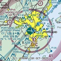
|
CAUTION: Diagram may not be current
 Download PDF
of official airport diagram from the FAA
| Airport distance calculator |
|---|
|
|
| Sunrise and sunset |
|---|
|
Times for 20-May-2026
| | Local
(UTC-4) | | Zulu
(UTC) |
|---|
| Morning civil twilight | | 04:38 | | 08:38 |
| Sunrise | | 05:12 | | 09:12 |
| Sunset | | 20:03 | | 00:03 |
| Evening civil twilight | | 20:37 | | 00:37 |
|
| Current date and time |
|---|
| Zulu (UTC) | 20-May-2026 11:42:47 |
|---|
| Local (UTC-4) | 20-May-2026 07:42:47 |
|---|
|
| METAR |
|---|
| KPWM | 201051Z 22003KT 10SM FEW100 FEW250 21/18 A2980 RMK AO2 SLP092 T02110183 $
|
|
| TAF |
|---|
| KPWM | 200903Z 2009/2106 23005KT P6SM SKC WS020/26030KT FM201300 26010G21KT P6SM FEW250 FM201700 28017G26KT P6SM SCT150 FM210000 31009KT P6SM SCT200
|
|
| NOTAMs |
|---|
NOTAMs are issued by the DoD/FAA and will open in a separate window not controlled by AirNav.
|
|


