FAA INFORMATION EFFECTIVE 30 OCTOBER 2025
Location
| FAA Identifier: | CLW |
| Lat/Long: | 27-58-37.9700N 082-45-32.6050W
27-58.632833N 082-45.543417W
27.9772139,-82.7590569
(estimated) |
| Elevation: | 71 ft. / 21.6 m (surveyed) |
| Variation: | 04W (2000) |
| From city: | 3 miles NE of CLEARWATER, FL |
| Time zone: | UTC -5 (UTC -4 during Daylight Saving Time) |
| Zip code: | 33755 |
Airport Operations
| Airport use: | Open to the public |
| Activation date: | 10/1942 |
| Control tower: | no |
| ARTCC: | MIAMI CENTER |
| FSS: | SAINT PETERSBURG FLIGHT SERVICE STATION |
| NOTAMs facility: | CLW (NOTAM-D service available) |
| Attendance: | 0700-1900
LNDGS & TKOFS PERMITTED 0700-2300. |
| Wind indicator: | lighted |
| Segmented circle: | yes
SEG CIRCLE PAINTED ON RWY. |
| Lights: | ACTVT VASI RWY 16 & 34; MIRL RWY 16/34 - CTAF. |
Airport Communications
| CTAF/UNICOM: | 123.0 |
| WX AWOS-3P: | 119.225 (727-462-6383) |
| TAMPA APPROACH: | 125.3 |
| TAMPA DEPARTURE: | 125.3 |
| WX ASOS at PIE (6 nm SE): | 134.5 (727-502-6385) |
| WX ASOS at TPA (12 nm E): | 126.45 (813-296-2752) |
| WX ASOS at SPG (15 nm SE): | 118.875 (727-821-4334) |
| WX AWOS-3 at TPF (17 nm E): | 118.925 (813-251-6824) |
Nearby radio navigation aids
| VOR radial/distance | | VOR name | | Freq | | Var |
|---|
| PIEr321/5.7 | | ST PETERSBURG VORTAC | | 116.40 | | 05W |
| SRQr348/35.8 | | SARASOTA VOR/DME | | 117.00 | | 05W |
| LALr268/39.5 | | LAKELAND VORTAC | | 116.00 | | 01E |
| NDB name | | Hdg/Dist | | Freq | | Var | | ID |
|---|
| CAPOK | | 255/3.1 | | 360 | | 05W | | PI | .--. .. |
Airport Services
| Fuel available: | 100LL JET-A |
| Parking: | tiedowns |
| Airframe service: | MAJOR |
| Powerplant service: | MAJOR |
| Bottled oxygen: | NONE |
| Bulk oxygen: | NONE |
Runway Information
Runway 16/34
| Dimensions: | 4108 x 75 ft. / 1252 x 23 m |
| Surface: | asphalt, in fair condition |
| Weight bearing capacity: | | PCN 8 /F/B/X/T | | Single wheel: | 27.0 | | Double wheel: | 42.0 |
|
| Runway edge lights: | medium intensity |
| RUNWAY 16 | | RUNWAY 34 |
| Latitude: | 27-58.938000N | | 27-58.327667N |
| Longitude: | 082-45.709667W | | 082-45.377167W |
| Elevation: | 65.9 ft. | | 69.3 ft. |
| Traffic pattern: | left | | right |
| Displaced threshold: | 357 ft. | | 846 ft. |
| Markings: | basic, in fair condition | | basic, in fair condition |
| Visual slope indicator: | 4-box VASI on left (3.50 degrees glide path) | | 4-box VASI on right (3.50 degrees glide path) |
| Touchdown point: | yes, no lights | | yes, no lights |
| Obstructions: | 28 ft. pole, 250 ft. from runway, 110 ft. right of centerline, 1:1 slope to clear
RWY 16 APCH RATIO 22:1 TO DTHR. | | 37 ft. trees, 350 ft. from runway, 115 ft. left of centerline, 4:1 slope to clear
RWY 34 APCH RATIO 20:1 TO DTHR. |
Airport Ownership and Management from official FAA records
| Ownership: | Publicly-owned |
| Owner: | CITY OF CLEARWATER
P.O. BOX 4748, ATTN: MARINE DEPT
CLEARWATER, FL 33758-4748
Phone 727-224-7005
CTC PERSON: MICHAEL MACDONALD 727-224-7005. |
| Manager: | WILLIAM HODGSON
25 CAUSEWAY BLVD., P.O. BOX 4748, P.O. BOX4748
CLEARWATER, FL 33767
Phone 727-224-7101
727-562-4955 EXT 3499 |
Additional Remarks
| - | FULL STOP LNDG ONLY. NO TOUCH & GO. |
| - | RY 16/34 TREES PENETRATE 7:1 TRANS SFC W SIDE. |
| - | NOISE ABATEMENT PROCS IN EFCT CTC FBO 727-325-5957. |
| - | FOR CD CTC TAMPA APCH AT 813-878-2528 |
Instrument Procedures
NOTE: All procedures below are presented as PDF files. If you need a reader for these files, you should download the free Adobe Reader.NOT FOR NAVIGATION. Please procure official charts for flight.
FAA instrument procedures published for use from 30 October 2025 at 0901Z to 27 November 2025 at 0900Z.
STARs - Standard Terminal Arrivals |
|---|
| BANGZ TWO (RNAV) | |
2 pages:
[1] [2] (422KB) |
| BLFRG THREE (RNAV) | |
2 pages:
[1] [2] (299KB) |
| DADES TWO (RNAV) | |
2 pages:
[1] [2] (427KB) |
| RAYZZ THREE (RNAV) | |
2 pages:
[1] [2] (438KB) |
Other nearby airports with instrument procedures:
KPIE - St Pete-Clearwater International Airport (6 nm SE)
KTPA - Tampa International Airport (12 nm E)
KSPG - Albert Whitted Airport (15 nm SE)
KMCF - MacDill Air Force Base (15 nm SE)
KTPF - Peter O Knight Airport (17 nm E)
|
|

Road maps at:
MapQuest
Bing
Google
| Aerial photo |
|---|
WARNING: Photo may not be current or correct
 Photo by David King
Taken in October 2013
looking northwest from 1,500 ft.
Photo by David King
Taken in October 2013
looking northwest from 1,500 ft.
Do you have a better or more recent aerial photo of Clearwater Air Park that you would like to share? If so, please send us your photo.
|
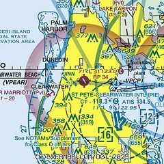
| Sectional chart |
|---|
|
| Airport distance calculator |
|---|
|
|
| Sunrise and sunset |
|---|
|
Times for 22-Nov-2025
| | Local
(UTC-5) | | Zulu
(UTC) |
|---|
| Morning civil twilight | | 06:34 | | 11:34 |
| Sunrise | | 06:59 | | 11:59 |
| Sunset | | 17:35 | | 22:35 |
| Evening civil twilight | | 18:00 | | 23:00 |
|
| Current date and time |
|---|
| Zulu (UTC) | 22-Nov-2025 20:58:19 |
|---|
| Local (UTC-5) | 22-Nov-2025 15:58:19 |
|---|
|
| METAR |
|---|
| KCLW | 222055Z AUTO 27006KT 10SM CLR 25/16 A3007 RMK AO2
|
KPIE
5nm SE | 222053Z 30005KT 10SM CLR 27/17 A3006 RMK AO2 SLP180 T02720172 56011
|
KTPA
12nm E | 222053Z 26006KT 10SM FEW040 FEW250 27/18 A3006 RMK AO2 SLP179 T02720183 56013
|
KSPG
14nm SE | 221753Z 24008KT 10SM CLR 27/18 A3008 RMK AO2 SLP185 T02670183 10278 20200 58017
|
KMCF
15nm SE | 221955Z AUTO 21006KT 10SM CLR 27/17 A3006 RMK AO2 SLP182 T02730171
|
|
| TAF |
|---|
KPIE
5nm SE | 221720Z 2218/2318 25007KT P6SM SCT250 FM222100 32007KT P6SM SCT250 FM230200 VRB03KT P6SM FEW250 FM231500 29006KT P6SM SCT250
|
KTPA
12nm E | 221720Z 2218/2324 23007KT P6SM SCT250 FM222100 30007KT P6SM SCT250 FM230200 VRB03KT P6SM FEW250 FM231500 26006KT P6SM SCT250
|
KMCF
15nm SE | 221700Z 2217/2323 23008KT 9999 SKC QNH3005INS BECMG 2309/2310 VRB06KT 6000 BR SKC QNH3006INS BECMG 2312/2313 27009KT 9999 NSW SCT040 QNH3004INS TX28/2218Z TN15/2309Z
|
|
| NOTAMs |
|---|
NOTAMs are issued by the DoD/FAA and will open in a separate window not controlled by AirNav.
|
|


