FAA INFORMATION EFFECTIVE 14 MAY 2026
Location
| FAA Identifier: | PIE |
| Lat/Long: | 27-54-31.0810N 082-41-11.4360W
27-54.518017N 082-41.190600W
27.9086336,-82.6865100
(estimated) |
| Elevation: | 10.7 ft. / 3.3 m (surveyed) |
| Variation: | 05W (2010) |
| From city: | 8 miles N of ST PETERSBURG-CLEARWATER, FL |
| Time zone: | UTC -4 (UTC -5 during Standard Time) |
| Zip code: | 33762 |
Airport Operations
| Airport use: | Open to the public |
| Activation date: | 10/1942 |
| Control tower: | yes |
| ARTCC: | MIAMI CENTER |
| FSS: | SAINT PETERSBURG FLIGHT SERVICE STATION |
| NOTAMs facility: | PIE (NOTAM-D service available) |
| Attendance: | CONTINUOUS |
| Wind indicator: | lighted |
| Segmented circle: | no |
| Lights: | WHEN ATCT CLSD ACTVT MALSR RWY 18; TDZ RWY 18; CNTLN RWY 18/36; MIRL RWY 04/22; HIRL RWY 18/36; TWY LGTS - CTAF. |
| Beacon: | white-green (lighted land airport)
Operates sunset to sunrise. |
| Fire and rescue: | ARFF index C |
| International operations: | customs landing rights airport |
Airport Communications
| CTAF: | 118.3 |
| UNICOM: | 122.95 |
| ATIS: | 134.5 |
| WX ASOS: | 134.5 (727-502-6385) |
| ST. PETERSBURG-CLEARWATER GROUND: | 121.9 348.6 [0600-2300] |
| ST. PETERSBURG-CLEARWATER TOWER: | 118.3 257.8 128.4 [0600-2300] |
| TAMPA APPROACH: | 125.3 |
| TAMPA DEPARTURE: | 125.3 |
| CLEARANCE DELIVERY: | 120.6 350.2 |
| BANGZ STAR: | 118.8 |
| BAYPO DP: | 125.3 |
| BLFRG STAR: | 119.65 |
| DADES STAR: | 135.5 |
| ENDED DP: | 125.3 |
| LLRGO DP: | 125.3 |
| RAYZZ STAR: | 118.8 |
| WX AWOS-3P at CLW (6 nm NW): | 119.225 (727-462-6383) |
| WX ASOS at TPA (9 nm NE): | 126.45 (813-296-2752) |
| WX ASOS at SPG (9 nm S): | 118.875 (727-821-4334) |
| WX AWOS-3 at TPF (13 nm E): | 118.925 (813-251-6824) |
| WX AWOS-3 at VDF (19 nm E): | 121.125 (813-630-0924) |
- SAID IN USE. OPERATE TRANSPONDERS WITH ALTITUDE REPORTING MODE AND ADS-B (IF EQUIPPED) ENABLED ON ALL AIRPORT SURFACES.
Nearby radio navigation aids
| VOR radial/distance | | VOR name | | Freq | | Var |
|---|
| PIE at field | | ST PETERSBURG VORTAC | | 116.40 | | 05W |
| SRQr353/30.8 | | SARASOTA VOR/DME | | 117.00 | | 05W |
| LALr262/36.0 | | LAKELAND VORTAC | | 116.00 | | 01E |
| NDB name | | Hdg/Dist | | Freq | | Var | | ID |
|---|
| CAPOK | | 175/5.3 | | 360 | | 05W | | PI | .--. .. |
Airport Services
| Fuel available: | 100 JET-A JET-A1+ |
| Parking: | hangars and tiedowns |
| Airframe service: | MAJOR |
| Powerplant service: | MAJOR |
| Bottled oxygen: | NONE |
| Bulk oxygen: | HIGH/LOW |
Runway Information
Runway 18/36
| Dimensions: | 9730 x 150 ft. / 2966 x 46 m |
| Surface: | asphalt/grooved, in excellent condition |
| Weight bearing capacity: | | Single wheel: | 120.0 | | Double wheel: | 218.0 | | Double tandem: | 413.0 | | Dual double tandem: | 866.0 |
|
| Runway edge lights: | high intensity |
| RUNWAY 18 | | RUNWAY 36 |
| Latitude: | 27-55.404895N | | 27-53.817560N |
| Longitude: | 082-41.442302W | | 082-41.169197W |
| Elevation: | 6.6 ft. | | 9.8 ft. |
| Traffic pattern: | left | | left |
| Runway heading: | 176 magnetic, 171 true | | 356 magnetic, 351 true |
| Displaced threshold: | no | | 930 ft. |
| Declared distances: | TORA:9730 TODA:9730 ASDA:9180 LDA:9180 | | TORA:9730 TODA:9730 ASDA:9650 LDA:8720 |
| Markings: | precision, in fair condition | | precision, in fair condition |
| Visual slope indicator: | 4-light PAPI on left (3.00 degrees glide path) | | 4-light PAPI on left (3.00 degrees glide path) |
| RVR equipment: | touchdown, midfield, rollout | | touchdown, midfield, rollout |
| Approach lights: | MALSR: 1,400 foot medium intensity approach lighting system with runway alignment indicator lights | | |
| Runway end identifier lights: | no | | no |
| Centerline lights: | yes | | yes |
| Touchdown point: | yes, lighted | | yes, no lights |
| Instrument approach: | ILS/DME | | ILS/DME |
| Obstructions: | 9 ft. brush, 665 ft. from runway, 280 ft. right of centerline | | 30 ft. tree, 450 ft. from runway, 425 ft. left of centerline, 8:1 slope to clear
6 FT FENCE 200 FT BFR AER 483 FT R OF CNTRLN. |
Runway 4/22
| Dimensions: | 6000 x 150 ft. / 1829 x 46 m |
| Surface: | asphalt/grooved, in fair condition |
| Weight bearing capacity: | | Single wheel: | 91.0 | | Double wheel: | 153.0 | | Double tandem: | 252.0 |
|
| Runway edge lights: | medium intensity |
| RUNWAY 4 | | RUNWAY 22 |
| Latitude: | 27-53.986070N | | 27-54.747608N |
| Longitude: | 082-41.360047W | | 082-40.647690W |
| Elevation: | 10.7 ft. | | 5.1 ft. |
| Traffic pattern: | left | | left |
| Runway heading: | 045 magnetic, 040 true | | 225 magnetic, 220 true |
| Declared distances: | TORA:6000 TODA:6000 ASDA:6000 LDA:6000 | | TORA:6000 TODA:6000 ASDA:6000 LDA:6000 |
| Markings: | nonprecision, in good condition | | nonprecision, in good condition |
| Visual slope indicator: | 4-light PAPI on left (3.00 degrees glide path) | | 4-light PAPI on left (3.00 degrees glide path) |
| Runway end identifier lights: | yes | | yes |
| Touchdown point: | yes, no lights | | yes, no lights |
| Obstructions: | 32 ft. trees, 1135 ft. from runway, 10 ft. left of centerline, 29:1 slope to clear | | 8 ft. road, 270 ft. from runway, 250 ft. left of centerline, 8:1 slope to clear
APCH RATIO 34:1 TO THR. |
Airport Ownership and Management from official FAA records
| Ownership: | Publicly-owned |
| Owner: | COUNTY OF PINELLAS
ST. PETE-CLEARWATER INTERNATIONAL, 14700 TERMINAL BLVD. SUITE 221
CLEARWATER, FL 33762
Phone 727-453-7800 |
| Manager: | MARK SPRAGUE
ST PETE-CLEARWATER INTERNATIONAL
CLEARWATER, FL 33762
Phone 727-453-7800 |
Additional Remarks
| A39-18/36 | PCR VALUE: 490/F/A/X/T |
| A39-04/22 | PCR VALUE: 360/F/B/X/T |
| - | BANNER TOWING NA. |
| - | BIRDS ON & INVOF ARPT. |
| - | FOR CD IF UNA TO CTC ON FSS FREQ, CTC TAMPA APCH AT 813-878-2528. |
| - | PPR RQRD FOR ALL TRANS ACFT REQUESTING TO PRK ON CLEARWATER USAR MIL RAMP/APRON. MUST CTC CLEARWATER ARMY SUPPORT FAC OPS AT (910)-771-3046 OR ASF MACDILL AT (813)-828-3183/3180 UP TO 7 DAYS BFR ARR. MIN NOTICE IS 24 HOURS BFR ARR. 1000Z-0300Z M-TH OR FRI 1000Z-1830Z EXCLUDING HOLIDAYS & WEEKENDS. |
| - | NOISE SENSITIVE AREA 5 MI N EXTDG 1 MI E & W OF LOC SB TO SHORELINE. |
| - | MILITARY: CONTRACT AVOIL O-128 AVBL. |
| - | TBJT LNDG RWY 18 & DEP RWY 36 USE PUBLD NOISE ABATEMENT PROC. |
| - | LGTS ON HWY N OF ARPT MAY BE MISTAKEN FOR RWY LGTS. |
Instrument Procedures
NOTE: All procedures below are presented as PDF files. If you need a reader for these files, you should download the free Adobe Reader.NOT FOR NAVIGATION. Please procure official charts for flight.
FAA instrument procedures published for use from 14 May 2026 at 0901Z to 11 June 2026 at 0900Z.
STARs - Standard Terminal Arrivals |
|---|
| BANGZ TWO (RNAV) | |
2 pages:
[1] [2] (424KB) |
| BLFRG THREE (RNAV) | |
2 pages:
[1] [2] (302KB) |
| DADES TWO (RNAV) | |
2 pages:
[1] [2] (429KB) |
| RAYZZ THREE (RNAV) | |
2 pages:
[1] [2] (443KB) |
IAPs - Instrument Approach Procedures |
|---|
| ILS OR LOC RWY 18 | |
download (342KB) |
| ILS OR LOC RWY 36 | |
download (305KB) |
| ILS RWY 18 (SA CAT I - II) | |
download (276KB) |
| RNAV (GPS) RWY 18 | |
download (259KB) |
| RNAV (GPS) RWY 36 | |
download (263KB) |
| VOR RWY 04 | |
download (242KB) |
| VOR RWY 36 | |
download (217KB) |
| VOR-B | |
download (188KB) |
| NORTH BAY VISUAL RWY 18 | |
download (200KB) |
| NOTE: Special Alternate Minimums apply | |
download (147KB) |
Departure Procedures |
|---|
| BAYPO TWO (RNAV) | |
2 pages:
[1] [2] (337KB) |
| ENDED TWO (RNAV) | |
2 pages:
[1] [2] (287KB) |
| LLRGO ONE (RNAV) | |
2 pages:
[1] [2] (308KB) |
| ST PETE ONE | |
download (202KB) |
| NOTE: Special Take-Off Minimums/Departure Procedures apply | |
download (287KB) |
Other nearby airports with instrument procedures:
KCLW - Clearwater Executive Airport (6 nm NW)
KTPA - Tampa International Airport (9 nm NE)
KSPG - Albert Whitted Airport (9 nm S)
KMCF - MacDill Air Force Base (9 nm E)
KTPF - Peter O Knight Airport (13 nm E)
KVDF - Tampa Executive Airport (19 nm E)
|
|

Road maps at:
MapQuest
Bing
Google
| Aerial photo |
|---|
WARNING: Photo may not be current or correct
 Photo taken 28-Sep-2012
looking southwest.
Photo taken 28-Sep-2012
looking southwest.
Do you have a better or more recent aerial photo of St Pete-Clearwater International Airport that you would like to share? If so, please send us your photo.
|
| Sectional chart |
|---|
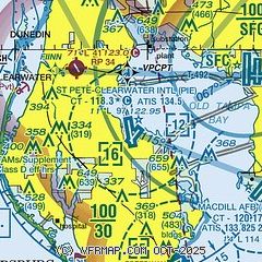
|
CAUTION: Diagram may not be current
 Download PDF
of official airport diagram from the FAA
| Airport distance calculator |
|---|
|
|
| Sunrise and sunset |
|---|
|
Times for 16-May-2026
| | Local
(UTC-4) | | Zulu
(UTC) |
|---|
| Morning civil twilight | | 06:16 | | 10:16 |
| Sunrise | | 06:42 | | 10:42 |
| Sunset | | 20:13 | | 00:13 |
| Evening civil twilight | | 20:38 | | 00:38 |
|
| Current date and time |
|---|
| Zulu (UTC) | 17-May-2026 03:14:49 |
|---|
| Local (UTC-4) | 16-May-2026 23:14:49 |
|---|
|
| METAR |
|---|
| KPIE | 170253Z 04006KT 10SM CLR 26/21 A3008 RMK AO2 SLP186 T02610206 53019 $
|
KCLW
6nm NW | 170255Z AUTO 00000KT CLR 25/19 A3009 RMK AO2
|
KTPA
9nm NE | 170253Z 03005KT 10SM FEW060 FEW120 BKN250 26/20 A3009 RMK AO2 SLP189 OCNL LTGIC DSNT NE AND SE CB DSNT NE AND SE T02610200 53022 $
|
KSPG
9nm S | 170253Z AUTO 03006KT 10SM CLR 28/21 A3006 RMK AO2 SLP180 T02780211 53020
|
KMCF
10nm E | 170155Z 34004KT 10SM FEW080 26/19 A3006 RMK AO2A LTG DSNT NE SLP182 T02640190
|
KTPF
13nm E | 170255Z AUTO 02004KT 10SM SCT260 26/19 A3008 RMK AO2 T02620192 53021 $
|
KVDF
19nm E | 170255Z AUTO 04003KT 10SM BKN260 24/20 A3008 RMK AO2 T02440205 52024
|
|
| TAF |
|---|
| KPIE | 161902Z 1619/1718 22012G18KT P6SM FEW250 FM162100 24012G18KT P6SM FEW040 FEW250 FM170000 26006KT P6SM SCT090 FM170300 VRB03KT P6SM SCT070 FM170600 11005KT P6SM SCT040 SCT250
|
KTPA
9nm NE | 162101Z 1621/1724 23011KT P6SM FEW060 FEW250 FM170300 VRB03KT P6SM SCT250 FM171600 12007KT P6SM VCSH SCT040 SCT250 FM172000 22010KT P6SM SCT050 SCT250 PROB30 1722/1724 4SM TSRA BKN030CB
|
KMCF
10nm E | 170055Z 1701/1807 28006KT 9999 FEW260 QNH3001INS BECMG 1717/1718 14003KT 8000 -SHRA SCT040 OVC060 QNH3009INS TEMPO 1719/1722 VRB12G18KT 5000 TSRA BKN040CB BECMG 1803/1804 11006KT 9999 NSW SCT035 BKN050 BKN075 OVC100 QNH3011INS TX32/1718Z TN24/1711Z
|
|
| NOTAMs |
|---|
NOTAMs are issued by the DoD/FAA and will open in a separate window not controlled by AirNav.
|
|


