FAA INFORMATION EFFECTIVE 02 OCTOBER 2025
Location
| FAA Identifier: | E68 |
| Lat/Long: | 33-05-07.1760N 112-09-39.5260W
33-05.119600N 112-09.658767W
33.0853267,-112.1609794
(estimated) |
| Elevation: | 1273 ft. / 388 m (estimated) |
| Variation: | 13E (1985) |
| From city: | 6 miles W of MARICOPA, AZ |
| Time zone: | UTC -7 (year round; does not observe DST) |
| Zip code: | 85239 |
Gliderport Operations
| Gliderport use: | Open to the public |
| Activation date: | 03/1969 |
| Control tower: | no |
| ARTCC: | ALBUQUERQUE CENTER |
| FSS: | PRESCOTT FLIGHT SERVICE STATION |
| NOTAMs facility: | PRC (NOTAM-D service available) |
| Attendance: | 0900-1700 |
| Wind indicator: | yes |
| Segmented circle: | yes |
Gliderport Communications
| CTAF: | 122.9 |
| WX AWOS-3 at A39 (13 nm SE): | 126.900 (520-568-7704) |
Nearby radio navigation aids
| VOR radial/distance | | VOR name | | Freq | | Var |
|---|
| TFDr301/17.4 | | STANFIELD VORTAC | | 114.80 | | 12E |
| PXRr193/23.0 | | PHOENIX VORTAC | | 115.60 | | 12E |
| GBNr059/27.0 | | GILA BEND VORTAC | | 116.60 | | 14E |
| IWAr230/28.7 | | WILLIE VORTAC | | 113.30 | | 13E |
| BXKr110/40.0 | | BUCKEYE VORTAC | | 110.60 | | 14E |
Gliderport Services
| Oil available: | 123.3 AVBL FOR COMM BTN GLIDER & TOW ACFT. |
| Parking: | tiedowns |
Runway Information
Runway 6R/24L
| Dimensions: | 2520 x 30 ft. / 768 x 9 m |
| Surface: | asphalt, in fair condition |
| RUNWAY 6R | | RUNWAY 24L |
| Latitude: | 33-05.049333N | | 33-05.163833N |
| Longitude: | 112-09.927667W | | 112-09.453000W |
| Traffic pattern: | right | | left |
| Runway end identifier lights: | no | | no |
Runway 7/25
| Dimensions: | 3740 x 20 ft. / 1140 x 6 m |
| Surface: | dirt, in fair condition |
| RUNWAY 7 | | RUNWAY 25 |
| Traffic pattern: | left | | left |
| Obstructions: | 10 ft. brush, 256 ft. from runway, 70 ft. right of centerline, 25:1 slope to clear | | 6 ft. brush, 105 ft. from runway, 55 ft. left of centerline, 17:1 slope to clear |
Runway 6C/24C
| Dimensions: | 1995 x 25 ft. / 608 x 8 m |
| Surface: | dirt, in fair condition |
| RUNWAY 6C | | RUNWAY 24C |
| Traffic pattern: | right | | left |
| Markings: | none | | none |
| Runway end identifier lights: | no | | no |
| Obstructions: | 4 ft. brush, 20 ft. from runway, 60 ft. left of centerline, 5:1 slope to clear | | 8 ft. brush, 100 ft. from runway, 75 ft. right of centerline, 12:1 slope to clear |
Runway 6L/24R
| Dimensions: | 1910 x 25 ft. / 582 x 8 m |
| Surface: | dirt, in fair condition |
| RUNWAY 6L | | RUNWAY 24R |
| Traffic pattern: | right | | left |
| Markings: | none | | none |
| Runway end identifier lights: | no | | no |
| Obstructions: | 10 ft. tree, 90 ft. from runway, 30 ft. right of centerline, 9:1 slope to clear | | none |
Gliderport Ownership and Management from official FAA records
| Ownership: | Privately-owned |
| Owner: | ARIZONA SOARING INC
PO BOX 858
MARICOPA, AZ 85139
Phone 520-568-2318 |
| Manager: | JASON STEPHENS
PO BOX 858
MARICOPA, AZ 85239
Phone 520-568-2318 |
Additional Remarks
| A58-06R | 4 FT BRUSH 117 FT L AT RWY END. |
| A58-24L | 5 FT BRUSH 40 FT L & 0-20 FT RWY END. |
| A30A-07 | CLSD INDEFLY. |
| - | OBSTRNS MTNS SW, N & NW. 1 FT BERM & 1 FT DITCH 30 FT NORTH OF RWY 06L/24R. |
| - | ARPT CLSD AT NIGHT. |
| - | FOR CD CTC PHOENIX APCH AT 602-306-2565. |
| - | GLIDERS NOT EQUIPPED WITH ADS-B |
| - | PWR ACFT PAT S OF RWYS; GLIDER PAT N OF RWYS. |
| - | PWR OPS USE RWY NOT IN USE BY GLIDERS. |
| - | AEROBATIC BOX ACTV 0900-1800; ONE SQUARE MI ARND PXR194023. |
| - | HVY NO RADIO ACT. |
| - | TKOFF PAVED RWY ONLY. |
| - | ALERT: HVY GLIDER TFC OPS WO COM WI 5 NM. |
| - | ALL OPS PPR DUE TO GLIDER ACT - AMGR. |
Instrument Procedures
There are no published instrument procedures at E68.
Some nearby airports with instrument procedures:
P19 - Stellar Airpark (18 nm NE)
KCHD - Chandler Municipal Airport (21 nm NE)
KCGZ - Casa Grande Municipal Airport (21 nm E)
KPHX - Phoenix Sky Harbor International Airport (22 nm N)
KGYR - Phoenix Goodyear Airport (23 nm NW)
|
|

Road maps at:
MapQuest
Bing
Google
| Aerial photo |
|---|
WARNING: Photo may not be current or correct

Do you have a better or more recent aerial photo of Estrella Sailport that you would like to share? If so, please send us your photo.
|
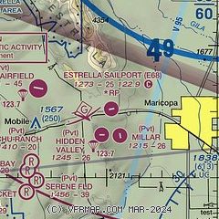
| Sectional chart |
|---|
|
| Airport distance calculator |
|---|
|
|
| Sunrise and sunset |
|---|
|
Times for 12-Oct-2025
| | Local
(UTC-7) | | Zulu
(UTC) |
|---|
| Morning civil twilight | | 06:07 | | 13:07 |
| Sunrise | | 06:32 | | 13:32 |
| Sunset | | 17:59 | | 00:59 |
| Evening civil twilight | | 18:23 | | 01:23 |
|
| Current date and time |
|---|
| Zulu (UTC) | 12-Oct-2025 20:13:03 |
|---|
| Local (UTC-7) | 12-Oct-2025 13:13:03 |
|---|
|
| METAR |
|---|
KA39
13nm SE | 121955Z AUTO 00000KT 10SM SCT120 24/19 A2977 RMK AO2
|
KCHD
20nm NE | 121947Z 05006KT 10SM BKN100 23/21 A2973
|
KCGZ
21nm E | 121956Z AUTO 04003KT 10SM CLR 23/20 A2974 RMK AO2 RAE25 SLP059 T02280200 PNO $
|
KPHX
22nm N | 121951Z 09005KT 10SM FEW020 SCT040 BKN095 24/20 A2971 RMK AO2 SLP047 T02390200 $
|
KGYR
22nm NW | 121947Z 14007KT 10SM OVC009 24/22 A2975
|
|
| TAF |
|---|
KPHX
22nm N | 121758Z 1218/1324 10008KT P6SM VCSH SCT020 BKN050 BKN070 TEMPO 1218/1220 BKN030 FM122000 15007KT P6SM FEW020 SCT050 BKN070 FM130300 12005KT P6SM SCT070 BKN100 FM130900 VRB05KT P6SM VCSH BKN050 BKN100 FM131400 13007KT P6SM FEW070 SCT100 FM132000 17010KT P6SM VCSH SCT050 BKN070 PROB30 1320/1323 TSRA BKN050CB
|
|
| NOTAMs |
|---|
NOTAMs are issued by the DoD/FAA and will open in a separate window not controlled by AirNav.
|
|

