FAA INFORMATION EFFECTIVE 16 APRIL 2026
Location
| FAA Identifier: | CHD |
| Lat/Long: | 33-16-08.7460N 111-48-40.0360W
33-16.145767N 111-48.667267W
33.2690961,-111.8111211
(estimated) |
| Elevation: | 1243.4 ft. / 379.0 m (surveyed) |
| Variation: | 12E (2000) |
| From city: | 3 miles SE of CHANDLER, AZ |
| Time zone: | UTC -7 (year round; does not observe DST) |
| Zip code: | 85249 |
Airport Operations
| Airport use: | Open to the public |
| Control tower: | yes |
| ARTCC: | ALBUQUERQUE CENTER |
| FSS: | PRESCOTT FLIGHT SERVICE STATION |
| NOTAMs facility: | CHD (NOTAM-D service available) |
| Attendance: | MON-FRI 0500-1700, ALL SAT-SUN 0500-1530 |
| Pattern altitude: | 2300.4 ft. MSL
FIXED WING - 2300 FT MSL. ROTORWING - 1900 FT MSL. |
| Wind indicator: | lighted |
| Segmented circle: | yes |
| Lights: | WHEN ATCT CLSD ACTVT PAPI RWY 04L, 04R, 22L & 22R; MIRL RWY 04R/22L & 04L/22R - CTAF. REIL RWY 4R & 22L ON CONSLY. |
| Beacon: | white-green (lighted land airport)
Operates sunset to sunrise. |
Airport Communications
| CTAF: | 126.1 |
| UNICOM: | 122.95 |
| ATIS: | 128.325 |
| WX AWOS-3PT: | PHONE 480-814-9952 |
| CHANDLER GROUND: | 124.4 [0600-2100] |
| CHANDLER TOWER: | 126.1 ;ARR N &W 126.1 ;DEP RWY 04L/22R 133.1 ;ARR S & E 133.1 ;DEP RWY 04R/22L [0600-2100] |
| PHOENIX APPROACH: | 123.7 |
| PHOENIX DEPARTURE: | 123.7 |
| ARLIN STAR: | 124.1 |
| BLYTHE STAR: | 124.1 |
| DSERT STAR: | 120.7 |
| HUUTY STAR: | 124.9 |
| SUNSS STAR: | 124.1 |
| WX AWOS-3 at IWA (8 nm E): | 133.5 (480-988-9428) |
| WX ASOS at FFZ (12 nm N): | PHONE 480-641-4111 |
| WX ASOS at PHX (14 nm NW): | PHONE 602-551-6092 |
| WX AWOS-3 at A39 (18 nm S): | 126.900 (520-568-7704) |
| WX AWOS-3PT at CGZ (19 nm S): | 132.175 (520-836-3392) |
Nearby radio navigation aids
| VOR radial/distance | | VOR name | | Freq | | Var |
|---|
| IWAr243/8.3 | | WILLIE VORTAC | | 113.30 | | 13E |
| PXRr129/12.7 | | PHOENIX VORTAC | | 115.60 | | 12E |
| TFDr000/23.5 | | STANFIELD VORTAC | | 114.80 | | 12E |
Airport Services
| Fuel available: | 100LL JET-A+ |
| Parking: | tiedowns |
| Airframe service: | MAJOR |
| Powerplant service: | MAJOR |
| Bottled oxygen: | HIGH/LOW |
| Bulk oxygen: | HIGH/LOW |
Runway Information
Runway 4R/22L
| Dimensions: | 4870 x 75 ft. / 1484 x 23 m |
| Surface: | asphalt, in good condition |
| Weight bearing capacity: | |
| Runway edge lights: | medium intensity |
| Operational restrictions: | RWY 4R CALM WIND RWY. |
| RUNWAY 4R | | RUNWAY 22L |
| Latitude: | 33-15.943492N | | 33-16.463547N |
| Longitude: | 111-48.849780W | | 111-48.121573W |
| Elevation: | 1235.9 ft. | | 1243.3 ft. |
| Traffic pattern: | right | | left |
| Runway heading: | 038 magnetic, 050 true | | 218 magnetic, 230 true |
| Markings: | nonprecision, in good condition | | nonprecision, in fair condition |
| Visual slope indicator: | 4-light PAPI on left (3.00 degrees glide path) | | 4-light PAPI on left (3.00 degrees glide path) |
| Runway end identifier lights: | yes | | yes |
| Touchdown point: | yes, no lights | | yes, no lights |
Runway 4L/22R
| Dimensions: | 4401 x 75 ft. / 1341 x 23 m |
| Surface: | asphalt, in good condition |
| Weight bearing capacity: | |
| Runway edge lights: | medium intensity |
| Operational restrictions: | RWY 4L CALM WIND RWY. |
| RUNWAY 4L | | RUNWAY 22R |
| Latitude: | 33-15.846785N | | 33-16.316902N |
| Longitude: | 111-49.197143W | | 111-48.539157W |
| Elevation: | 1231.0 ft. | | 1236.4 ft. |
| Traffic pattern: | left | | right |
| Runway heading: | 038 magnetic, 050 true | | 218 magnetic, 230 true |
| Markings: | basic, in fair condition | | basic, in fair condition |
| Visual slope indicator: | 4-light PAPI on left (3.50 degrees glide path) | | 4-light PAPI on left (3.00 degrees glide path) |
| Touchdown point: | yes, no lights | | yes, no lights |
Helipad H1
| Dimensions: | 100 x 100 ft. / 30 x 30 m |
| Surface: | concrete, in excellent condition |
| Latitude: | 33-16.409333N | | |
| Longitude: | 111-47.972500W | | |
| Elevation: | 1236.0 ft. | | |
| Traffic pattern: | left | | left |
| Markings: | basic, in good condition | | |
Airport Ownership and Management from official FAA records
| Ownership: | Publicly-owned |
| Owner: | CITY OF CHANDLER
175 S. ARIZONA AVE
CHANDLER, AZ 85225
Phone 480-782-2200 |
| Manager: | RYAN REEVES
CHANDLER MUNICIPAL AIRPORT, MS 802, PO BOX 4008
CHANDLER, AZ 85244
Phone 480-782-3540 |
Additional Remarks
| A30A-22L | SHORT APCH NA. |
| A30A-22R | 85 FT ANT 1/4 MI N OF THR. |
| - | 135 FT LGTD PWR POLES & LINES N-S 1.5 MI W. |
| - | 135 FT UNLGTD PWR POLES & LINES E-W 1 MI S. |
| - | TWY A BTN TWY D & F NOT VIS FM ATCT. |
| - | TSNT HELI PRKG & PAX PUP N SIDE BY TWY N. |
| - | HOPS ON TWY C; CHARLIE PAT FOR HEL TRNG. |
| - | WHEN ATCT CLSD, FOR CD CTC PHOENIX APCH - 602-306-2565. |
| - | GA TSNT FIXED WING PRKG BOXES IN FRONT OF TRML. |
| - | BIRDS & WILDLIFE ON & INVOF OF ARPT. |
| - | PARL RWYS; STAGGERED APCH ENDS. |
| - | AVOID OTFC OF HIGH SCHOOL; 2 NM SW. |
Instrument Procedures
NOTE: All procedures below are presented as PDF files. If you need a reader for these files, you should download the free Adobe Reader.NOT FOR NAVIGATION. Please procure official charts for flight.
FAA instrument procedures published for use from 16 April 2026 at 0901Z to 14 May 2026 at 0900Z.
STARs - Standard Terminal Arrivals |
|---|
| ARLIN FOUR | |
download (285KB) |
| BLYTHE FIVE | |
download (255KB) |
| DSERT TWO (RNAV) **CHANGED** | |
2 pages:
[1] [2] (312KB) |
| HUUTY ONE (RNAV) | |
download (234KB) |
| SUNSS EIGHT | |
download (237KB) |
IAPs - Instrument Approach Procedures |
|---|
| RNAV (GPS) RWY 04R | |
download (201KB) |
| VOR RWY 04R | |
download (192KB) |
Departure Procedures |
|---|
| BNYRD SIX (RNAV) | |
download (162KB) |
| FTHLS SIX (RNAV) | |
download (217KB) |
| IZZZO EIGHT (RNAV) **CHANGED** | |
download (206KB) |
| JUDTH SEVEN (RNAV) | |
download (159KB) |
| KATMN SIX (RNAV) | |
download (162KB) |
| LALUZ SIX (RNAV) | |
download (221KB) |
| MAYSA SEVEN (RNAV) | |
download (160KB) |
| SNOBL SIX (RNAV) | |
download (220KB) |
| YOTES SIX (RNAV) | |
download (187KB) |
| NOTE: Special Take-Off Minimums/Departure Procedures apply | |
download |
Other nearby airports with instrument procedures:
P19 - Stellar Airpark (6 nm W)
KIWA - Mesa Gateway Airport (8 nm E)
KFFZ - Falcon Field Airport (12 nm N)
KPHX - Phoenix Sky Harbor International Airport (14 nm NW)
KCGZ - Casa Grande Municipal Airport (19 nm S)
|
|

Road maps at:
MapQuest
Bing
Google
| Aerial photo |
|---|
WARNING: Photo may not be current or correct
 Photo by Adar Lotan
Photo taken 07-Mar-2013
from 3,000 AGL looking north.
Photo by Adar Lotan
Photo taken 07-Mar-2013
from 3,000 AGL looking north.
Do you have a better or more recent aerial photo of Chandler Municipal Airport that you would like to share? If so, please send us your photo.
|
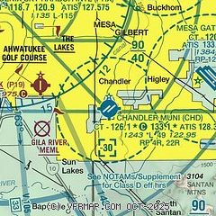
| Sectional chart |
|---|
|
CAUTION: Diagram may not be current
 Download PDF
of official airport diagram from the FAA
| Airport distance calculator |
|---|
|
|
| Sunrise and sunset |
|---|
|
Times for 06-May-2026
| | Local
(UTC-7) | | Zulu
(UTC) |
|---|
| Morning civil twilight | | 05:09 | | 12:09 |
| Sunrise | | 05:35 | | 12:35 |
| Sunset | | 19:12 | | 02:12 |
| Evening civil twilight | | 19:39 | | 02:39 |
|
| Current date and time |
|---|
| Zulu (UTC) | 06-May-2026 16:34:39 |
|---|
| Local (UTC-7) | 06-May-2026 09:34:39 |
|---|
|
| METAR |
|---|
| KCHD | 061547Z 18004KT 10SM CLR 21/04 A3001
|
KIWA
8nm E | 061549Z 00000KT 10SM CLR 20/03 A3002
|
KFFZ
13nm N | 061554Z 23003KT 10SM CLR 20/02 A3000 RMK AO2 SLP141 T02000022
|
KPHX
16nm NW | 061551Z VRB03KT 10SM FEW020 22/03 A2998 RMK AO2 SLP140 FU FEW020 DSNT W T02170033
|
KA39
18nm S | 061555Z AUTO 30003KT 10SM CLR 20/04 A3005 RMK AO2
|
|
| TAF |
|---|
KIWA
8nm E | 061120Z 0612/0712 12006KT P6SM SKC FM061700 28007KT P6SM SKC FM070600 10005KT P6SM SKC
|
KPHX
16nm NW | 061120Z 0612/0718 20004KT P6SM SKC FM061230 11005KT P6SM SKC FM061500 VRB05KT P6SM SKC FM061800 27006KT P6SM SKC FM070900 10006KT P6SM SKC
|
|
| NOTAMs |
|---|
NOTAMs are issued by the DoD/FAA and will open in a separate window not controlled by AirNav.
|
|


