FAA INFORMATION EFFECTIVE 04 SEPTEMBER 2025
Location
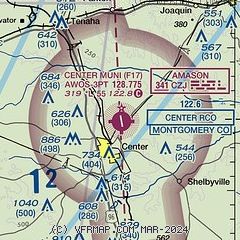
| FAA Identifier: | F17 |
| Lat/Long: | 31-49-53.7000N 094-09-23.1000W
31-49.895000N 094-09.385000W
31.8315833,-94.1564167
(estimated) |
| Elevation: | 318.6 ft. / 97.1 m (surveyed) |
| Variation: | 04E (1995) |
| From city: | 3 miles NE of CENTER, TX |
| Time zone: | UTC -5 (UTC -6 during Standard Time) |
| Zip code: | 75935 |
Airport Operations
| Airport use: | Open to the public |
| Activation date: | 02/1949 |
| Control tower: | no |
| ARTCC: | FORT WORTH CENTER |
| FSS: | MONTGOMERY COUNTY FLIGHT SERVICE STATION |
| NOTAMs facility: | F17 (NOTAM-D service available) |
| Attendance: | MON-FRI 0800-1500 |
| Wind indicator: | lighted |
| Segmented circle: | yes |
| Lights: | MIRL RWY 17/35 PRESET LOW INTST; TO INCR INTST ACTVT - CTAF. |
| Beacon: | white-green (lighted land airport)
Operates sunset to sunrise. |
Airport Communications
| CTAF/UNICOM: | 122.8 |
| WX AWOS-3PT: | 128.775 (936-598-3355) |
- APCH/DEP CTL SVC PRVDD BY FORT WORTH ARTCC (ZFW) ON FREQS 126.325/346.25 (SHREVEPORT RCAG).
Nearby radio navigation aids
| NDB name | | Hdg/Dist | | Freq | | Var | | ID |
|---|
| AMASON | | at field | | 341 | | 04E | | CZJ | -.-. --.. .--- |
Airport Services
| Fuel available: | 100LL JET-A+
100LL:SELF SVC FUEL. |
| Parking: | tiedowns |
| Airframe service: | MINOR |
| Powerplant service: | MAJOR |
| Bottled oxygen: | NONE |
| Bulk oxygen: | NONE |
Runway Information
Runway 17/35
| Dimensions: | 5501 x 75 ft. / 1677 x 23 m |
| Surface: | asphalt, in good condition |
| Weight bearing capacity: | |
| Runway edge lights: | medium intensity |
| RUNWAY 17 | | RUNWAY 35 |
| Latitude: | 31-50.343220N | | 31-49.448257N |
| Longitude: | 094-09.472858W | | 094-09.298037W |
| Elevation: | 318.5 ft. | | 290.9 ft. |
| Traffic pattern: | left | | left |
| Runway heading: | 167 magnetic, 171 true | | 347 magnetic, 351 true |
| Markings: | nonprecision, in good condition | | nonprecision, in good condition |
| Visual slope indicator: | 2-light PAPI on left (3.00 degrees glide path) | | 2-light PAPI on left (3.00 degrees glide path) |
| Touchdown point: | yes, no lights | | yes, no lights |
| Obstructions: | 18 ft. trees, 201 ft. from runway, 249 ft. right of centerline, 1:1 slope to clear
15 FT BRUSH, 0-200 FT DSTC, 214- 249 FT R. | | 46 ft. trees, 824 ft. from runway, 230 ft. right of centerline, 13:1 slope to clear |
Airport Ownership and Management from official FAA records
| Ownership: | Publicly-owned |
| Owner: | CITY OF CENTER
PO BOX 1744
CENTER, TX 75935
Phone 936-598-2941 |
| Manager: | CHAD NEHRING
PO BOX 1744
CENTER, TX 75935
Phone 936-598-8119
EMERGENCY PHONE: 936-598-2788, POLICE DISPATCH. |
Additional Remarks
| - | DEER ON & INVOF ARPT. |
| - | FOR CD IF UNA TO CTC ON FSS FREQ, CTC FORT WORTH ARTCC AT 817-858-7584. |
Instrument Procedures
NOTE: All procedures below are presented as PDF files. If you need a reader for these files, you should download the free Adobe Reader.NOT FOR NAVIGATION. Please procure official charts for flight.
FAA instrument procedures published for use from 04 September 2025 at 0901Z to 02 October 2025 at 0900z.
IAPs - Instrument Approach Procedures |
|---|
| RNAV (GPS) RWY 17 | |
download (171KB) |
| RNAV (GPS) RWY 35 | |
download (192KB) |
| NDB RWY 17 | |
download (188KB) |
| NOTE: Special Take-Off Minimums/Departure Procedures apply | |
download (70KB) |
Other nearby airports with instrument procedures:
4F2 - Panola County Airport-Sharpe Field (22 nm N)
3F3 - C E 'Rusty' Williams Airport (25 nm NE)
KOCH - Nacogdoches A L Mangham Jr. Regional Airport (32 nm SW)
3R4 - Hart Airport (38 nm SE)
KRFI - Rusk County Airport (40 nm NW)
|
|

Road maps at:
MapQuest
Bing
Google
| Aerial photo |
|---|

|
| Sectional chart |
|---|
|
| Airport distance calculator |
|---|
|
|
| Sunrise and sunset |
|---|
|
Times for 01-Oct-2025
| | Local
(UTC-5) | | Zulu
(UTC) |
|---|
| Morning civil twilight | | 06:47 | | 11:47 |
| Sunrise | | 07:11 | | 12:11 |
| Sunset | | 19:01 | | 00:01 |
| Evening civil twilight | | 19:25 | | 00:25 |
|
| Current date and time |
|---|
| Zulu (UTC) | 01-Oct-2025 09:00:35 |
|---|
| Local (UTC-5) | 01-Oct-2025 04:00:35 |
|---|
|
| METAR |
|---|
| KF17 | 010835Z AUTO 00000KT 10SM CLR 17/16 A3002 RMK AO2
|
|
| TAF |
|---|
KSHV
41nm NE | 010520Z 0106/0206 VRB03KT P6SM SCT100 FM011500 01004KT P6SM FEW250 FM011900 36005KT P6SM SCT050 FM020000 00000KT P6SM FEW250
|
KGGG
44nm NW | 010520Z 0106/0206 VRB03KT P6SM FEW100 FM011500 VRB04KT P6SM SCT250 FM011900 02005KT P6SM SCT050 FM020000 00000KT P6SM SKC
|
KLFK
47nm SW | 010520Z 0106/0206 VRB03KT P6SM FEW100 FM011200 00000KT 4SM BR SCT250 FM011300 VRB03KT P6SM SCT250 FM011900 36004KT P6SM SCT050 FM020000 00000KT P6SM SKC
|
KBAD
47nm NE | 010350Z 0104/0210 35005KT 9999 BKN180 QNH2999INS BECMG 0115/0116 01008KT 9999 SCT040 QNH2997INS BECMG 0201/0202 06005KT 9999 SKC QNH3004INS TX32/0120Z TN19/0112Z
|
|
| NOTAMs |
|---|
NOTAMs are issued by the DoD/FAA and will open in a separate window not controlled by AirNav.
|
|

