FAA INFORMATION EFFECTIVE 21 MARCH 2024
Location
| FAA Identifier: | FFA |
| Lat/Long: | 36-01-03.3000N 075-40-17.7000W
36-01.055000N 075-40.295000W
36.0175833,-75.6715833
(estimated) |
| Elevation: | 11.9 ft. / 3.6 m (surveyed) |
| Variation: | 11W (2020) |
| From city: | 1 mile W of KILL DEVIL HILLS, NC |
| Time zone: | UTC -4 (UTC -5 during Standard Time) |
| Zip code: | 27948 |
Airport Operations
| Airport use: | Open to the public |
| Control tower: | no |
| ARTCC: | WASHINGTON CENTER |
| FSS: | RALEIGH FLIGHT SERVICE STATION |
| NOTAMs facility: | FFA (NOTAM-D service available) |
| Attendance: | UNATNDD |
| Wind indicator: | lighted |
| Segmented circle: | yes |
Airport Communications
| CTAF: | 122.9 |
| WX AWOS-3: | 118.075 (252-449-0698) |
| CHERRY POINT APPROACH: | 124.725 |
| CHERRY POINT DEPARTURE: | 124.725 |
| WX AWOS-3 at MQI (6 nm S): | 128.275 (252-473-2826) |
Nearby radio navigation aids
| VOR radial/distance | | VOR name | | Freq | | Var |
|---|
| RBXr020/6.0 | | WRIGHT BROTHERS VOR/DME | | 111.60 | | 08W |
| ECGr128/28.4 | | ELIZABETH CITY VOR/DME | | 115.75 | | 07W |
| NDB name | | Hdg/Dist | | Freq | | Var | | ID |
|---|
| MANTEO | | 020/6.2 | | 370 | | 09W | | MQI | -- --.- .. |
| WOODVILLE | | 126/33.7 | | 254 | | 10W | | LLW | .-.. .-.. .-- |
Airport Services
| Parking: | tiedowns |
| Airframe service: | NONE |
| Powerplant service: | NONE |
| Bottled oxygen: | NONE |
| Bulk oxygen: | NONE |
Runway Information
Runway 3/21
| Dimensions: | 3000 x 60 ft. / 914 x 18 m |
| Surface: | asphalt, in good condition |
| Weight bearing capacity: | |
| RUNWAY 3 | | RUNWAY 21 |
| Latitude: | 36-00.816898N | | 36-01.294677N |
| Longitude: | 075-40.372653W | | 075-40.215673W |
| Elevation: | 11.6 ft. | | 8.0 ft. |
| Traffic pattern: | left | | right |
| Runway heading: | 026 magnetic, 015 true | | 206 magnetic, 195 true |
| Markings: | nonprecision, in good condition | | nonprecision, in good condition |
| Touchdown point: | yes, no lights | | yes, no lights |
| Obstructions: | 92 ft. trees, 348 ft. from runway, 176 ft. right of centerline, 1:1 slope to clear
10 FT ROAD 125 FT R; 0-200 FT FM THR. | | 37 ft. trees, 362 ft. from runway, 214 ft. right of centerline, 4:1 slope to clear
37 FT TREES 109 FT FM THR OFFSET 213 FT R. |
Airport Ownership and Management from official FAA records
| Ownership: | Publicly-owned |
| Owner: | NATIONAL PARK SVC.
1401 NATIONAL PARK DR.
MANTEO, NC 27954-2708
Phone 252-478-9000
ARPT LEASED TO NC DOT UNDER SPECIAL-USE PERMIT; CTC NR 919-814-0550. |
| Manager: | MARK SEAMAN
1401 NATIONAL PARK DR.
MANTEO, NC 27984-2708
Phone 252-475-9000
NTL PARKS SVC NR ANSWERED 7 DAYS A WEEK BTWN 0800 TO 1700. |
Airport Operational Statistics
| Aircraft operations: avg 103/day * | | 61% | local general aviation | | 37% | transient general aviation | | 1% | military | | * for 12-month period ending 20 August 2021 | |
Additional Remarks
| - | MAX OF 24 HRS PRKG PMTD. NO MORE THAN TWO OVNGT STAYS PER MONTH. |
| - | RWY 21 HAS 10 FT DEEP DITCH 400 FT FM THR. |
| - | DEER AND BIRDS ON & INVOF ARPT. |
| - | FOR CD CTC WASHINGTON ARTCC AT 703-771-3587. |
| - | SITE OF FIRST FLIGHT BY WRIGHT BROTHERS. |
| - | RESTROOM FAC ON SITE; KEY CODE ACES TO PILOT LOUNGE. |
| - | HANG GLIDING & POWERED HANG GLIDING TO 4000 FT INVOF ARPT FROM SR-SS YEAR ROUND. |
| - | ARPT CLSD 30 MIN AFT SS TIL 30 MIN BEFORE SR. |
| - | 100 FT+ UNMKD TRANSMISSION PLINES 1300 FT FM THR IN APCH AREA RWY 21; 300 FT TWR AND TANK 1/2 MI N OF RWY 21 THR. |
| - | HOLDLINES RWY 21 ARE 115 FT FM CNTRLN. |
Instrument Procedures
NOTE: All procedures below are presented as PDF files. If you need a reader for these files, you should download the free Adobe Reader.NOT FOR NAVIGATION. Please procure official charts for flight.
FAA instrument procedures published for use from 21 March 2024 at 0901Z to 18 April 2024 at 0900z.
IAPs - Instrument Approach Procedures |
|---|
| RNAV (GPS) RWY 03 | |
download (172KB) |
| RNAV (GPS) RWY 21 | |
download (184KB) |
| NOTE: Special Alternate Minimums apply | |
download |
| NOTE: Special Take-Off Minimums/Departure Procedures apply | |
download (258KB) |
Other nearby airports with instrument procedures:
KMQI - Dare County Regional Airport (6 nm S)
KONX - Currituck County Regional Airport (28 nm NW)
KECG - Elizabeth City Coast Guard Air Station/Regional Airport (28 nm NW)
7W6 - Hyde County Airport (31 nm SW)
KEDE - Northeastern Regional Airport (44 nm W)
|
|

Road maps at:
MapQuest
Bing
Google
| Aerial photo |
|---|
WARNING: Photo may not be current or correct
 Photo by Antonio Gemma More'
photo01aviation.com
Photo taken 11-Jul-2017
looking north.
Do you have a better or more recent aerial photo of First Flight Airport that you would like to share? If so, please send us your photo.
|
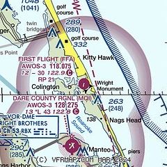
| Sectional chart |
|---|
|
| Airport distance calculator |
|---|
|
|
| Sunrise and sunset |
|---|
|
Times for 16-Apr-2024
| | Local
(UTC-4) | | Zulu
(UTC) |
|---|
| Morning civil twilight | | 06:01 | | 10:01 |
| Sunrise | | 06:28 | | 10:28 |
| Sunset | | 19:37 | | 23:37 |
| Evening civil twilight | | 20:03 | | 00:03 |
|
| Current date and time |
|---|
| Zulu (UTC) | 17-Apr-2024 02:48:24 |
|---|
| Local (UTC-4) | 16-Apr-2024 22:48:24 |
|---|
|
| METAR |
|---|
| KFFA | 170230Z AUTO 00000KT 10SM CLR 12/09 A3018 RMK AO2 T01220085
|
KMQI
6nm S | 170230Z AUTO 09006KT 10SM CLR 14/07 A3020 RMK AO2 T01430071
|
|
| TAF |
|---|
KECG
29nm NW | 161724Z 1618/1718 05015G23KT P6SM SCT250 FM162000 08010KT P6SM FEW250 FM170300 VRB05KT P6SM SCT200 FM171200 16007KT P6SM BKN025
|
|
| NOTAMs |
|---|
NOTAMs are issued by the DoD/FAA and will open in a separate window not controlled by AirNav.
|
|

