FAA INFORMATION EFFECTIVE 19 MARCH 2026
Location
| FAA Identifier: | IXD |
| Lat/Long: | 38-49-51.3000N 094-53-25.1000W
38-49.855000N 094-53.418333W
38.8309167,-94.8903056
(estimated) |
| Elevation: | 1087.3 ft. / 331.4 m (surveyed) |
| Variation: | 04E (2000) |
| From city: | 4 miles SW of OLATHE, KS |
| Time zone: | UTC -5 (UTC -6 during Standard Time) |
| Zip code: | 66061 |
Airport Operations
| Airport use: | Open to the public |
| Control tower: | yes |
| ARTCC: | KANSAS CITY CENTER |
| FSS: | COLUMBIA FLIGHT SERVICE STATION |
| NOTAMs facility: | IXD (NOTAM-D service available) |
| Attendance: | SUN-THU 24 HOURS/DAY, ALL FRI-SAT 0600-2300 |
| Wind indicator: | lighted |
| Segmented circle: | yes |
| Lights: | WHEN TWR CLSD ACTVT MALSR RWY 36; REIL RWY 18; HIRL RWY 18-36, MIRL RWY 4-22; TWY LGTS; WIND CONE - CTAF. |
| Beacon: | white-green (lighted land airport)
Operates sunset to sunrise. |
Airport Communications
| CTAF: | 133.0 |
| UNICOM: | 122.95 |
| WX ASOS: | 135.325 (913-780-6987) |
| NEW CENTURY GROUND: | 124.3 [0600-2200] |
| NEW CENTURY TOWER: | 133.0 [0600-2200] |
| KANSAS CITY APPROACH: | 118.9 |
| KANSAS CITY DEPARTURE: | 118.9 |
| ARMY OPS: | 347.5 46.9FM |
| BRAYMER STAR: | 120.95 |
| JHAWK STAR: | 120.95 |
| TYGER STAR: | 120.95 |
| WX ASOS at OJC (7 nm E): | PHONE 913-780-6969 |
| WX ASOS at LWC (19 nm NW): | 121.225 (785-749-1309) |
Nearby radio navigation aids
| VOR radial/distance | | VOR name | | Freq | | Var |
|---|
| MCIr190/28.2 | | KANSAS CITY VORTAC | | 113.25 | | 05E |
| TOPr116/35.8 | | TOPEKA VORTAC | | 117.80 | | 05E |
| BUMr324/38.5 | | BUTLER VORTAC | | 115.90 | | 07E |
| ANXr239/38.9 | | NAPOLEON VORTAC | | 115.15 | | 07E |
| NDB name | | Hdg/Dist | | Freq | | Var | | ID |
|---|
| HERBB | | 299/8.6 | | 420 | | 04E | | PK | .--. -.- |
| NEWBN | | 108/13.3 | | 338 | | 04E | | JZ | .--- --.. |
Airport Services
| Fuel available: | 100LL JET-A |
| Parking: | hangars and tiedowns |
| Airframe service: | MAJOR |
| Powerplant service: | MAJOR |
| Bottled oxygen: | HIGH/LOW |
| Bulk oxygen: | HIGH/LOW |
Runway Information
Runway 18/36
| Dimensions: | 7339 x 150 ft. / 2237 x 46 m |
| Surface: | asphalt, in good condition |
| Weight bearing capacity: | | PCN 28 /F/C/X/U | | Single wheel: | 75.0 | | Double wheel: | 175.0 | | Double tandem: | 350.0 |
|
| Runway edge lights: | high intensity |
| RUNWAY 18 | | RUNWAY 36 |
| Latitude: | 38-50.370653N | | 38-49.161773N |
| Longitude: | 094-53.494343W | | 094-53.495292W |
| Elevation: | 1084.9 ft. | | 1051.5 ft. |
| Traffic pattern: | left | | right |
| Runway heading: | 176 magnetic, 180 true | | 356 magnetic, 000 true |
| Markings: | precision, in good condition | | precision, in good condition |
| Visual slope indicator: | 2-box VASI on left (3.00 degrees glide path) | | |
| Approach lights: | | | MALSR: 1,400 foot medium intensity approach lighting system with runway alignment indicator lights |
| Runway end identifier lights: | yes | | |
| Touchdown point: | yes, no lights | | yes, no lights |
| Instrument approach: | | | ILS/DME |
Runway 4/22
| Dimensions: | 5132 x 100 ft. / 1564 x 30 m |
| Surface: | asphalt, in fair condition |
| Weight bearing capacity: | | PCN 16 /F/C/Y/U | | Single wheel: | 47.0 | | Double wheel: | 55.0 |
|
| Runway edge lights: | medium intensity |
| RUNWAY 4 | | RUNWAY 22 |
| Latitude: | 38-49.692457N | | 38-50.268648N |
| Longitude: | 094-53.703803W | | 094-52.912968W |
| Elevation: | 1061.1 ft. | | 1087.2 ft. |
| Traffic pattern: | right | | left |
| Runway heading: | 043 magnetic, 047 true | | 223 magnetic, 227 true |
| Markings: | nonprecision, in good condition | | nonprecision, in good condition |
| Visual slope indicator: | 4-light PAPI on left (3.00 degrees glide path) | | 4-light PAPI on left (3.00 degrees glide path) |
| Touchdown point: | yes, no lights | | yes, no lights |
Airport Ownership and Management from official FAA records
| Ownership: | Publicly-owned |
| Owner: | JOHNSON CO
ONE NEW CENTURY PARKWAY
NEW CENTURY, KS 66031
Phone 913-715-6000 |
| Manager: | BRYAN JOHNSON
ONE NEW CENTURY PARKWAY
NEW CENTURY, KS 66031
Phone 913-715-6002 |
Additional Remarks
| - | BIRDS & WATERFOWL ON & INVOF ARPT. |
| - | ATCT VIEW OF SW END OF TWY 'F' & RWY 04/22 IS OBSCURED. |
| - | LOW SUN ANGLES RDC VSBY WHEN XING RWY 18/36 FM TWYS 'A' OR 'B'. |
| - | ARMY OPS: DSN 552-6994/5, C913-782-1077. |
| - | TO CONFIRM SNOW REMOVAL AND WINTER CONDITIONS NOV-APR CALL 913-715-6005. |
| - | FOR CD WHEN ATCT IS CLSD CTC MCI APCH AT 118.90. |
Instrument Procedures
NOTE: All procedures below are presented as PDF files. If you need a reader for these files, you should download the free Adobe Reader.NOT FOR NAVIGATION. Please procure official charts for flight.
FAA instrument procedures published for use from 19 March 2026 at 0901Z to 16 April 2026 at 0900Z.
STARs - Standard Terminal Arrivals |
|---|
| BRAYMER EIGHT | |
2 pages:
[1] [2] (345KB) |
| JHAWK EIGHT | |
download (221KB) |
| TYGER SEVEN | |
2 pages:
[1] [2] (291KB) |
IAPs - Instrument Approach Procedures |
|---|
| ILS OR LOC RWY 36 | |
download (259KB) |
| RNAV (GPS) RWY 04 | |
download (232KB) |
| RNAV (GPS) RWY 18 | |
download (212KB) |
| RNAV (GPS) RWY 22 | |
download (220KB) |
| RNAV (GPS) RWY 36 | |
download (229KB) |
| NOTE: Special Alternate Minimums apply | |
download (39KB) |
Departure Procedures |
|---|
| CHIEF NINE | |
download (151KB) |
| LAKES FIVE | |
download (206KB) |
| RACER EIGHT | |
download (195KB) |
| ROYAL TWO | |
download (175KB) |
| TIFTO EIGHT | |
download (131KB) |
| WILDCAT SIX | |
download (174KB) |
| NOTE: Special Take-Off Minimums/Departure Procedures apply | |
download (147KB) |
Other nearby airports with instrument procedures:
KOJC - Johnson County Executive Airport (7 nm E)
K81 - Miami County Airport (17 nm S)
KLWC - Lawrence Regional Airport (19 nm NW)
KMKC - Kansas City Downtown Airport-Wheeler Field (22 nm NE)
KOWI - Ottawa Municipal Airport (24 nm SW)
|
|

Road maps at:
MapQuest
Bing
Google
| Aerial photo |
|---|
WARNING: Photo may not be current or correct
 Photo by Taylor Hinson
Photo taken 27-Dec-2005
Photo by Taylor Hinson
Photo taken 27-Dec-2005
Do you have a better or more recent aerial photo of New Century AirCenter Airport that you would like to share? If so, please send us your photo.
|
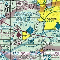
| Sectional chart |
|---|
|
CAUTION: Diagram may not be current
 Download PDF
of official airport diagram from the FAA
| Airport distance calculator |
|---|
|
|
| Sunrise and sunset |
|---|
|
Times for 04-Apr-2026
| | Local
(UTC-5) | | Zulu
(UTC) |
|---|
| Morning civil twilight | | 06:34 | | 11:34 |
| Sunrise | | 07:01 | | 12:01 |
| Sunset | | 19:45 | | 00:45 |
| Evening civil twilight | | 20:12 | | 01:12 |
|
| Current date and time |
|---|
| Zulu (UTC) | 04-Apr-2026 07:44:25 |
|---|
| Local (UTC-5) | 04-Apr-2026 02:44:25 |
|---|
|
| METAR |
|---|
| KIXD | 040716Z AUTO 31008KT 10SM BKN007 06/05 A3003 RMK AO2 T00610050
|
KOJC
7nm E | 040705Z AUTO 32006KT 10SM SCT008 BKN100 06/05 A3001 RMK AO2 T00610050
|
KGVW
15nm E | 040725Z AUTO 12016KT 5SM HZ CLR A3001 RMK A01
|
KLWC
19nm NW | 040652Z AUTO 32012KT 10SM CLR 06/04 A3003 RMK AO1 SLP168 T00560039
|
|
| TAF |
|---|
| KIXD | 040520Z 0406/0506 31012KT P6SM OVC008 FM041300 31014G22KT P6SM OVC012 FM041600 30018G27KT P6SM SCT025 BKN250 FM050000 31008KT P6SM FEW250
|
|
| NOTAMs |
|---|
NOTAMs are issued by the DoD/FAA and will open in a separate window not controlled by AirNav.
|
|


