FAA INFORMATION EFFECTIVE 21 MARCH 2024
Location
| FAA Identifier: | BHB |
| Lat/Long: | 44-26-58.9390N 068-21-41.3630W
44-26.982317N 068-21.689383W
44.4497053,-68.3614897
(estimated) |
| Elevation: | 83.2 ft. / 25.4 m (surveyed) |
| Variation: | 19W (1985) |
| From city: | 8 miles NW of BAR HARBOR, ME |
| Time zone: | UTC -4 (UTC -5 during Standard Time) |
| Zip code: | 04605 |
Airport Operations
| Airport use: | Open to the public |
| Activation date: | 04/1940 |
| Control tower: | no |
| ARTCC: | BOSTON CENTER |
| FSS: | BANGOR FLIGHT SERVICE STATION |
| NOTAMs facility: | BHB (NOTAM-D service available) |
| Attendance: | 0800-1800 |
| Wind indicator: | yes |
| Segmented circle: | yes |
| Lights: | ACTVT MALSF RWY 22; REIL RWY 04; VASI RWY 04 & 22; HIRL RWY 04/22 - 122.7. |
| Beacon: | white-green (lighted land airport)
Operates sunset to sunrise. |
| Fire and rescue: | ARFF index A |
Airport Communications
| CTAF/UNICOM: | 123.0 |
| WX AWOS-3PT: | 118.35 (207-667-7364) |
| BANGOR APPROACH: | 133.6 |
| BANGOR DEPARTURE: | 133.6 |
| CLEARANCE DELIVERY: | 119.9 |
| IC: | 133.6 |
Nearby radio navigation aids
| VOR radial/distance | | VOR name | | Freq | | Var |
|---|
| BGRr156/32.1 | | BANGOR VORTAC | | 114.80 | | 19W |
Airport Services
| Fuel available: | 100LL JET-A |
| Parking: | hangars and tiedowns |
| Airframe service: | MINOR |
| Powerplant service: | MINOR |
| Bottled oxygen: | LOW |
| Bulk oxygen: | NONE |
Runway Information
Runway 4/22
| Dimensions: | 5200 x 100 ft. / 1585 x 30 m |
| Surface: | asphalt, in good condition |
| Weight bearing capacity: | | PCN 40 /F/D/X/T | | Double wheel: | 72.0 | | Double tandem: | 100.0 |
|
| Runway edge lights: | high intensity |
| Operational restrictions: | DUE TO HUMP AT MIDPT, OPPOSITE ENDS OF RWY NOT VSB AT GND LEVEL. |
| RUNWAY 4 | | RUNWAY 22 |
| Latitude: | 44-26.631513N | | 44-27.409648N |
| Longitude: | 068-22.038093W | | 068-21.540717W |
| Elevation: | 69.0 ft. | | 69.1 ft. |
| Traffic pattern: | left | | left |
| Runway heading: | 044 magnetic, 025 true | | 224 magnetic, 205 true |
| Declared distances: | TORA:5200 TODA:5200 ASDA:5200 LDA:5200 | | TORA:5200 TODA:5200 ASDA:5200 LDA:5200 |
| Markings: | nonprecision, in good condition | | precision, in good condition |
| Visual slope indicator: | 4-box VASI on left (3.00 degrees glide path) | | 4-box VASI on left (3.00 degrees glide path) |
| Approach lights: | | | MALSF: 1,400 foot medium intensity approach lighting system with sequenced flashers |
| Runway end identifier lights: | yes | | no |
| Touchdown point: | yes, no lights | | yes, no lights |
| Instrument approach: | | | ILS/DME |
| Obstructions: | 125 ft. trees, 1410 ft. from runway, 500 ft. left of centerline, 9:1 slope to clear | | none |
Runway 17/35
| Dimensions: | 3363 x 75 ft. / 1025 x 23 m |
| Surface: | asphalt, in good condition |
| Weight bearing capacity: | | Single wheel: | 13.0 | | Double wheel: | 20.0 |
|
| Operational restrictions: | NOT AVBL FOR SKEDD ACR OPS (LDG & TKOF) MORE THAN 9 PAX SEATS OR UNSKED ACR OPS AT LEAST 31 PAX SEATS. RWY 17/35 N OF TWY H AVBL FOR ACR OPS MORE THAN 9 PAX SEATS FOR TAXI ONLY. |
| RUNWAY 17 | | RUNWAY 35 |
| Latitude: | 44-27.161850N | | 44-26.684467N |
| Longitude: | 068-21.730515W | | 068-21.338983W |
| Elevation: | 78.6 ft. | | 43.0 ft. |
| Traffic pattern: | left | | left |
| Runway heading: | 169 magnetic, 150 true | | 349 magnetic, 330 true |
| Displaced threshold: | 684 ft. | | 111 ft. |
| Markings: | basic, in good condition | | basic, in good condition |
| Runway end identifier lights: | no | | no |
| Touchdown point: | yes, no lights | | yes, no lights |
| Obstructions: | 148 ft. tree, 900 ft. from runway, 60 ft. right of centerline, 5:1 slope to clear
10:1 TO DTHR. | | none |
Airport Ownership and Management from official FAA records
| Ownership: | Publicly-owned |
| Owner: | HANCOCK COUNTY
50 STATE ST, STE 7
ELLSWORTH, ME 04605
Phone 207-667-9542 |
| Manager: | LEROY MUISE
115 CARUSO DR
TRENTON, ME 04605
Phone 207-667-7329 |
Airport Operational Statistics
| Aircraft based on the field: | | 23 | | Single engine airplanes: | | 22 | | Helicopters: | | 1 |
| |  | |
| Aircraft operations: avg 66/day * | | 52% | local general aviation | | 30% | transient general aviation | | 18% | air taxi | | <1% | military | | * for 12-month period ending 26 August 2022 | |
Additional Remarks
| - | FICON NOT MNT MON-FRI 2100-0730, WKENDS & HOLS. |
| - | IF CD FREQ UNAVBL CTC BANGOR APCH AT 207-561-2500 EXT 1. |
| - | GRASS AREAS UNAVBL FOR ACFT OPS. |
| - | 48 HR PPR FOR UNSKED ACR OPS AT LEAST 31 PAX SEATS. CTC AMGR. |
| - | BIRDS ON & INVOF ARPT. |
| - | DURG VFR CONDS WHEN WIND SPEED LESS THAN 5 KTS AS RPRTD BY AWOS OR UNICOM, ALL ACFT USING RWY 04/22 ARE REQD TO TKOF & LAND ON RWY 22 FOR NOISE ABATEMENT PROCS. |
| - | TWY BRAVO CLSD TO ALL ACFT GTR THAN 10000 LBS. |
| - | PPR FOR OVERWEIGHT LDGS. PPR FOR UNSKED ACR OPS RQRG 14 CFR 139 ARFF. CTC AMGR. |
| - | TWYS F & G CLSD DEC 1- MAR 31 ANNUALLY. |
| - | SEAPLANE RAMP UNAVBL FOR ACFT OPS EXC PPR 207-667-7329. |
Instrument Procedures
NOTE: All procedures below are presented as PDF files. If you need a reader for these files, you should download the free Adobe Reader.NOT FOR NAVIGATION. Please procure official charts for flight.
FAA instrument procedures published for use from 21 March 2024 at 0901Z to 18 April 2024 at 0900z.
IAPs - Instrument Approach Procedures |
|---|
| ILS OR LOC RWY 22 | |
download (270KB) |
| RNAV (GPS) RWY 04 | |
download (267KB) |
| RNAV (GPS) RWY 22 | |
download (299KB) |
| NOTE: Special Alternate Minimums apply | |
download (128KB) |
| NOTE: Special Take-Off Minimums/Departure Procedures apply | |
download (492KB) |
Other nearby airports with instrument procedures:
43B - Deblois Flight Strip (23 nm NE)
KBST - Belfast Municipal Airport (28 nm W)
KBGR - Bangor International Airport (29 nm NW)
KOLD - Dewitt Field/Old Town Municipal Airport (33 nm NW)
KRKD - Knox County Regional Airport (39 nm SW)
|
|

Road maps at:
MapQuest
Bing
Google
| Aerial photo |
|---|
WARNING: Photo may not be current or correct
 Photo by Pete Chaisson Portland Flight Services
Taken in June 2014
looking west.
Photo by Pete Chaisson Portland Flight Services
Taken in June 2014
looking west.
Do you have a better or more recent aerial photo of Hancock County/Bar Harbor Airport that you would like to share? If so, please send us your photo.
|
| Sectional chart |
|---|
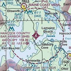
|
CAUTION: Diagram may not be current

| Airport distance calculator |
|---|
|
|
| Sunrise and sunset |
|---|
|
Times for 18-Apr-2024
| | Local
(UTC-4) | | Zulu
(UTC) |
|---|
| Morning civil twilight | | 05:13 | | 09:13 |
| Sunrise | | 05:44 | | 09:44 |
| Sunset | | 19:21 | | 23:21 |
| Evening civil twilight | | 19:52 | | 23:52 |
|
| Current date and time |
|---|
| Zulu (UTC) | 18-Apr-2024 11:38:00 |
|---|
| Local (UTC-4) | 18-Apr-2024 07:38:00 |
|---|
|
| METAR |
|---|
| KBHB | 181056Z AUTO 36003KT 10SM CLR 02/01 A3023 RMK AO2 SLP240 T00220011 FZRANO
|
|
| TAF |
|---|
| KBHB | 180528Z 1806/1906 00000KT P6SM SKC FM181400 08005KT P6SM FEW070 FM182000 16006KT P6SM SKC
|
|
| NOTAMs |
|---|
NOTAMs are issued by the DoD/FAA and will open in a separate window not controlled by AirNav.
|
|


