FAA INFORMATION EFFECTIVE 14 MAY 2026
Location
| FAA Identifier: | CFS |
| Lat/Long: | 43-27-31.8990N 083-26-43.6080W
43-27.531650N 083-26.726800W
43.4588608,-83.4454467
(estimated) |
| Elevation: | 704.3 ft. / 214.7 m (surveyed) |
| Variation: | 08W (2020) |
| From city: | 3 miles SW of CARO, MI |
| Time zone: | UTC -4 (UTC -5 during Standard Time) |
| Zip code: | 48723 |
Airport Operations
| Airport use: | Open to the public |
| Activation date: | 09/1944 |
| Control tower: | no |
| ARTCC: | CLEVELAND CENTER |
| FSS: | LANSING FLIGHT SERVICE STATION |
| NOTAMs facility: | CFS (NOTAM-D service available) |
| Attendance: | IREG |
| Wind indicator: | lighted |
| Segmented circle: | yes |
| Lights: | ACTVT PAPI RWY 06 & 24; MIRL RWY 06/24 - CTAF. PAPI RWY 06 & 24 OPR CONSLY DAWN-DUSK. |
| Beacon: | white-green (lighted land airport)
Operates sunset to sunrise. |
Airport Communications
| CTAF/UNICOM: | 123.0 |
| WX AWOS-3P: | 119.275 (989-672-4182) |
| GREAT LAKES APPROACH: | 120.95 |
| GREAT LAKES DEPARTURE: | 120.95 |
| WX AWOS-3P at HYX (18 nm W): | 118.325 (989-752-3408) |
- APCH/DEP SVC PRVDD BY CLEVELAND ARTCC (ZOB) ON FREQS 127.7/290.425 (FREELAND RCAG) WHEN GREAT LAKES APCH CTL CLSD.
Nearby radio navigation aids
| VOR radial/distance | | VOR name | | Freq | | Var |
|---|
| MBSr102/27.8 | | SAGINAW VOR/DME | | 114.35 | | 03W |
| FNTr030/32.3 | | FLINT VORTAC | | 116.90 | | 06W |
Airport Services
| Fuel available: | 100LL JET-A+ |
| Parking: | hangars and tiedowns |
| Airframe service: | MAJOR |
| Powerplant service: | MAJOR |
| Bottled oxygen: | NONE |
| Bulk oxygen: | NONE |
Runway Information
Runway 6/24
| Dimensions: | 4302 x 75 ft. / 1311 x 23 m |
| Surface: | asphalt, in excellent condition |
| Runway edge lights: | medium intensity |
| RUNWAY 6 | | RUNWAY 24 |
| Latitude: | 43-27.242665N | | 43-27.693608N |
| Longitude: | 083-27.222020W | | 083-26.472463W |
| Elevation: | 684.8 ft. | | 700.5 ft. |
| Traffic pattern: | left | | left |
| Runway heading: | 058 magnetic, 050 true | | 238 magnetic, 230 true |
| Markings: | nonprecision, in good condition | | nonprecision, in good condition |
| Visual slope indicator: | 4-light PAPI on left (3.00 degrees glide path)
PAPI UNUSBL BYD 9 DEGS LEFT OF CNTRLN. | | 4-light PAPI on left (3.50 degrees glide path) |
| Runway end identifier lights: | no | | no |
| Touchdown point: | yes, no lights | | yes, no lights |
| Obstructions: | 60 ft. tree, 1215 ft. from runway, 265 ft. right of centerline, 16:1 slope to clear | | 48 ft. tree, 793 ft. from runway, 300 ft. right of centerline, 12:1 slope to clear |
Runway 13/31
| Dimensions: | 2277 x 110 ft. / 694 x 34 m |
| Surface: | turf, in fair condition |
| Runway edge markings: | 3 FT YELLOW CONES. |
| RUNWAY 13 | | RUNWAY 31 |
| Latitude: | 43-27.744598N | | 43-27.558688N |
| Longitude: | 083-26.722463W | | 083-26.275807W |
| Elevation: | 704.3 ft. | | 689.0 ft. |
| Traffic pattern: | left | | left |
| Runway heading: | 128 magnetic, 120 true | | 308 magnetic, 300 true |
| Displaced threshold: | no | | 564 ft. |
| Touchdown point: | yes, no lights | | yes, no lights |
| Obstructions: | 1 ft. brush, 125 ft. right of centerline
CTLNG OBSTN EXCEEDS A 45 DEG SLP. | | 78 ft. tree, 1054 ft. from runway, 40 ft. right of centerline, 13:1 slope to clear
APCH RATIO 20:1 TO DTHR. |
Airport Ownership and Management from official FAA records
| Ownership: | Publicly-owned |
| Owner: | TUSCOLA AREA AIRPORT AUTHORITY
1750 SPEIRS RD
CARO, MI 48723-8211
Phone 989-673-4301 |
| Manager: | JOE GREENE
1750 SPEIRS RD
CARO, MI 48723-8211
Phone 989-670-2441 |
Additional Remarks
| - | DEER & LRG BIRDS ON & INVOF ARPT. |
| - | RC ACFT OPS S OF RWY INT. |
| - | FOR CD CTC GREAT LAKES APCH AT 269-459-3345, WHEN APCH CLSD CTC CLEVELAND ARTCC AT 440-774-0224/0490. |
Instrument Procedures
NOTE: All procedures below are presented as PDF files. If you need a reader for these files, you should download the free Adobe Reader.NOT FOR NAVIGATION. Please procure official charts for flight.
FAA instrument procedures published for use from 14 May 2026 at 0901Z to 11 June 2026 at 0900Z.
IAPs - Instrument Approach Procedures |
|---|
| RNAV (GPS) RWY 06 | |
download (192KB) |
| RNAV (GPS) RWY 24 | |
download (199KB) |
| NOTE: Special Alternate Minimums apply **CHANGED** | |
download (140KB) |
| NOTE: Special Take-Off Minimums/Departure Procedures apply | |
download (349KB) |
Other nearby airports with instrument procedures:
77G - Marlette Township Airport (18 nm SE)
KHYX - Saginaw County/H W Browne Airport (18 nm W)
3CM - James Clements Municipal Airport (20 nm W)
D95 - Dupont/Lapeer Airport (25 nm S)
Y83 - Sandusky City Airport (26 nm E)
|
|

Road maps at:
MapQuest
Bing
Google
| Aerial photo |
|---|
WARNING: Photo may not be current or correct
 Photo by Kevin Jarchow, USCG Auxiliary. Flotilla Holland, MI
Photo taken 15-Aug-2015
looking northwest.
Photo by Kevin Jarchow, USCG Auxiliary. Flotilla Holland, MI
Photo taken 15-Aug-2015
looking northwest.
Do you have a better or more recent aerial photo of Tuscola Area Airport that you would like to share? If so, please send us your photo.
|
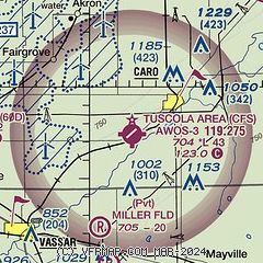
| Sectional chart |
|---|
|
| Airport distance calculator |
|---|
|
|
| Sunrise and sunset |
|---|
|
Times for 08-Jun-2026
| | Local
(UTC-4) | | Zulu
(UTC) |
|---|
| Morning civil twilight | | 05:19 | | 09:19 |
| Sunrise | | 05:54 | | 09:54 |
| Sunset | | 21:11 | | 01:11 |
| Evening civil twilight | | 21:47 | | 01:47 |
|
| Current date and time |
|---|
| Zulu (UTC) | 08-Jun-2026 21:06:38 |
|---|
| Local (UTC-4) | 08-Jun-2026 17:06:38 |
|---|
|
| METAR |
|---|
| KCFS | 082055Z AUTO 14008KT 10SM CLR 29/14 A3006 RMK AO2
|
KHYX
18nm W | 082055Z AUTO VRB04KT 10SM CLR 30/12 A3005 RMK AO2
|
|
| TAF |
|---|
KMBS
28nm W | 081739Z 0818/0918 12008KT P6SM FEW050 BKN250 FM090300 14006KT P6SM BKN050 OVC080 TEMPO 0906/0909 4SM -SHRA BKN035 BKN060 FM090900 15005KT P6SM BKN025 BKN050 TEMPO 0909/0913 2SM -TSRA BKN025CB BKN050 FM091300 18007KT P6SM BKN025 BKN050 FM091500 17008KT 4SM -SHRA BR OVC015
|
KFNT
32nm SW | 081739Z 0818/0918 12008KT P6SM FEW050 BKN250 FM090300 14006KT P6SM BKN050 OVC080 TEMPO 0906/0909 4SM -SHRA BKN035 BKN060 FM090900 15005KT P6SM BKN025 BKN050 TEMPO 0909/0913 2SM -TSRA BKN025CB BKN050 FM091300 18007KT P6SM BKN025 BKN050 FM091500 17008KT 4SM -SHRA BR OVC015
|
|
| NOTAMs |
|---|
NOTAMs are issued by the DoD/FAA and will open in a separate window not controlled by AirNav.
|
|

