FAA INFORMATION EFFECTIVE 15 MAY 2025
Location
| FAA Identifier: | CGE |
| Lat/Long: | 38-32-21.5570N 076-01-49.4230W
38-32.359283N 076-01.823717W
38.5393214,-76.0303953
(estimated) |
| Elevation: | 19.6 ft. / 6.0 m (surveyed) |
| Variation: | 10W (1985) |
| From city: | 3 miles SE of CAMBRIDGE, MD |
| Time zone: | UTC -4 (UTC -5 during Standard Time) |
| Zip code: | 21613 |
Airport Operations
| Airport use: | Open to the public |
| Activation date: | 12/1936 |
| Control tower: | no |
| ARTCC: | WASHINGTON CENTER |
| FSS: | LEESBURG FLIGHT SERVICE STATION |
| NOTAMs facility: | DCA (NOTAM-D service available) |
| Attendance: | 0800-1700
UNATNDD THANKSGIVING, CHRISTMAS & NEW YEARS DAY. |
| Wind indicator: | lighted |
| Segmented circle: | yes |
| Lights: | ACTVT REIL RWY 16 & 34; PAPI RWY 16 & 34; MIRL RWY 16/34 - 121.9. |
| Beacon: | white-green (lighted land airport)
Operates sunset to sunrise. |
Airport Communications
| CTAF/UNICOM: | 122.7 |
| WX AWOS-3: | 120.675 (410-228-7559) |
| PATUXENT APPROACH: | 121.0 |
| POTOMAC APPROACH: | 135.625 ;WHEN NHK APCH CLSD |
| PATUXENT DEPARTURE: | 121.0 |
| POTOMAC DEPARTURE: | 135.625 ;WHEN NHK APCH CLSD |
| WX AWOS-3PT at ESN (16 nm N): | 124.475 (410-822-2817) |
- APCH/DEP SVC PRVDD BY POTOMAC TRACON ON 135.625/269.625 WHEN PATUXENT APCH CTL CLSD.
Nearby radio navigation aids
| VOR radial/distance | | VOR name | | Freq | | Var |
|---|
| SBYr308/27.1 | | SALISBURY VORTAC | | 111.20 | | 12W |
| SWLr325/39.4 | | SNOW HILL VORTAC | | 112.40 | | 08W |
| NDB name | | Hdg/Dist | | Freq | | Var | | ID |
|---|
| PATUXENT | | 059/23.2 | | 400 | | 10W | | NHK | -. .... -.- |
Airport Services
| Fuel available: | 100LL JET-A |
| Parking: | hangars and tiedowns |
| Airframe service: | NONE |
| Powerplant service: | NONE |
Runway Information
Runway 16/34
| Dimensions: | 4477 x 75 ft. / 1365 x 23 m |
| Surface: | asphalt/grooved, in good condition |
| Weight bearing capacity: | |
| Runway edge lights: | medium intensity |
| RUNWAY 16 | | RUNWAY 34 |
| Latitude: | 38-32.656955N | | 38-32.061585N |
| Longitude: | 076-02.100943W | | 076-01.546527W |
| Elevation: | 18.5 ft. | | 15.7 ft. |
| Traffic pattern: | left | | left |
| Runway heading: | 154 magnetic, 144 true | | 334 magnetic, 324 true |
| Markings: | nonprecision, in good condition | | nonprecision, in good condition |
| Visual slope indicator: | 2-light PAPI on left (3.50 degrees glide path) | | 2-light PAPI on left (3.25 degrees glide path) |
| Runway end identifier lights: | yes | | yes |
| Touchdown point: | yes, no lights | | yes, no lights |
| Obstructions: | 61 ft. trees, 1564 ft. from runway, 22:1 slope to clear | | 15 ft. road, lighted, 440 ft. from runway, 250 ft. left of centerline, 16:1 slope to clear |
Airport Ownership and Management from official FAA records
| Ownership: | Publicly-owned |
| Owner: | DORCHESTER COUNTY CMSNRS
501 COURT LA
CAMBRIDGE, MD 21613
Phone 410-228-1700 |
| Manager: | STEVE NUWER
5263 BUCKTOWN RD
CAMBRIDGE, MD 21613
Phone 410-228-4571 |
Additional Remarks
| - | BIRDS AND/OR WILDLIFE ON AND INVOF ARPT. |
| - | FOR CD CTC PATUXENT APCH AT 301-342-3740, WHEN PATUXENT APCH IS CLSD CTC POTOMAC APCH AT 866-640-4124. |
Instrument Procedures
NOTE: All procedures below are presented as PDF files. If you need a reader for these files, you should download the free Adobe Reader.NOT FOR NAVIGATION. Please procure official charts for flight.
FAA instrument procedures published for use from 15 May 2025 at 0901Z to 13 June 2025 at 0900z.
IAPs - Instrument Approach Procedures |
|---|
| RNAV (GPS) RWY 34 | |
download (248KB) |
| RNAV (GPS)-A **CHANGED** | |
download (257KB) |
| NOTE: Special Alternate Minimums apply | |
download (168KB) |
| NOTE: Special Take-Off Minimums/Departure Procedures apply | |
download (212KB) |
Other nearby airports with instrument procedures:
KESN - Easton Airport/Newnam Field (16 nm N)
N06 - Laurel Airport (20 nm E)
KNHK - Patuxent River Naval Air Station (Trapnell Field) Airport (23 nm SW)
KRJD - Gooden Airpark (27 nm N)
KSBY - Salisbury-Ocean City Wicomico Regional Airport (27 nm SE)
|
|

Road maps at:
MapQuest
Bing
Google
| Aerial photo |
|---|
WARNING: Photo may not be current or correct
 Photo taken 24-Aug-2016
looking north-northeast.
Photo taken 24-Aug-2016
looking north-northeast.
Do you have a better or more recent aerial photo of Cambridge-Dorchester Regional Airport that you would like to share? If so, please send us your photo.
|
| Sectional chart |
|---|
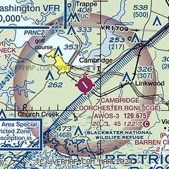
|
| Airport distance calculator |
|---|
|
|
| Sunrise and sunset |
|---|
|
Times for 17-May-2025
| | Local
(UTC-4) | | Zulu
(UTC) |
|---|
| Morning civil twilight | | 05:22 | | 09:22 |
| Sunrise | | 05:52 | | 09:52 |
| Sunset | | 20:09 | | 00:09 |
| Evening civil twilight | | 20:39 | | 00:39 |
|
| Current date and time |
|---|
| Zulu (UTC) | 17-May-2025 09:43:44 |
|---|
| Local (UTC-4) | 17-May-2025 05:43:44 |
|---|
|
| METAR |
|---|
| KCGE | 170915Z AUTO 00000KT 10SM OVC085 22/19 A2970 RMK A01
|
KESN
16nm N | 170915Z AUTO 20003KT 10SM CLR 20/20 A2968 RMK AO2 T02040196
|
|
| TAF |
|---|
KNHK
24nm SW | 1707/1807 22008G15KT 9999 BKN060 BKN130 QNH2969INS BECMG 1708/1710 23010G15KT 9999 BKN140 BKN180 QNH2968INS BECMG 1713/1715 26010G17KT 9999 FEW090 QNH2966INS AUTOMATED SENSOR METWATCH 1707 TIL 1708 TX26/1721Z TN19/1709Z FN00277
|
KSBY
28nm SE | 170658Z 1707/1806 23007KT P6SM VCTS BKN050CB PROB30 1711/1714 VRB15G35KT 3SM TSRA OVC035CB FM171400 24015G24KT P6SM SCT050 BKN250 FM172300 27008KT P6SM SKC
|
|
| NOTAMs |
|---|
NOTAMs are issued by the DoD/FAA and will open in a separate window not controlled by AirNav.
|
|


