FAA INFORMATION EFFECTIVE 02 OCTOBER 2025
Location
| FAA Identifier: | CKB |
| Lat/Long: | 39-17-51.5570N 080-13-39.1150W
39-17.859283N 080-13.651917W
39.2976547,-80.2275319
(estimated) |
| Elevation: | 1223.5 ft. / 372.9 m (surveyed) |
| Variation: | 08W (1995) |
| From city: | 1 mile NE of CLARKSBURG, WV |
| Time zone: | UTC -4 (UTC -5 during Standard Time) |
| Zip code: | 26330 |
Airport Operations
| Airport use: | Open to the public |
| Activation date: | 06/1938 |
| Control tower: | yes |
| ARTCC: | CLEVELAND CENTER |
| FSS: | ELKINS FLIGHT SERVICE STATION [703-724-4288] |
| NOTAMs facility: | CKB (NOTAM-D service available) |
| Attendance: | 0700-2300 |
| Wind indicator: | lighted |
| Segmented circle: | no |
| Lights: | ACTVT MALSR RWY 21; REIL RWY 03; PAPI RWY 03 & 21; AND HIRL RWY 3/21 ON CTAF. |
| Beacon: | white-green (lighted land airport)
Operates sunset to sunrise. |
| Landing fee: | yes, LNDG FEE FOR ALL ACFT OVER 6500 LBS. |
| Fire and rescue: | ARFF index B |
| Airline operations: | PPR 24 HRS FOR UNSKED ACR OPNS WITH MORE THAN 30 PSGR SEATS CALL AMGR 304-842-3400 OR 304-848-6700. |
Airport Communications
| CTAF: | 126.7 |
| UNICOM: | 123.0 |
| ATIS: | 127.825 |
| WX ASOS: | PHONE 304-842-9240 |
| CLARKSBURG GROUND: | 121.9 [0700-2300] |
| CLARKSBURG TOWER: | 126.7 257.925 [0700-2300] |
| CLARKSBURG APPROACH: | 121.15 284.65 [0700-2300] |
| CLARKSBURG DEPARTURE: | 121.15 284.65 [0700-2300] |
| ARNG OPS: | 123.425 |
| EMERG: | 121.5 243.0 |
| WX AWOS-3 at W22 (18 nm S): | 119.975 (304-472-9428) |
- APCH/DEP SVC PRVDD BY CLEVELAND ARTCC (ZOB) ON FREQS 126.95/239.3 (BELMONT RCAG) WHEN CLARKSBURG APCH CTL CLSD.
Nearby radio navigation aids
| VOR radial/distance | | VOR name | | Freq | | Var |
|---|
| CKBr039/3.3 | | CLARKSBURG VOR/DME | | 112.60 | | 04W |
| MGWr233/23.0 | | MORGANTOWN VOR/DME | | 111.60 | | 05W |
| EKNr352/23.8 | | ELKINS VORTAC | | 114.20 | | 07W |
| NDB name | | Hdg/Dist | | Freq | | Var | | ID |
|---|
| RANDOLPH COUNTY | | 332/29.7 | | 284 | | 07W | | RQY | .-. --.- -.-- |
Airport Services
| Fuel available: | 100LL JET-A
100LL:FUEL NOT AVBL DURG HRS 2300-0500. |
| Parking: | hangars and tiedowns |
| Airframe service: | MAJOR |
| Powerplant service: | MAJOR |
| Bottled oxygen: | NONE |
| Bulk oxygen: | NONE |
Runway Information
Runway 3/21
| Dimensions: | 7800 x 150 ft. / 2377 x 46 m |
| Surface: | asphalt/grooved, in good condition |
| Weight bearing capacity: | | PCN 46 /F/B/X/U | | Single wheel: | 80.0 | | Double wheel: | 125.0 | | Double tandem: | 180.0 | | Dual double tandem: | 180.0 |
|
| Runway edge lights: | high intensity |
| RUNWAY 3 | | RUNWAY 21 |
| Latitude: | 39-17.267208N | | 39-18.451417N |
| Longitude: | 080-13.972695W | | 080-13.331083W |
| Elevation: | 1183.1 ft. | | 1223.5 ft. |
| Traffic pattern: | left | | left |
| Runway heading: | 031 magnetic, 023 true | | 211 magnetic, 203 true |
| Displaced threshold: | 670 ft. | | no |
| Declared distances: | TORA:7800 TODA:7800 ASDA:7800 LDA:7130 | | TORA:7800 TODA:7800 ASDA:7130 LDA:7130 |
| Markings: | precision, in good condition | | precision, in good condition |
| Visual slope indicator: | 4-light PAPI on left (3.44 degrees glide path) | | 4-light PAPI on left (3.00 degrees glide path) |
| RVR equipment: | rollout | | touchdown |
| Approach lights: | | | MALSR: 1,400 foot medium intensity approach lighting system with runway alignment indicator lights |
| Runway end identifier lights: | yes | | |
| Touchdown point: | yes, no lights | | yes, no lights |
| Instrument approach: | | | ILS |
| Obstructions: | 43 ft. trees, 600 ft. from runway, 525 ft. right of centerline, 9:1 slope to clear | | 189 ft. trees, 6500 ft. from runway, 300 ft. right of centerline, 33:1 slope to clear |
Helipad H1
| Dimensions: | 50 x 50 ft. / 15 x 15 m |
| Surface: | concrete, in fair condition
HELI, H-1 SFC COND FAIR, PAVEMENT CRACKING. |
| Latitude: | 39-17.831167N | | |
| Longitude: | 080-13.800500W | | |
| Elevation: | 1180.0 ft. | | |
| Traffic pattern: | left | | left |
Airport Ownership and Management from official FAA records
| Ownership: | Publicly-owned |
| Owner: | BENEDUM AIRPORT AUTHORITY
2000 AVIATION WAY
BRIDGEPORT, WV 26330
Phone 304-842-3400 |
| Manager: | RICK ROCK
2000 AVIATION WAY
BRIDGEPORT, WV 26330
Phone 304-842-3400 |
Additional Remarks
| - | DEER & BIRDS ON & INVOF ARPT. |
| - | AFT HRS FOR EMERGS CALL 304-623-6559. |
| - | FOR CD CTC CLARKSBURG APCH AT 304-842-2011, WHEN APCH CLSD CTC CLEVELAND ARTCC AT 440-774-0226. |
| - | TWY A SOUTH OF TWY C, MAIN TRML APRON, AND HELIPAD NOT VSBL FROM TWR. |
| - | 24 PPR FOR PRK ON ARNG RAMP DSN 661-3800 C304-201-3800. |
| - | TWY H E OF TWY H1 CLSD TO TRAN ACFT. |
| - | CTLNG OBSTN SLOPE AT DSPLCD LOCATION RWY 03 IS 29:1. |
Instrument Procedures
NOTE: All procedures below are presented as PDF files. If you need a reader for these files, you should download the free Adobe Reader.NOT FOR NAVIGATION. Please procure official charts for flight.
FAA instrument procedures published for use from 02 October 2025 at 0901Z to 30 October 2025 at 0900z.
IAPs - Instrument Approach Procedures |
|---|
| ILS OR LOC RWY 21 | |
download (308KB) |
| RNAV (GPS) RWY 03 | |
download (247KB) |
| RNAV (GPS) RWY 21 | |
download (244KB) |
| VOR-A | |
download (208KB) |
| NOTE: Special Alternate Minimums apply | |
download (44KB) |
| NOTE: Special Take-Off Minimums/Departure Procedures apply | |
download (149KB) |
Other nearby airports with instrument procedures:
4G7 - Fairmont Municipal Airport-Frankman Field (9 nm N)
79D - Philippi/Barbour County Regional Airport (11 nm SE)
W22 - Upshur County Regional Airport (18 nm S)
KMGW - Morgantown Municipal Airport/Walter L Bill Hart Field (25 nm NE)
KEKN - Elkins-Randolph County Airport-Jennings Randolph Field (30 nm SE)
|
|

Road maps at:
MapQuest
Bing
Google
| Aerial photo |
|---|
WARNING: Photo may not be current or correct
 Photo courtesy of North Central WV Airport (CKB)
Do you have a better or more recent aerial photo of North Central West Virginia Airport that you would like to share? If so, please send us your photo.
|
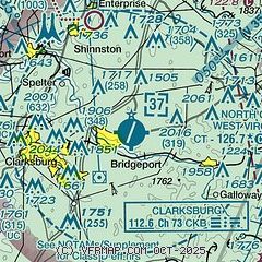
| Sectional chart |
|---|
|
 Download PDF
of official airport diagram from the FAA
| Airport distance calculator |
|---|
|
|
| Sunrise and sunset |
|---|
|
Times for 02-Oct-2025
| | Local
(UTC-4) | | Zulu
(UTC) |
|---|
| Morning civil twilight | | 06:52 | | 10:52 |
| Sunrise | | 07:19 | | 11:19 |
| Sunset | | 19:02 | | 23:02 |
| Evening civil twilight | | 19:28 | | 23:28 |
|
| Current date and time |
|---|
| Zulu (UTC) | 02-Oct-2025 20:15:34 |
|---|
| Local (UTC-4) | 02-Oct-2025 16:15:34 |
|---|
|
| METAR |
|---|
| KCKB | 021953Z 31005KT 10SM CLR 24/08 A3029 RMK AO2 SLP248 T02440078
|
KW22
18nm S | 021955Z AUTO 11004KT 10SM CLR 29/09 A3030 RMK AO2
|
|
| TAF |
|---|
| KCKB | 021720Z 0218/0318 00000KT P6SM FEW250
|
|
| NOTAMs |
|---|
NOTAMs are issued by the DoD/FAA and will open in a separate window not controlled by AirNav.
|
|


