FAA INFORMATION EFFECTIVE 10 JULY 2025
Location
| FAA Identifier: | CKN |
| Lat/Long: | 47-50-29.9660N 096-37-17.2330W
47-50.499433N 096-37.287217W
47.8416572,-96.6214536
(estimated) |
| Elevation: | 900.3 ft. / 274.4 m (surveyed) |
| Variation: | 07E (1980) |
| From city: | 4 miles N of CROOKSTON, MN |
| Time zone: | UTC -5 (UTC -6 during Standard Time) |
| Zip code: | 56716 |
Airport Operations
| Airport use: | Open to the public |
| Activation date: | 04/1947 |
| Control tower: | no |
| ARTCC: | MINNEAPOLIS CENTER |
| FSS: | PRINCETON FLIGHT SERVICE STATION |
| NOTAMs facility: | CKN (NOTAM-D service available) |
| Attendance: | MON-FRI 0800-1700
FOR SVC AFT HRS CALL 218-693-1095. |
| Pattern altitude: | 1700.3 ft. MSL |
| Wind indicator: | lighted |
| Segmented circle: | no |
| Lights: | ACTVT REIL RWY 13 & 31; PAPI RWY 13; MIRL RWY 13/31 - CTAF. PAPI RWY 31 OPR CONSLY. |
| Beacon: | white-green (lighted land airport)
Operates sunset to sunrise. |
Airport Communications
| CTAF/UNICOM: | 122.7 |
| WX AWOS-3: | 126.425 (218-281-3018) |
| GRAND FORKS APPROACH: | 118.1 |
| GRAND FORKS DEPARTURE: | 118.1 |
- APCH/DEP SVC PRVDD BY MINNEAPOLIS ARTCC (ZMP) ON FREQ 132.15/269.6 (GRAND FORKS RCAG) WHEN GRAND FORKS (RDR) APCH CTL CLSD.
Nearby radio navigation aids
| VOR radial/distance | | VOR name | | Freq | | Var |
|---|
| TVFr224/22.2 | | THIEF RIVER FALLS VOR/DME | | 114.45 | | 08E |
| GFKr098/23.7 | | GRAND FORKS VOR/DME | | 114.30 | | 09E |
Airport Services
| Fuel available: | 100LL JET-A
100LL:FUEL AVBL H24 VIA CREDIT CARD. |
| Parking: | hangars and tiedowns |
| Airframe service: | MAJOR |
| Powerplant service: | MAJOR |
| Bottled oxygen: | NONE |
| Bulk oxygen: | NONE |
Runway Information
Runway 13/31
| Dimensions: | 4300 x 75 ft. / 1311 x 23 m |
| Surface: | asphalt, in good condition |
| Weight bearing capacity: | | Single wheel: | 11.0 | | Double wheel: | 16.0 |
|
| Runway edge lights: | medium intensity |
| RUNWAY 13 | | RUNWAY 31 |
| Latitude: | 47-50.660918N | | 47-50.161165N |
| Longitude: | 096-37.707477W | | 096-36.964070W |
| Elevation: | 894.7 ft. | | 896.7 ft. |
| Traffic pattern: | left | | left |
| Runway heading: | 128 magnetic, 135 true | | 308 magnetic, 315 true |
| Markings: | nonprecision, in good condition | | nonprecision, in good condition |
| Visual slope indicator: | 4-light PAPI on left (3.00 degrees glide path) | | 4-light PAPI on right (3.00 degrees glide path) |
| Runway end identifier lights: | yes | | yes |
| Touchdown point: | yes, no lights | | yes, no lights |
Runway 17/35
| Dimensions: | 2977 x 200 ft. / 907 x 61 m |
| Surface: | turf, in good condition |
| Runway edge markings: | YELLOW CONES. |
| Operational restrictions: | NOT PLOWED WINTER MONTHS. |
| RUNWAY 17 | | RUNWAY 35 |
| Latitude: | 47-50.751180N | | 47-50.261625N |
| Longitude: | 096-37.329068W | | 096-37.327030W |
| Elevation: | 894.9 ft. | | 892.4 ft. |
| Traffic pattern: | left | | left |
| Runway heading: | 173 magnetic, 180 true | | 353 magnetic, 000 true |
| Touchdown point: | yes, no lights | | yes, no lights |
Runway 6/24
| Dimensions: | 2096 x 200 ft. / 639 x 61 m |
| Surface: | turf, in good condition |
| RUNWAY 6 | | RUNWAY 24 |
| Latitude: | 47-50.603300N | | 47-50.738377N |
| Longitude: | 096-37.365193W | | 096-36.894092W |
| Elevation: | 892.7 ft. | | 900.2 ft. |
| Traffic pattern: | left | | left |
| Runway heading: | 060 magnetic, 067 true | | 240 magnetic, 247 true |
| Touchdown point: | yes, no lights | | yes, no lights |
Airport Ownership and Management from official FAA records
| Ownership: | Publicly-owned |
| Owner: | CITY OF CROOKSTON
124 N BROADWAY
CROOKSTON, MN 56716-1731
Phone 218-281-4503 |
| Manager: | LOWELL MILLER
26305 AIRPORT RD SW
CROOKSTON, MN 56716-9004
Phone 218-281-2625 |
Additional Remarks
| A30A-13 | CALM WIND RWY. |
| - | FOR CD CTC MINNEAPOLIS ARTCC AT 651-463-5588. |
Instrument Procedures
NOTE: All procedures below are presented as PDF files. If you need a reader for these files, you should download the free Adobe Reader.NOT FOR NAVIGATION. Please procure official charts for flight.
FAA instrument procedures published for use from 10 July 2025 at 0901Z to 07 August 2025 at 0900z.
IAPs - Instrument Approach Procedures |
|---|
| RNAV (GPS) RWY 13 | |
download (250KB) |
| RNAV (GPS) RWY 31 | |
download (246KB) |
| VOR/DME RWY 13 | |
download (236KB) |
| NOTE: Special Alternate Minimums apply | |
download (151KB) |
| NOTE: Special Take-Off Minimums/Departure Procedures apply | |
download (404KB) |
Other nearby airports with instrument procedures:
D37 - Warren Municipal Airport (21 nm N)
D14 - Fertile Municipal Airport (22 nm SE)
KTVF - Thief River Falls Regional Airport (22 nm NE)
KGFK - Grand Forks International Airport (23 nm W)
KRDR - Grand Forks Air Force Base (32 nm W)
|
|

Road maps at:
MapQuest
Bing
Google
| Aerial photo |
|---|
WARNING: Photo may not be current or correct
 Photo by Timothy Hannan
Photo taken 16-Sep-2004
from 5500 feet
Photo by Timothy Hannan
Photo taken 16-Sep-2004
from 5500 feet
Do you have a better or more recent aerial photo of Crookston Municipal Airport - Kirkwood Field that you would like to share? If so, please send us your photo.
|
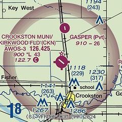
| Sectional chart |
|---|
|
| Airport distance calculator |
|---|
|
|
| Sunrise and sunset |
|---|
|
Times for 16-Jul-2025
| | Local
(UTC-5) | | Zulu
(UTC) |
|---|
| Morning civil twilight | | 05:06 | | 10:06 |
| Sunrise | | 05:45 | | 10:45 |
| Sunset | | 21:20 | | 02:20 |
| Evening civil twilight | | 21:59 | | 02:59 |
|
| Current date and time |
|---|
| Zulu (UTC) | 16-Jul-2025 21:28:16 |
|---|
| Local (UTC-5) | 16-Jul-2025 16:28:16 |
|---|
|
| METAR |
|---|
| KCKN | 162115Z AUTO 02009KT 10SM SCT055 18/10 A3010 RMK AO2
|
|
| TAF |
|---|
KTVF
23nm NE | 161727Z 1618/1718 04011G16KT P6SM SCT035 BKN120 FM170100 02007KT P6SM BKN250 FM170800 VRB03KT P6SM SKC
|
KGFK
24nm W | 161727Z 1618/1718 04012G17KT P6SM SCT040 BKN150 FM170100 36006KT P6SM SKC FM171100 VRB05KT P6SM SKC
|
|
| NOTAMs |
|---|
NOTAMs are issued by the DoD/FAA and will open in a separate window not controlled by AirNav.
|
|


