FAA INFORMATION EFFECTIVE 19 FEBRUARY 2026
Location
| FAA Identifier: | CLE |
| Lat/Long: | 41-24-33.8650N 081-51-16.8880W
41-24.564417N 081-51.281467W
41.4094069,-81.8546911
(estimated) |
| Elevation: | 799.5 ft. / 243.7 m (surveyed) |
| Variation: | 08W (2020) |
| From city: | 9 miles SW of CLEVELAND, OH |
| Time zone: | UTC -5 (UTC -4 during Daylight Saving Time) |
| Zip code: | 44135 |
Airport Operations
| Airport use: | Open to the public |
| Activation date: | 11/1938 |
| Control tower: | yes |
| ARTCC: | CLEVELAND CENTER |
| FSS: | CLEVELAND FLIGHT SERVICE STATION |
| NOTAMs facility: | CLE (NOTAM-D service available) |
| Attendance: | CONTINUOUS |
| Wind indicator: | lighted |
| Segmented circle: | no |
| Beacon: | white-green (lighted land airport)
Operates sunset to sunrise. |
| Landing fee: | yes |
| Fire and rescue: | ARFF index C |
| International operations: | international airport of entry |
Airport Communications
| UNICOM: | 122.95 |
| WX ASOS: | PHONE 216-264-9022 |
| CLEVELAND GROUND: | 121.7 273.45 |
| CLEVELAND TOWER: | 124.5 273.45 |
| CLEVELAND APPROACH: | 126.55 346.325 |
| CLEVELAND DEPARTURE: | 128.25 135.875 346.325 |
| CLEARANCE DELIVERY: | 125.05 273.45 |
| CAVVS DP: | 135.875 |
| CLASS B: | 125.35 ;340-200 126.35 ;201-339 |
| D-ATIS: | 127.85 ;ARR 132.375 ;DEP |
| EMERG: | 121.5 243.0 |
| GTLKE DP: | 128.25 |
| KKIDS DP: | 135.875 |
| PFLYD DP: | 128.25 |
| ZAAPA DP: | 128.25 |
| WX ASOS at BKL (10 nm NE): | PHONE 216-241-6904 |
| WX ASOS at LPR (15 nm W): | 118.925 (440-323-7088) |
| WX AWOS-3PT at CGF (19 nm NE): | PHONE 216-998-7640 |
- ASSC IN USE. OPERATE TRANSPONDERS WITH ALTITUDE REPORTING MODE AND ADS-B (IF EQUIPPED) ENABLED ON ALL AIRPORT SURFACES.
Nearby radio navigation aids
| VOR radial/distance | | VOR name | | Freq | | Var |
|---|
| DJBr082/14.2 | | DRYER VOR/DME | | 113.60 | | 05W |
| CXRr263/31.8 | | CHARDON VOR/DME | | 112.70 | | 05W |
| ACOr306/34.6 | | AKRON VOR/DME | | 114.40 | | 04W |
Airport Services
| Fuel available: | 100LL JET-A1+ |
| Parking: | hangars and tiedowns |
| Airframe service: | MAJOR |
| Powerplant service: | MAJOR |
| Bottled oxygen: | HIGH/LOW |
| Bulk oxygen: | HIGH/LOW |
Runway Information
Runway 6R/24L
| Dimensions: | 9953 x 150 ft. / 3034 x 46 m |
| Surface: | concrete/grooved, in fair condition |
| Weight bearing capacity: | | Single wheel: | 100.0 | | Double wheel: | 185.0 | | Double tandem: | 340.0 |
|
| Runway edge lights: | high intensity |
| RUNWAY 6R | | RUNWAY 24L |
| Latitude: | 41-23.864570N | | 41-24.919017N |
| Longitude: | 081-52.189198W | | 081-50.522835W |
| Elevation: | 775.5 ft. | | 785.7 ft. |
| Traffic pattern: | left | | left |
| Runway heading: | 058 magnetic, 050 true | | 238 magnetic, 230 true |
| Displaced threshold: | 1923 ft. | | no |
| Declared distances: | TORA:9956 TODA:9956 ASDA:9956 LDA:8029 | | TORA:9956 TODA:9956 ASDA:9956 LDA:9956 |
| Markings: | precision, in good condition | | precision, in good condition |
| Visual slope indicator: | 4-light PAPI on left (3.00 degrees glide path) | | 4-light PAPI on right (3.00 degrees glide path) |
| RVR equipment: | touchdown, midfield, rollout | | touchdown, midfield, rollout |
| Approach lights: | MALSR: 1,400 foot medium intensity approach lighting system with runway alignment indicator lights | | MALSR: 1,400 foot medium intensity approach lighting system with runway alignment indicator lights |
| Runway end identifier lights: | no | | no |
| Centerline lights: | yes | | yes |
| Touchdown point: | yes, lighted | | yes, lighted |
| Instrument approach: | ILS/DME | | ILS/DME |
| Obstructions: | 80 ft. trees, 3010 ft. from runway, 370 ft. right of centerline, 35:1 slope to clear | | none |
Runway 6L/24R
| Dimensions: | 9000 x 150 ft. / 2743 x 46 m |
| Surface: | concrete/grooved, in good condition |
| Weight bearing capacity: | | Single wheel: | 75.0 | | Double wheel: | 200.0 | | Double tandem: | 400.0 |
|
| Runway edge lights: | high intensity |
| RUNWAY 6L | | RUNWAY 24R |
| Latitude: | 41-23.992322N | | 41-24.945838N |
| Longitude: | 081-52.409370W | | 081-50.902525W |
| Elevation: | 770.1 ft. | | 781.1 ft. |
| Traffic pattern: | left | | left |
| Runway heading: | 058 magnetic, 050 true | | 238 magnetic, 230 true |
| Declared distances: | TORA:9000 TODA:9000 ASDA:9000 LDA:9000 | | TORA:9000 TODA:9000 ASDA:9000 LDA:9000 |
| Markings: | precision, in good condition | | precision, in good condition |
| Visual slope indicator: | 4-light PAPI on left (3.00 degrees glide path) | | 4-light PAPI on right (3.00 degrees glide path) |
| RVR equipment: | touchdown, midfield, rollout | | touchdown, midfield, rollout |
| Approach lights: | ALSF2: standard 2,400 foot high intensity approach lighting system with centerline sequenced flashers (category II or III) | | ALSF2: standard 2,400 foot high intensity approach lighting system with centerline sequenced flashers (category II or III) |
| Runway end identifier lights: | no | | no |
| Centerline lights: | yes | | yes |
| Touchdown point: | yes, lighted | | yes, lighted |
| Instrument approach: | ILS/DME | | ILS/DME |
| Obstructions: | 97 ft. trees, 3689 ft. from runway, 847 ft. right of centerline, 35:1 slope to clear
RWY 6L ALSO HAS LGTD PLINE 99 FT ABV RWY END, 4266 FT FM RWY END, 966 FT L OF CNTRLN, 41:1 OBSTN CLNC SLOPE. | | none |
Runway 10/28
| Dimensions: | 6018 x 150 ft. / 1834 x 46 m |
| Surface: | asphalt/concrete/grooved, in fair condition |
| Weight bearing capacity: | | Single wheel: | 155.0 | | Double wheel: | 200.0 | | Double tandem: | 400.0 |
|
| Runway edge lights: | high intensity |
| RUNWAY 10 | | RUNWAY 28 |
| Latitude: | 41-25.020937N | | 41-24.963680N |
| Longitude: | 081-51.254737W | | 081-49.940653W |
| Elevation: | 767.1 ft. | | 799.5 ft. |
| Traffic pattern: | left | | left |
| Runway heading: | 101 magnetic, 093 true | | 281 magnetic, 273 true |
| Declared distances: | TORA:6018 TODA:6018 ASDA:6018 LDA:6018 | | TORA:6018 TODA:6018 ASDA:6018 LDA:6018 |
| Markings: | nonprecision, in good condition | | precision, in good condition |
| Visual slope indicator: | 4-light PAPI on left (3.00 degrees glide path)
UNUSBL BYD 8 DEGS L & R OF CNTRLN. | | 4-light PAPI on right (3.00 degrees glide path) |
| RVR equipment: | rollout | | touchdown |
| Approach lights: | | | MALSF: 1,400 foot medium intensity approach lighting system with sequenced flashers |
| Runway end identifier lights: | yes | | no |
| Touchdown point: | yes, no lights | | yes, no lights |
| Instrument approach: | | | ILS/DME |
| Obstructions: | 51 ft. tree, 262 ft. from runway, 490 ft. left of centerline, 1:1 slope to clear | | 25 ft. pole, 1252 ft. from runway, 392 ft. left of centerline, 42:1 slope to clear |
Airport Ownership and Management from official FAA records
| Ownership: | Publicly-owned |
| Owner: | CITY OF CLEVELAND
CLEVELAND HOPKINS INTL, PO BOX 81009
CLEVELAND, OH 44181-0009
Phone 216-265-6000 |
| Manager: | FRANK WILLIAMS
PO BOX 81009, 5300 RIVERSIDE DR
CLEVELAND, OH 44181-3130
Phone 216-265-6127 |
Additional Remarks
| A39-06R/24L | PCR VALUE: 840/R/B/W/T |
| A39-10/28 | PCR VALUE: 680/R/B/W/T |
| A39-06L/24R | PCR VALUE: 1080/R/B/W/T |
| E60-28 | EMAS - ENGINEERED MATERIALS ARRESTING SYSTEM, 170 FT IN WIDE 365 FT IN LENGTH, LOCATED AT DEPARTURE END OF RY 28. |
| E60-10 | EMAS - ENGINEERED MATERIALS ARRESTING SYSTEM, 170 FT IN WIDE X 275 FT LENGTH, LOCATED AT DEPARTURE END OF RY 10. |
| - | DEER, COYOTES, & BIRDS INCLG WATERFOWL ON & INVOF ARPT. |
| - | NASA GLENN RESEARCH CENTER; NASA RAMP PPR CALL 216-433-2031; 0800-1730 MON-FRI. CONTACT NASA OPNS ON FREQ 122.925 WITHIN 50 NM. |
| - | ADCUS AVBL MON-SUN DURING HOURS 0800-2000LCL; LTD AVBLTY DURING OFF HOURS; ALL REQ FOR SVC MUST BE MADE WITH THE U.S. CUST SVC OFC LCTD AT GATE A-14 CALL (216) 267-3600 DURG LISTED HRS. |
| - | PAD 2 AND TAXILANE Y1 RSTRD TO GROUP II ACFT LESS THAN 79 FT WINGSPAN. |
| - | ALL APCHS ARE OVR NOISE SENSITIVE AREAS. ARPT LATE NGT NOISE ABATEMENT PROCEDURES ARE IN EFFECT 2300-0600. ADDITIONAL NOISE ABATEMENT PROCEDURES ARE IN EFFECT CALL AMGR NORMAL BUSINESS HRS AT 216-265-6090. |
| - | TWYS CLSD OCT-APR TO SUPPORT DEICING OPS: TWY M; TWY J2; TWY M1 BTN TWY L & TWY J1; TWY M2 BTN TWY L & TWY J1. |
| - | RAMP AREA CONCOURSE D BTN GATES D1, D28 CLSD EXC ACFT WINGSPAN LESS THAN 86 FT. |
| - | PAD 3 BAYS 1-5 CLOSED TO ACFT WITH WINGSPAN OVER 134 FT. |
| - | PAD 3 BAY 6 CLOSED TO ACFT WITH WINGSPAN OVER 94 FT. |
| - | TXL H CLSD TO ACFT WITH WINGSPAN OVR 171 FT. |
| - | TWY F CLSD TO ACFT WITH WINGSPAN OVR 118 FT. |
Instrument Procedures
NOTE: All procedures below are presented as PDF files. If you need a reader for these files, you should download the free Adobe Reader.NOT FOR NAVIGATION. Please procure official charts for flight.
FAA instrument procedures published for use from 19 February 2026 at 0901Z to 19 March 2026 at 0900Z.
STARs - Standard Terminal Arrivals |
|---|
| BRWNZ FOUR (RNAV) | |
2 pages:
[1] [2] (448KB) |
| BRWNZ FOUR (RNAV), CONT.2 | |
download (235KB) |
| ROKNN FOUR (RNAV) | |
2 pages:
[1] [2] (449KB) |
| ROLLN TWO (RNAV) | |
download (344KB) |
| TRYBE FOUR (RNAV) | |
2 pages:
[1] [2] (381KB) |
IAPs - Instrument Approach Procedures |
|---|
| ILS OR LOC RWY 06L | |
download (336KB) |
| ILS OR LOC RWY 06R | |
download (327KB) |
| ILS OR LOC RWY 24L | |
download (326KB) |
| ILS OR LOC RWY 24R **CHANGED** | |
download (334KB) |
| ILS OR LOC RWY 28 | |
download (251KB) |
| ILS RWY 24R (SA CAT I) **CHANGED** | |
download (293KB) |
| ILS RWY 06L (CAT II - III) | |
download (295KB) |
| ILS RWY 24R (CAT II - III) **CHANGED** | |
download (301KB) |
| ILS RWY 06R (SA CAT II) | |
download (298KB) |
| ILS RWY 24L (SA CAT II) | |
download (295KB) |
| RNAV (RNP) Z RWY 06L | |
download (259KB) |
| RNAV (RNP) Z RWY 06R | |
download (253KB) |
| RNAV (RNP) Z RWY 24L | |
download (236KB) |
| RNAV (RNP) Z RWY 24R | |
download (245KB) |
| RNAV (GPS) RWY 10 | |
download (178KB) |
| RNAV (GPS) RWY 28 | |
download (213KB) |
| RNAV (GPS) Y RWY 06L | |
download (244KB) |
| RNAV (GPS) Y RWY 06R | |
download (238KB) |
| RNAV (GPS) Y RWY 24L | |
download (224KB) |
| RNAV (GPS) Y RWY 24R | |
download (233KB) |
Departure Procedures |
|---|
| CAVVS FIVE (RNAV) | |
download (306KB) |
| GTLKE FIVE (RNAV) | |
2 pages:
[1] [2] (427KB) |
| KKIDS ONE (RNAV) | |
download (281KB) |
| PFLYD ONE (RNAV) | |
2 pages:
[1] [2] (352KB) |
| ZAAPA SIX (RNAV) | |
2 pages:
[1] [2] (389KB) |
| NOTE: Special Take-Off Minimums/Departure Procedures apply | |
download (276KB) |
Other nearby airports with instrument procedures:
KBKL - Burke Lakefront Airport (10 nm NE)
1G1 - Elyria Airport (12 nm SW)
KLPR - Lorain County Regional Airport (15 nm W)
1G5 - Medina Municipal Airport (17 nm S)
KCGF - Cuyahoga County Airport (19 nm NE)
|
|

Road maps at:
MapQuest
Bing
Google
| Aerial photo |
|---|
WARNING: Photo may not be current or correct
 Photo by George Henning
Taken in June 2019
looking northeast.
Photo by George Henning
Taken in June 2019
looking northeast.
Do you have a better or more recent aerial photo of Cleveland-Hopkins International Airport that you would like to share? If so, please send us your photo.
|
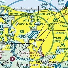
| Sectional chart |
|---|
|
CAUTION: Diagram may not be current
 Download PDF
of official airport diagram from the FAA
| Airport distance calculator |
|---|
|
|
| Sunrise and sunset |
|---|
|
Times for 28-Feb-2026
| | Local
(UTC-5) | | Zulu
(UTC) |
|---|
| Morning civil twilight | | 06:37 | | 11:37 |
| Sunrise | | 07:05 | | 12:05 |
| Sunset | | 18:15 | | 23:15 |
| Evening civil twilight | | 18:43 | | 23:43 |
|
| Current date and time |
|---|
| Zulu (UTC) | 28-Feb-2026 19:52:38 |
|---|
| Local (UTC-5) | 28-Feb-2026 14:52:38 |
|---|
|
| METAR |
|---|
| KCLE | 281851Z 01010KT 10SM BKN210 04/M04 A3009 RMK AO2 SLP210 T00391039 $
|
KBKL
11nm NE | 281853Z 02008KT 10SM CLR 02/M02 A3011 RMK AO2 SLP198 T00171017
|
KLPR
15nm W | 281853Z AUTO 06009KT 10SM CLR 04/M02 A3010 RMK AO2 SLP195 T00441022
|
KCGF
20nm NE | 281845Z 01009KT 10SM CLR 04/M03 A3009
|
|
| TAF |
|---|
| KCLE | 281740Z 2818/0124 02012KT P6SM BKN200 FM010300 03008KT P6SM -SN OVC035 FM010500 02010KT 6SM -SN OVC025 PROB30 0105/0109 4SM -SN OVC007 FM011100 02013KT P6SM OVC015 FM011600 36012G20KT P6SM BKN035
|
|
| NOTAMs |
|---|
NOTAMs are issued by the DoD/FAA and will open in a separate window not controlled by AirNav.
|
|


