FAA INFORMATION EFFECTIVE 17 APRIL 2025
Location
| FAA Identifier: | CPT |
| Lat/Long: | 32-21-13.5000N 097-26-01.5000W
32-21.225000N 097-26.025000W
32.3537500,-97.4337500
(estimated) |
| Elevation: | 854.2 ft. / 260.4 m (surveyed) |
| Variation: | 06E (2000) |
| From city: | 2 miles NW of CLEBURNE, TX |
| Time zone: | UTC -5 (UTC -6 during Standard Time) |
| Zip code: | 76031 |
Airport Operations
| Airport use: | Open to the public |
| Activation date: | 09/1960 |
| Control tower: | no |
| ARTCC: | FORT WORTH CENTER |
| FSS: | FORT WORTH FLIGHT SERVICE STATION |
| NOTAMs facility: | CPT (NOTAM-D service available) |
| Attendance: | MON-FRI 0800-1700, ALL SAT-SUN 0800-1600 |
| Wind indicator: | lighted |
| Segmented circle: | yes |
| Lights: | ACTVT PAPI RWY 15; MIRL RWY 15/33 - CTAF. |
| Beacon: | white-green (lighted land airport)
Operates sunset to sunrise. |
Airport Communications
| CTAF/UNICOM: | 122.8 |
| WX AWOS-3: | 119.525 (817-641-4135) |
| LONE STAR APPROACH: | 135.975 |
| LONE STAR DEPARTURE: | 135.975 |
| BOTCH DP: | 135.975 |
| DODJE STAR: | 125.2 125.9 |
| GARLAND DP: | 135.975 |
| LIKES STAR: | 125.8 ;SOUTH 135.975 ;NORTH |
| MOTZA STAR: | 118.1 ;SOUTH 125.8 ;NORTH |
| REEKO STAR: | 125.2 |
| SASIE STAR: | 124.3 |
| TRUUK RNAV STAR: | 124.3 |
| WESAT STAR: | 118.1 ;SOUTH 125.8 ;NORTH |
| WX AWOS-3PT at FWS (14 nm NE): | 120.025 (817-426-4172) |
Nearby radio navigation aids
| VOR radial/distance | | VOR name | | Freq | | Var |
|---|
| FUZr196/34.6 | | RANGER VORTAC | | 115.70 | | 06E |
| MQPr119/36.2 | | MILLSAP VORTAC | | 117.70 | | 09E |
| TTTr207/36.8 | | MAVERICK VOR/DME | | 113.10 | | 06E |
Airport Services
| Fuel available: | 100LL JET-A+
100LL:FUEL 24 HR SELF-SERVE. FOR ATTENDANT AFT HRS CALL 817-933-1650, CALL-IN FEE. |
| Parking: | hangars and tiedowns |
| Airframe service: | MAJOR
NO FABRIC OR COMPOSITE WORK. |
| Powerplant service: | MAJOR |
| Bottled oxygen: | HIGH/LOW |
| Bulk oxygen: | HIGH/LOW |
Runway Information
Runway 15/33
| Dimensions: | 5697 x 100 ft. / 1736 x 30 m |
| Surface: | asphalt, in fair condition |
| Weight bearing capacity: | |
| Runway edge lights: | medium intensity |
| RUNWAY 15 | | RUNWAY 33 |
| Latitude: | 32-21.664538N | | 32-20.786298N |
| Longitude: | 097-26.221302W | | 097-25.828330W |
| Elevation: | 853.7 ft. | | 844.9 ft. |
| Traffic pattern: | right | | left |
| Runway heading: | 153 magnetic, 159 true | | 333 magnetic, 339 true |
| Displaced threshold: | 185 ft. | | no |
| Markings: | nonprecision, in good condition | | nonprecision, in good condition |
| Visual slope indicator: | 4-light PAPI on left (3.00 degrees glide path) | | |
| Touchdown point: | yes, no lights | | yes, no lights |
| Instrument approach: | LOC/DME | | |
| Obstructions: | 25 ft. trees, 750 ft. from runway, 60 ft. right of centerline, 22:1 slope to clear
APCH SLOPE 37:1 TO DTHR. | | 32 ft. pole, 1340 ft. from runway, 285 ft. left of centerline, 35:1 slope to clear |
Airport Ownership and Management from official FAA records
| Ownership: | Publicly-owned |
| Owner: | CITY OF CLEBURNE
10 N ROBINSON, PO BOX 677
CLEBURNE, TX 76033
Phone 817-645-0900 |
| Manager: | TRISTEN RIGGINS
1650 AIRPORT DRIVE
CLEBURNE, TX 76033
Phone 817-641-5456
INTERIM AMGR. |
Additional Remarks
| - | FOR CD CTC REGIONAL APCH AT 972-615-2799. |
Instrument Procedures
NOTE: All procedures below are presented as PDF files. If you need a reader for these files, you should download the free Adobe Reader.NOT FOR NAVIGATION. Please procure official charts for flight.
FAA instrument procedures published for use from 17 April 2025 at 0901Z to 15 May 2025 at 0900z.
STARs - Standard Terminal Arrivals |
|---|
| MOTZA ONE | |
2 pages:
[1] [2] (426KB) |
| REEKO THREE (RNAV) | |
download (214KB) |
| SASIE SEVEN | |
2 pages:
[1] [2] (443KB) |
| SWVAY FOUR (RNAV) | |
download (239KB) |
| TRUUK TWO (RNAV) | |
download (219KB) |
| WESAT TWO (RNAV) | |
download (206KB) |
IAPs - Instrument Approach Procedures |
|---|
| RNAV (GPS) RWY 15 | |
download (215KB) |
| RNAV (GPS) RWY 33 | |
download (208KB) |
| LOC RWY 15 | |
download (218KB) |
| NOTE: Special Alternate Minimums apply | |
download (28KB) |
Departure Procedures |
|---|
| BOTCH ONE (RNAV) **NEW** | |
2 pages:
[1] [2] (352KB) |
| GARLAND SIX **NEW** | |
2 pages:
[1] [2] (312KB) |
| KINGDOM FIVE **NEW** | |
2 pages:
[1] [2] (337KB) |
| KUSSO ONE (RNAV) | |
2 pages:
[1] [2] (309KB) |
| NANDR THREE (RNAV) **NEW** | |
2 pages:
[1] [2] (312KB) |
| NOTE: Special Take-Off Minimums/Departure Procedures apply | |
download (117KB) |
Other nearby airports with instrument procedures:
KFWS - Fort Worth Spinks Airport (14 nm NE)
50F - Bourland Field Airport (16 nm NW)
KGDJ - Granbury Regional Airport (20 nm W)
KINJ - Hillsboro Municipal Airport (24 nm SE)
KNFW - Fort Worth Naval Air Station JRB (Carswell Field) Airport (25 nm N)
|
|

Road maps at:
MapQuest
Bing
Google
| Aerial photo |
|---|
WARNING: Photo may not be current or correct
 looking northwest
Do you have a better or more recent aerial photo of Cleburne Regional Airport that you would like to share? If so, please send us your photo.
|
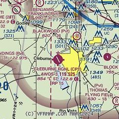
| Sectional chart |
|---|
|
CAUTION: Diagram may not be current

| Airport distance calculator |
|---|
|
|
| Sunrise and sunset |
|---|
|
Times for 08-May-2025
| | Local
(UTC-5) | | Zulu
(UTC) |
|---|
| Morning civil twilight | | 06:11 | | 11:11 |
| Sunrise | | 06:38 | | 11:38 |
| Sunset | | 20:15 | | 01:15 |
| Evening civil twilight | | 20:41 | | 01:41 |
|
| Current date and time |
|---|
| Zulu (UTC) | 08-May-2025 08:08:53 |
|---|
| Local (UTC-5) | 08-May-2025 03:08:53 |
|---|
|
| METAR |
|---|
| KCPT | 080755Z AUTO 00000KT 10SM CLR 17/17 A2998 RMK AO2 T01700168
|
KFWS
14nm NE | 080755Z AUTO 00000KT 7SM CLR 15/15 A3003 RMK AO2 T01530146 PWINO
|
|
| TAF |
|---|
KNFW
25nm N | 0723/0823 VRB06KT 9999 SCT032 QNH2991INS BECMG 0810/0812 VRB06KT 8000 BR SCT009 QNH3005INS TEMPO 0812/0814 BKN009 BECMG 0814/0816 34014G24KT 9999 SCT020 QNH3001INS TEMPO 0814/0818 BKN015 AUTOMATED SENSOR METWATCH 0804 TIL 0811 TX26/0723Z TN15/0812Z FN20070
|
KGKY
25nm NE | 080520Z 0806/0906 00000KT P6SM SKC TEMPO 0806/0808 2SM BR FM080800 33008KT P6SM SKC
|
KFTW
29nm N | 080520Z 0806/0906 VRB03KT P6SM SKC FM081000 33011KT P6SM FEW250
|
|
| NOTAMs |
|---|
NOTAMs are issued by the DoD/FAA and will open in a separate window not controlled by AirNav.
|
|


