FAA INFORMATION EFFECTIVE 02 OCTOBER 2025
Location
| FAA Identifier: | FLD |
| Lat/Long: | 43-46-16.2000N 088-29-18.3000W
43-46.270000N 088-29.305000W
43.7711667,-88.4884167
(estimated) |
| Elevation: | 808.4 ft. / 246.4 m (surveyed) |
| Variation: | 04W (2020) |
| From city: | 1 mile W of FOND DU LAC, WI |
| Time zone: | UTC -5 (UTC -6 during Standard Time) |
| Zip code: | 54937 |
Airport Operations
| Airport use: | Open to the public |
| Activation date: | 10/1958 |
| Control tower: | no |
| ARTCC: | CHICAGO CENTER |
| FSS: | GREEN BAY FLIGHT SERVICE STATION |
| NOTAMs facility: | FLD (NOTAM-D service available) |
| Attendance: | 0800-1800
FOR ATTENDANT AFT HRS CALL 920-922-6000. |
| Wind indicator: | lighted |
| Segmented circle: | yes |
| Lights: | HIRL RWY 18/36 PRESET TO LOW SS-SR; TO INCR INTST AND ACTVT MALSR RWY 36; REIL RWY 18; PAPI RWY 18 & 36; MIRL RWY 09/27 - CTAF. |
| Beacon: | white-green (lighted land airport)
Operates sunset to sunrise. |
Airport Communications
| CTAF/UNICOM: | 123.05 |
| WX ASOS: | 134.0 (920-922-4444) |
| MILWAUKEE APPROACH: | 127.0 |
| MILWAUKEE DEPARTURE: | 127.0 |
| WX ASOS at OSH (13 nm N): | PHONE 920-426-1644 |
Nearby radio navigation aids
| VOR radial/distance | | VOR name | | Freq | | Var |
|---|
| OSHr165/13.5 | | OSHKOSH VORTAC | | 116.75 | | 02E |
| BJBr324/(26.2) | | WEST BEND VOR | | 109.80 | | 01W |
| NDB name | | Hdg/Dist | | Freq | | Var | | ID |
|---|
| POBER | | 157/6.9 | | 395 | | 03W | | OS | --- ... |
| ROCK RIVER | | 017/37.3 | | 371 | | 01W | | RYV | .-. -.-- ...- |
Airport Services
| Fuel available: | 100LL JET-A |
| Parking: | hangars and tiedowns |
| Airframe service: | MAJOR |
| Powerplant service: | MAJOR |
| Bottled oxygen: | NONE |
| Bulk oxygen: | NONE |
Runway Information
Runway 18/36
| Dimensions: | 5941 x 100 ft. / 1811 x 30 m |
| Surface: | asphalt, in fair condition |
| Weight bearing capacity: | |
| Runway edge lights: | high intensity |
| RUNWAY 18 | | RUNWAY 36 |
| Latitude: | 43-46.748248N | | 43-45.770397N |
| Longitude: | 088-29.170675W | | 088-29.171905W |
| Elevation: | 782.6 ft. | | 794.2 ft. |
| Traffic pattern: | right | | left |
| Runway heading: | 184 magnetic, 180 true | | 004 magnetic, 000 true |
| Markings: | nonprecision, in fair condition | | nonprecision, in fair condition |
| Visual slope indicator: | 4-light PAPI on left (3.00 degrees glide path) | | 4-light PAPI on left (3.00 degrees glide path) |
| Approach lights: | | | MALSR: 1,400 foot medium intensity approach lighting system with runway alignment indicator lights |
| Runway end identifier lights: | yes | | |
| Touchdown point: | yes, no lights | | yes, no lights |
| Instrument approach: | | | LOC/DME |
| Obstructions: | 7 ft. bldg, 200 ft. from runway, 440 ft. left of centerline
7 FT BLDG 180 FT FM RWY END, 440 L. | | 17 ft. tree, 425 ft. from runway, 480 ft. left of centerline, 13:1 slope to clear |
Runway 9/27
| Dimensions: | 3602 x 75 ft. / 1098 x 23 m |
| Surface: | asphalt, in fair condition |
| Weight bearing capacity: | |
| Runway edge lights: | medium intensity |
| RUNWAY 9 | | RUNWAY 27 |
| Latitude: | 43-46.297390N | | 43-46.280103N |
| Longitude: | 088-29.936365W | | 088-29.118478W |
| Elevation: | 808.4 ft. | | 788.1 ft. |
| Traffic pattern: | right | | left |
| Runway heading: | 096 magnetic, 092 true | | 276 magnetic, 272 true |
| Markings: | nonprecision, in fair condition | | nonprecision, in fair condition |
| Runway end identifier lights: | no | | no |
| Touchdown point: | yes, no lights | | yes, no lights |
Airport Ownership and Management from official FAA records
| Ownership: | Publicly-owned |
| Owner: | FOND DU LAC COUNTY
160 S MACY
FOND DU LAC, WI 54935
Phone 920-922-4162 |
| Manager: | BRYAN LINGER
260 S. ROLLING MEADOWS DRIVE
FOND DU LAC, WI 54937
Phone 920-926-0653 |
Additional Remarks
| - | FOR CD IF UNA TO CTC ON FSS FREQ, CTC CHICAGO ARTCC AT 630-906-8921. |
Instrument Procedures
NOTE: All procedures below are presented as PDF files. If you need a reader for these files, you should download the free Adobe Reader.NOT FOR NAVIGATION. Please procure official charts for flight.
FAA instrument procedures published for use from 02 October 2025 at 0901Z to 30 October 2025 at 0900z.
IAPs - Instrument Approach Procedures |
|---|
| RNAV (GPS) RWY 18 | |
download (259KB) |
| RNAV (GPS) RWY 36 | |
download (281KB) |
| LOC RWY 36 | |
download (320KB) |
| VOR/DME RWY 36 | |
download (260KB) |
| VOR RWY 18 | |
download (236KB) |
| NOTE: Special Alternate Minimums apply | |
download (128KB) |
| NOTE: Special Take-Off Minimums/Departure Procedures apply | |
download (207KB) |
Other nearby airports with instrument procedures:
KOSH - Wittman Regional Airport (13 nm N)
8D1 - New Holstein Municipal Airport (19 nm NE)
KUNU - Dodge County Airport (23 nm SW)
KHXF - Hartford Municipal Airport (26 nm S)
KETB - West Bend Municipal Airport (26 nm SE)
|
|

Road maps at:
MapQuest
Bing
Google
| Aerial photo |
|---|
WARNING: Photo may not be current or correct

Do you have a better or more recent aerial photo of Fond Du Lac County Airport that you would like to share? If so, please send us your photo.
|
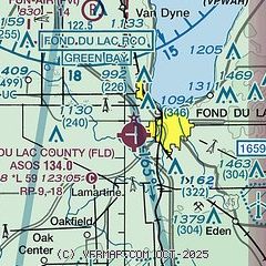
| Sectional chart |
|---|
|
CAUTION: Diagram may not be current

| Airport distance calculator |
|---|
|
|
| Sunrise and sunset |
|---|
|
Times for 19-Oct-2025
| | Local
(UTC-5) | | Zulu
(UTC) |
|---|
| Morning civil twilight | | 06:45 | | 11:45 |
| Sunrise | | 07:14 | | 12:14 |
| Sunset | | 18:04 | | 23:04 |
| Evening civil twilight | | 18:33 | | 23:33 |
|
| Current date and time |
|---|
| Zulu (UTC) | 19-Oct-2025 18:16:34 |
|---|
| Local (UTC-5) | 19-Oct-2025 13:16:34 |
|---|
|
| METAR |
|---|
| KFLD | 191753Z AUTO 31016G24KT 10SM CLR 13/03 A2967 RMK AO2 SLP047 60002 T01330028 10133 20083 50008 $
|
KOSH
12nm N | 191753Z 32016G25KT 10SM FEW047 13/02 A2964 RMK AO2 SLP035 60002 T01330022 10133 20083 50003
|
|
| NOTAMs |
|---|
NOTAMs are issued by the DoD/FAA and will open in a separate window not controlled by AirNav.
|
|


