FAA INFORMATION EFFECTIVE 25 DECEMBER 2025
Location
| FAA Identifier: | FQD |
| Lat/Long: | 35-25-41.6000N 081-56-06.2800W
35-25.693333N 081-56.104667W
35.4282222,-81.9350778
(estimated) |
| Elevation: | 1077.3 ft. / 328.4 m (surveyed) |
| Variation: | 05W (1995) |
| From city: | 3 miles N of RUTHERFORDTON, NC |
| Time zone: | UTC -5 (UTC -4 during Daylight Saving Time) |
| Zip code: | 28139 |
Airport Operations
| Airport use: | Open to the public |
| Activation date: | 11/1975 |
| Control tower: | no |
| ARTCC: | ATLANTA CENTER |
| FSS: | RALEIGH FLIGHT SERVICE STATION |
| NOTAMs facility: | FQD (NOTAM-D service available) |
| Attendance: | 0900-1800 |
| Wind indicator: | lighted |
| Segmented circle: | no |
| Lights: | ACTVT REIL RWY 01 & 19; PAPI RWY 01 & 19; MIRL RWY 01/19 - CTAF. |
| Beacon: | white-green (lighted land airport)
Operates sunset to sunrise. |
Airport Communications
| CTAF/UNICOM: | 122.8 |
| WX AWOS-3: | 118.275 (828-287-6498) |
| GREER APPROACH: | 119.4 |
| GREER DEPARTURE: | 119.4 |
| WX AWOS-3 at EHO (19 nm SE): | 118.425 (704-487-0100) |
- APCH/DEP SVC PRVDD BY ATLANTA ARTCC ON FREQS 132.625/353.625 (SUGARLOAF MOUNTAIN RCAG) WHEN APCH CTL CLSD.
Nearby radio navigation aids
| VOR radial/distance | | VOR name | | Freq | | Var |
|---|
| SUGr087/16.4 | | SUGARLOAF MOUNTAIN VORTAC | | 112.20 | | 02W |
| SPAr001/23.7 | | SPARTANBURG VORTAC | | 115.70 | | 02W |
| NDB name | | Hdg/Dist | | Freq | | Var | | ID |
|---|
| FIRST RIVER | | 309/19.5 | | 417 | | 06W | | SLP | ... .-.. .--. |
| FIDDLERS | | 224/21.3 | | 391 | | 07W | | FIQ | ..-. .. --.- |
| BROAD RIVER | | 077/27.8 | | 379 | | 07W | | BRA | -... .-. .- |
Airport Services
| Fuel available: | 100LL JET-A1+
100LL:100LL AND JET A 24 SELF SVC FUEL AVBL WITH CREDIT CARD. |
| Parking: | hangars and tiedowns |
| Airframe service: | MAJOR |
| Powerplant service: | MAJOR |
Runway Information
Runway 1/19
| Dimensions: | 5000 x 100 ft. / 1524 x 30 m |
| Surface: | asphalt, in excellent condition |
| Weight bearing capacity: | | Single wheel: | 50.0 | | Double wheel: | 75.0 |
|
| Runway edge lights: | medium intensity |
| RUNWAY 1 | | RUNWAY 19 |
| Latitude: | 35-25.283163N | | 35-26.105162N |
| Longitude: | 081-56.136182W | | 081-56.072835W |
| Elevation: | 1057.1 ft. | | 1077.3 ft. |
| Traffic pattern: | left | | left |
| Runway heading: | 009 magnetic, 004 true | | 189 magnetic, 184 true |
| Markings: | precision, in good condition | | nonprecision, in good condition |
| Visual slope indicator: | 2-light PAPI on left (3.00 degrees glide path) | | 2-light PAPI on left (3.25 degrees glide path) |
| Runway end identifier lights: | yes | | yes |
| Touchdown point: | yes, no lights | | yes, no lights |
| Instrument approach: | LOC/DME | | |
| Obstructions: | 27 ft. trees, 804 ft. from runway, 288 ft. left of centerline, 22:1 slope to clear | | 24 ft. trees, 327 ft. from runway, 254 ft. right of centerline, 5:1 slope to clear
6 FT FENCE 0-200 FT FM THR OFFSET 182 FT LEFT OF CNTRLN. |
Airport Ownership and Management from official FAA records
| Ownership: | Publicly-owned |
| Owner: | RUTHERFORD COUNTY ARPT AUTH
110 MARCHMAN FIELD DRIVE
RUTHERFORDTON, NC 28139
Phone 828-287-0800 |
| Manager: | DEVON RAISCH
110 MARCHMAN FIELD DRIVE, SUITE 102
RUTHERFORDTON, NC 28139
Phone (828) 287-0800
MGR MOBILE PH# 828-748-5480. |
Additional Remarks
| - | RWY 01 HAS 100 FT DROP-OFF 315 FT FM THR OFFSET 140 FT RIGHT AND 160 FT LEFT OF CNTRLN; AND 100 FT DROP-OFF 700-900 FT ALONG CNTRLN OFFSET 80 FT RIGHT. |
| - | DEER IN VICINITY OF ARPT. |
| - | FOR CD CTC GREER APCH AT 864-877-8275. WHEN GREER APCH CLSD, FOR CD CTC ATLANTA ARTCC AT 770-210-7692. |
| - | TWY A TOWARD RWY 1 HAS 30 FT DROP-OFF 60 FT RIGHT OF CNTRLN. |
| - | RWY 19 HAS 12 FT UNMARKED POWER LINES 440 FT FM THR BOTH SIDES OF CNTRLN. |
Instrument Procedures
NOTE: All procedures below are presented as PDF files. If you need a reader for these files, you should download the free Adobe Reader.NOT FOR NAVIGATION. Please procure official charts for flight.
FAA instrument procedures published for use from 25 December 2025 at 0901z to 22 January 2026 at 0900z.
IAPs - Instrument Approach Procedures |
|---|
| RNAV (GPS) RWY 01 | |
download (254KB) |
| RNAV (GPS) RWY 19 | |
download (250KB) |
| NOTE: Special Alternate Minimums apply | |
download (166KB) |
| NOTE: Special Take-Off Minimums/Departure Procedures apply | |
download (364KB) |
Other nearby airports with instrument procedures:
KEHO - Shelby-Cleveland County Regional Airport (19 nm SE)
KMRN - Foothills Regional Airport (28 nm NE)
KAVL - Asheville Regional Airport (30 nm W)
KSPA - Spartanburg Downtown Memorial Airport/Simpson Field (31 nm S)
KHKY - Hickory Regional Airport (33 nm NE)
|
|

Road maps at:
MapQuest
Bing
Google
| Aerial photo |
|---|
WARNING: Photo may not be current or correct
 Taken in November 2006
looking north
Taken in November 2006
looking north
Do you have a better or more recent aerial photo of Rutherford County Airport/Marchman Field that you would like to share? If so, please send us your photo.
|
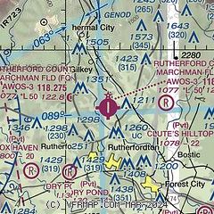
| Sectional chart |
|---|
|
| Airport distance calculator |
|---|
|
|
| Sunrise and sunset |
|---|
|
Times for 09-Jan-2026
| | Local
(UTC-5) | | Zulu
(UTC) |
|---|
| Morning civil twilight | | 07:10 | | 12:10 |
| Sunrise | | 07:38 | | 12:38 |
| Sunset | | 17:32 | | 22:32 |
| Evening civil twilight | | 17:59 | | 22:59 |
|
| Current date and time |
|---|
| Zulu (UTC) | 10-Jan-2026 04:29:23 |
|---|
| Local (UTC-5) | 09-Jan-2026 23:29:23 |
|---|
|
| METAR |
|---|
| KFQD | 100415Z AUTO 00000KT 1SM RA BKN003 OVC026 12/12 A3019 RMK AO2 P0005
|
KEHO
19nm SE | 100415Z AUTO 00000KT 1 1/4SM RA BKN005 BKN023 OVC029 14/13 A3019 RMK AO2 P0002 T01350130
|
|
| TAF |
|---|
KAVL
29nm W | 091950Z 0920/1018 19011KT P6SM SCT025 BKN050 TEMPO 0920/0924 5SM -SHRA BR BKN025 OVC050 FM100000 17003KT 5SM -SHRA BR OVC015 FM100600 36004KT 4SM -SHRA BR OVC007 PROB30 1009/1015 1SM SHRA BR OVC004 FM101500 18008G18KT 1SM -SHRA BR OVC005
|
KHKY
33nm NE | 092139Z 0922/1018 VRB03KT 1SM BR OVC002 TEMPO 0922/1002 1/4SM -RA FG VV002 FM100200 VRB03KT 5SM -SHRA BR OVC007 PROB30 1002/1007 1SM -SHRA BR OVC004 FM100700 VRB03KT 1SM -SHRA BR OVC003 FM101600 19008G18KT 2SM -SHRA BR OVC003
|
KGSP
35nm SW | 092205Z 0922/1018 16004KT 5SM -RA BR SCT008 OVC080 TEMPO 0923/1001 BKN008 OVC016 FM100100 VRB02KT 4SM -SHRA BR OVC007 FM100600 16006KT 3SM -SHRA BR OVC004 FM101400 20010G18KT 3SM -SHRA BR OVC004 PROB30 1014/1018 1SM -SHRA BR OVC002
|
|
| NOTAMs |
|---|
NOTAMs are issued by the DoD/FAA and will open in a separate window not controlled by AirNav.
|
|


