FAA INFORMATION EFFECTIVE 16 APRIL 2026
Location
| FAA Identifier: | GRF |
| Lat/Long: | 47-04-45.1900N 122-34-50.8200W
47-04.753167N 122-34.847000W
47.0792194,-122.5807833
(estimated) |
| Elevation: | 301 ft. / 91.7 m (surveyed) |
| Variation: | 16E (2015) |
| From city: | 1 mile E of central business district of the associated city |
| Time zone: | UTC -7 (UTC -8 during Standard Time) |
| Zip code: | 98433 |
Airport Operations
| Airport use: | Private use. Permission required prior to landing |
| Activation date: | 06/1943 |
| Control tower: | yes |
| ARTCC: | SEATTLE CENTER |
| FSS: | SEATTLE FLIGHT SERVICE STATION |
| NOTAMs facility: | GRF (NOTAM-D service available) |
| Attendance: | CONTINUOUS |
| Pattern altitude: | E/W TFC, F/W 1800 FT, R/W 800 FT. |
| Wind indicator: | yes |
| Segmented circle: | no |
| Beacon: | white-white-green (lighted military airport)
Operates sunset to sunrise. |
Airport Communications
| CTAF: | 119.325 |
| ATIS: | 124.65 306.2 |
| GRAY GROUND: | 121.9 290.2 [OPR H24 MON-FRI, CLSD WKENDS & HOLS.] |
| GRAY TOWER: | 119.325 256.8 41.5FM [OPR H24 MON-FRI, CLSD WKENDS & HOLS.] |
| SEATTLE APPROACH: | 120.1 |
| SEATTLE DEPARTURE: | 120.1 |
| CLEARANCE DELIVERY: | 121.9 290.2 |
| AR OPS: | 245.5 30.5 |
| ARNG OPS: | 32.6 |
| EMERG: | 121.5 243.0 |
| NG OPS: | 123.075 |
| OPS: | 138.6 395.225 41.5FM |
| PMSV METRO: | 134.1 38.45 |
| WX ASOS at TCM (6 nm NE): | PHONE 253-982-3434 |
| WX ASOS at TIW (11 nm N): | PHONE 253-858-6507 |
| WX AWOS-3 at PLU (12 nm E): | 128.575 (253-848-2748) |
| WX ASOS at OLM (15 nm SW): | PHONE 360-485-0905 |
- WX FLT DSN 357-7061/4363, C253-967-7061/4363. AN/FMQ-19 AUTOMATED OBS SYS IN USE, AUGMENTED BY HUMAN OBS WHEN NEC. DURG WX FLT CLOSURES REMOTE BRIEFING AVBL FM 25TH OWS DSN 228-6598/6599/6588, C520-228-6598/6599/6588.
Nearby radio navigation aids
| VOR radial/distance | | VOR name | | Freq | | Var |
|---|
| OLMr045/14.6 | | OLYMPIA VORTAC | | 113.40 | | 19E |
| SEAr188/24.1 | | SEATTLE VORTAC | | 116.80 | | 19E |
Airport Services
| Fuel available: | A++
A++:MIL; LTD SUPPLY; NATO F24 AVBL; TRANS ALERT 1400-2200++. |
Runway Information
Runway 15/33
| Dimensions: | 6124 x 150 ft. / 1867 x 46 m |
| Surface: | asphalt |
| Weight bearing capacity: | |
| Runway edge lights: | high intensity |
| RUNWAY 15 | | RUNWAY 33 |
| Latitude: | 47-05.243993N | | 47-04.262255N |
| Longitude: | 122-35.012147W | | 122-34.681930W |
| Elevation: | 289.2 ft. | | 300.4 ft. |
| Traffic pattern: | left | | left |
| Markings: | precision, in good condition | | precision, in good condition |
| Visual slope indicator: | 4-light PAPI on left (3.00 degrees glide path)
PAPI RWY 15 UNUSBL BYD 8 DEGS RIGHT OF CNTRLN. | | |
| RVR equipment: | touchdown | | rollout |
| Approach lights: | SSALR: simplified short approach lighting system with runway alignment indicator lights | | SSALR: simplified short approach lighting system with runway alignment indicator lights |
| Runway end identifier lights: | no | | no |
| Touchdown point: | yes, no lights | | yes, no lights |
| Instrument approach: | ILS/DME | | |
| Obstructions: | 114 ft. tower, lighted, 2613 ft. from runway | | none |
Helipad H2
| Dimensions: | 100 x 100 ft. / 30 x 30 m |
| Surface: | asphalt/concrete |
| Latitude: | 47-05.062167N | | |
| Longitude: | 122-35.039000W | | |
| Elevation: | 292.0 ft. | | |
| Traffic pattern: | left | | left |
Helipad H3
| Dimensions: | 100 x 100 ft. / 30 x 30 m |
| Surface: | asphalt/concrete |
| Latitude: | 47-04.950000N | | |
| Longitude: | 122-35.001167W | | |
| Elevation: | 294.0 ft. | | |
| Traffic pattern: | left | | left |
Helipad H4
| Dimensions: | 100 x 100 ft. / 30 x 30 m |
| Surface: | asphalt/concrete |
| Latitude: | 47-04.791667N | | |
| Longitude: | 122-34.935333W | | |
| Elevation: | 296.0 ft. | | |
| Traffic pattern: | left | | left |
Airport Ownership and Management from official FAA records
| Ownership: | U.S. Army |
| Owner: | US ARMY AERONAUTICAL SVCS AGENCY
FT BELVOIR, VA 22060
Phone 703 806 4864 |
| Manager: | NATHAN QUICK
Phone 253 967 6628
OTR CTC: 253-967-6676. |
Additional Remarks
| - | SEE FLIP AP/1 SUPPLEMENTARY ARPT RMK. |
| - | RSTD: 72 HR PPR TRAN ACFT. NO TRAN ACFT WKEND & HOL. |
| - | PJE INVOF ARPT. |
| - | MISC: SVFR DAY F/W 700-1, R/W 300- 1/2. NGT F/W NA, R/W 500-1. TACTICAL OPS ON JBLM MIL RSVN - CTC OPS PRIOR. CTC GRAY TFC ON CTAF WHEN TWR CLSD. CLASS D ASP WHEN ATCT OPEN; OTR TIMES CLASS E. TSNT HNGR NA. BASE OPS, TWR & WX MON-FRI H24; CLSD WKEND; CLSD HOL. |
| - | AR - CTC USAR OPS - D357-6628/C253-967-6628. |
| - | ARNG: OPR 1430-0100Z++ TUE-FRI EXC HOL. TRAN ALERT SVC NA. |
| - | CTN: NON RDO PAEW ON GND CTL XNG TWY G & H. |
| - | BULLSEYE RDO OPR MON-FRI H24; CLSD WKND CLSD HOL. R/W CTC BULLSEYE RDO PRIOR TO ENTRY R6703A-J - 34.6 141.5 379.1. RANGE STATUS - 384.525 & 142.7. |
| - | MISC: ADD RCR RPTD MON-FR 0700-1500 VIA NOTAM & ATIS DURG INCLEMENT WINTER WX. |
| - | NGT VISION TRNG ON ARPT; LGT MAY BE DIM OR OFF; R/W CTC GRAY ATCT ON INITIAL CTC IF UNAIDED. |
| - | MISC: BASE OPS, ATCT, & WX MON-FRI H24. CLSD WKEND; CLSD HOL. NO SPACE A PAX PPR WITHOUT PRIOR COORDINATION WITH AF MANAGER. |
| - | NO DE-ICE |
| - | FOR CD WHEN ATCT IS CLSD CTC SEATTLE APCH AT 206-214-4723. 120.1/290.9. |
| - | SMALL ARMS RANGE 0.8 NM E. |
Instrument Procedures
NOTE: All procedures below are presented as PDF files. If you need a reader for these files, you should download the free Adobe Reader.NOT FOR NAVIGATION. Please procure official charts for flight.
FAA instrument procedures published for use from 16 April 2026 at 0901Z to 14 May 2026 at 0900Z.
IAPs - Instrument Approach Procedures |
|---|
| ILS OR LOC RWY 15 | |
download (190KB) |
| RNAV (GPS) RWY 15 | |
download (100KB) |
| RNAV (GPS) RWY 33 | |
download (139KB) |
| NOTE: Special Alternate Minimums apply | |
download (211KB) |
Departure Procedures |
|---|
| LEWIS THREE | |
download (106KB) |
| NOTE: Special Take-Off Minimums/Departure Procedures apply | |
download (534KB) |
Other nearby airports with instrument procedures:
KTCM - McChord Field Airport (Joint Base Lewis-McChord) (6 nm NE)
KTIW - Tacoma Narrows Airport (11 nm N)
KPLU - Pierce County Airport/Thun Field (12 nm E)
KOLM - Olympia Regional Airport (15 nm SW)
S50 - Auburn Municipal Airport (21 nm NE)
|
|

Road maps at:
MapQuest
Bing
Google
| Aerial photo |
|---|
WARNING: Photo may not be current or correct
 Photo by Samuel M. Howard
Photo taken 16-Jun-2008
Photo by Samuel M. Howard
Photo taken 16-Jun-2008
Do you have a better or more recent aerial photo of Gray Army Airfield (Joint Base Lewis-McChord) that you would like to share? If so, please send us your photo.
|
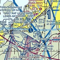
| Sectional chart |
|---|
|
 Download PDF
of official airport diagram from the FAA
| Airport distance calculator |
|---|
|
|
| Sunrise and sunset |
|---|
|
Times for 24-Apr-2026
| | Local
(UTC-7) | | Zulu
(UTC) |
|---|
| Morning civil twilight | | 05:34 | | 12:34 |
| Sunrise | | 06:07 | | 13:07 |
| Sunset | | 20:10 | | 03:10 |
| Evening civil twilight | | 20:43 | | 03:43 |
|
| Current date and time |
|---|
| Zulu (UTC) | 25-Apr-2026 05:14:54 |
|---|
| Local (UTC-7) | 24-Apr-2026 22:14:54 |
|---|
|
| METAR |
|---|
| KGRF | 250455Z AUTO 35004KT 10SM CLR 13/M05 A2995 RMK AO2 SLP146 T01251046 $
|
KTCM
5nm NE | 250455Z AUTO 00000KT 10SM CLR 08/M02 A2997 RMK AO2 SLP153 T00811020 $
|
KTIW
11nm N | 250453Z AUTO 04005KT 10SM CLR 13/M04 A2998 RMK AO2 SLP152 T01331039
|
KPLU
12nm E | 250455Z AUTO 00000KT 10SM CLR 08/02 A2999 RMK AO2
|
KOLM
15nm SW | 250454Z AUTO 00000KT 10SM CLR 08/M03 A2998 RMK AO2 SLP153 T00831028
|
|
| TAF |
|---|
| KGRF | 242100Z 2421/2603 31012G20KT 9999 FEW200 QNH3005INS BECMG 2502/2503 31012G23KT 9999 SKC QNH2997INS BECMG 2504/2505 01006KT 9999 SKC QNH2991INS TEMPO 2511/2515 8000 BR BECMG 2519/2520 34010KT 9999 FEW080 QNH2989INS TX18/2421Z TN04/2512Z
|
KTCM
5nm NE | 242100Z 2421/2603 02012G20KT 9999 FEW080 510005 QNH2996INS BECMG 2503/2504 02012KT 9999 FEW120 SCT200 QNH2991INS BECMG 2506/2507 VRB05KT 9999 FEW120 SCT200 QNH2994INS BECMG 2517/2518 01012KT 9999 FEW070 QNH2979INS TX18/2423Z TN03/2514Z
|
KOLM
15nm SW | 242058Z 2421/2518 06012G20KT P6SM SKC FM250300 04005KT P6SM SKC FM250600 00000KT P6SM FEW250 FM251000 00000KT 1SM BR VCFG BKN002 FM251600 04006KT P6SM SKC
|
|
| NOTAMs |
|---|
NOTAMs are issued by the DoD/FAA and will open in a separate window not controlled by AirNav.
|
|


