FAA INFORMATION EFFECTIVE 15 MAY 2025
Location
| FAA Identifier: | HXF |
| Lat/Long: | 43-21-00.1700N 088-23-24.8670W
43-21.002833N 088-23.414450W
43.3500472,-88.3902408
(estimated) |
| Elevation: | 1070 ft. / 326.1 m (surveyed) |
| Variation: | 03W (2010) |
| From city: | 2 miles NW of HARTFORD, WI |
| Time zone: | UTC -5 (UTC -6 during Standard Time) |
| Zip code: | 53027 |
Airport Operations
| Airport use: | Open to the public |
| Activation date: | 06/1978 |
| Control tower: | no |
| ARTCC: | CHICAGO CENTER |
| FSS: | GREEN BAY FLIGHT SERVICE STATION |
| NOTAMs facility: | GRB (NOTAM-D service available) |
| Attendance: | UNATNDD |
| Pattern altitude: | 1570 ft. MSL
TPA: 500 FT AGL ULTRALIGHTS. |
| Wind indicator: | lighted |
| Segmented circle: | yes |
| Lights: | ACTVT REIL RWY 9 & 27 - CTAF. MIRL RWY 09/27 PRESET TO LOW SS-SR, TO INCR INTST & ACTVT - CTAF. |
| Beacon: | white-green (lighted land airport)
Operates sunset to sunrise. |
Airport Communications
| CTAF/UNICOM: | 123.0 |
| MILWAUKEE APPROACH: | 125.35 [0530-2330] |
| MILWAUKEE DEPARTURE: | 125.35 [0530-2330] |
| GOPAC STAR: | 126.5 |
| WX AWOS-3 at ETB (12 nm E): | 120.0 (262-334-6161) |
| WX AWOS-3 at UNU (14 nm W): | 120.825 (920-386-5682) |
| WX AWOS-3 at RYV (18 nm SW): | 119.975 (920-261-0734) |
| WX AWOS-3 at UES (20 nm S): | 118.875 (262-521-5226) |
Nearby radio navigation aids
| VOR radial/distance | | VOR name | | Freq | | Var |
|---|
| BJBr251/(12.3) | | WEST BEND VOR | | 109.80 | | 01W |
| BAEr340/14.7 | | BADGER VOR/DME | | 116.40 | | 02E |
| OSHr167/39.1 | | OSHKOSH VORTAC | | 116.75 | | 02E |
| NDB name | | Hdg/Dist | | Freq | | Var | | ID |
|---|
| ROCK RIVER | | 055/18.1 | | 371 | | 01W | | RYV | .-. -.-- ...- |
Airport Services
| Fuel available: | 100LL JET-A+ MOGAS
100LL:24 HR FUEL AVBL WITH CREDIT CARD. |
| Parking: | hangars and tiedowns |
| Airframe service: | NONE |
| Powerplant service: | NONE |
| Bottled oxygen: | NONE |
| Bulk oxygen: | NONE |
Runway Information
Runway 9/27
| Dimensions: | 3401 x 75 ft. / 1037 x 23 m |
| Surface: | asphalt, in excellent condition |
| Weight bearing capacity: | |
| Runway edge lights: | medium intensity |
| RUNWAY 9 | | RUNWAY 27 |
| Latitude: | 43-21.040235N | | 43-21.029422N |
| Longitude: | 088-23.762017W | | 088-22.995170W |
| Elevation: | 1050.6 ft. | | 1070.0 ft. |
| Traffic pattern: | left | | left |
| Runway heading: | 094 magnetic, 091 true | | 274 magnetic, 271 true |
| Markings: | nonprecision, in good condition | | nonprecision, in good condition |
| Visual slope indicator: | 4-light PAPI on left (3.00 degrees glide path) | | 4-light PAPI on left (3.00 degrees glide path) |
| Runway end identifier lights: | yes | | yes |
| Touchdown point: | yes, no lights | | yes, no lights |
Runway 18/36
| Dimensions: | 2231 x 196 ft. / 680 x 60 m |
| Surface: | turf, in good condition |
| Runway edge markings: | MKD WITH ORANGE & WHITE WOODEN A-FRAMES. |
| RUNWAY 18 | | RUNWAY 36 |
| Latitude: | 43-21.136945N | | 43-20.771090N |
| Longitude: | 088-23.448360W | | 088-23.489863W |
| Elevation: | 1069.5 ft. | | 1035.8 ft. |
| Traffic pattern: | left | | left |
| Runway heading: | 188 magnetic, 185 true | | 008 magnetic, 005 true |
| Runway end identifier lights: | no | | no |
| Touchdown point: | yes, no lights | | yes, no lights |
Airport Ownership and Management from official FAA records
| Ownership: | Publicly-owned |
| Owner: | CITY OF HARTFORD
109 N. MAIN
HARTFORD, WI 53027
Phone 262-673-8263 |
| Manager: | DARRYL KRANZ
109 N MAIN
HARTFORD, WI 53027
Phone 262-673-8225
EMAIL ADDRESS: DKRANZ@HARTFORD.WI.GOV (ALL LOWER CASE). |
Additional Remarks
| A23 | RIGHT TFC PAT ULTRALIGHT & GLIDER ACFT. |
| A30A-18 | SLIGHT DOWNHILL SLOPE. |
| A30A-36 | +78 FT WATER TWR 3885 FT FM APCH END. |
| - | GLIDER & ULTRALIGHT ACTVTY ON ARPT. |
| - | FOR CD CTC CHICAGO ARTCC AT 630-906-8921. |
Instrument Procedures
NOTE: All procedures below are presented as PDF files. If you need a reader for these files, you should download the free Adobe Reader.NOT FOR NAVIGATION. Please procure official charts for flight.
FAA instrument procedures published for use from 15 May 2025 at 0901Z to 13 June 2025 at 0900z.
STARs - Standard Terminal Arrivals |
|---|
| GOPAC THREE (RNAV) | |
download (233KB) |
IAPs - Instrument Approach Procedures |
|---|
| RNAV (GPS) RWY 09 | |
download (192KB) |
| RNAV (GPS) RWY 27 | |
download (188KB) |
Departure Procedures |
|---|
| ACCRA FIVE (RNAV) | |
download (160KB) |
| UECKR SIX (RNAV) | |
download (177KB) |
| NOTE: Special Take-Off Minimums/Departure Procedures apply | |
download (599KB) |
Other nearby airports with instrument procedures:
KETB - West Bend Municipal Airport (12 nm E)
KUNU - Dodge County Airport (14 nm W)
KRYV - Watertown Municipal Airport (18 nm SW)
KUES - Waukesha County Airport (20 nm S)
KMWC - Lawrence J Timmerman Airport (21 nm SE)
|
|

Road maps at:
MapQuest
Bing
Google
| Aerial photo |
|---|
WARNING: Photo may not be current or correct
 Photo by Erica Larsen
Photo taken 29-Nov-2015
looking east.
Photo by Erica Larsen
Photo taken 29-Nov-2015
looking east.
Do you have a better or more recent aerial photo of Hartford Municipal Airport that you would like to share? If so, please send us your photo.
|
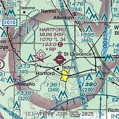
| Sectional chart |
|---|
|
| Airport distance calculator |
|---|
|
|
| Sunrise and sunset |
|---|
|
Times for 02-Jun-2025
| | Local
(UTC-5) | | Zulu
(UTC) |
|---|
| Morning civil twilight | | 04:42 | | 09:42 |
| Sunrise | | 05:16 | | 10:16 |
| Sunset | | 20:27 | | 01:27 |
| Evening civil twilight | | 21:01 | | 02:01 |
|
| Current date and time |
|---|
| Zulu (UTC) | 02-Jun-2025 20:47:03 |
|---|
| Local (UTC-5) | 02-Jun-2025 15:47:03 |
|---|
|
| METAR |
|---|
KETB
12nm E | 022035Z AUTO 22010KT 10SM CLR 27/08 A2990 RMK AO2
|
KUNU
14nm W | 022010Z AUTO 19014G21KT 10SM CLR 26/08 A2991 RMK AO2 T02600083 TSNO
|
KRYV
18nm SW | 022035Z AUTO 21011G16KT 10SM CLR 27/08 A2989 RMK AO2 T02710079
|
KMWC
22nm SE | 021955Z 19009KT 10SM CLR 26/08 A2993
|
KUES
23nm SE | 021945Z 20008G18KT 10SM CLR 27/ A2994
|
|
| TAF |
|---|
KUES
23nm SE | 021720Z 0218/0318 21010KT P6SM BKN250 FM030100 18007KT P6SM SCT250 FM030700 19009KT P6SM SCT250 WS020/21045KT FM031200 21012G20KT P6SM SCT250 FM031500 20015G25KT P6SM SCT250
|
|
| NOTAMs |
|---|
NOTAMs are issued by the DoD/FAA and will open in a separate window not controlled by AirNav.
|
|


