FAA INFORMATION EFFECTIVE 14 MAY 2026
Location
| FAA Identifier: | UES |
| Lat/Long: | 43-02-27.7000N 088-14-13.4000W
43-02.461667N 088-14.223333W
43.0410278,-88.2370556
(estimated) |
| Elevation: | 911.5 ft. / 277.8 m (surveyed) |
| Variation: | 01W (1990) |
| From city: | 2 miles N of WAUKESHA, WI |
| Time zone: | UTC -5 (UTC -6 during Standard Time) |
| Zip code: | 53188 |
Airport Operations
| Airport use: | Open to the public |
| Activation date: | 09/1937 |
| Control tower: | yes |
| ARTCC: | CHICAGO CENTER |
| FSS: | GREEN BAY FLIGHT SERVICE STATION |
| NOTAMs facility: | UES (NOTAM-D service available) |
| Attendance: | CONTINUOUS |
| Wind indicator: | lighted |
| Segmented circle: | yes |
| Lights: | HIRL RWY 10/28 PRESET ON LOW INTST; TO INCR INTST & ACTVT MALSR RWY 10; REIL RWY 28, MIRL RWY 18/36 - CTAF. PAPI RWY 10 & VASI RWY 28 OPR CONSLY. |
| Beacon: | white-green (lighted land airport)
Operates sunset to sunrise. |
Airport Communications
| CTAF: | 123.7 |
| UNICOM: | 122.95 |
| ATIS: | 118.875 |
| WX AWOS-3: | 118.875 (262-521-5226) |
| WAUKESHA GROUND: | 121.6 [0600-2100] |
| WAUKESHA TOWER: | 123.7 [0600-2100] |
| MILWAUKEE APPROACH: | 125.35 |
| MILWAUKEE DEPARTURE: | 125.35 |
| CLEARANCE DELIVERY: | 128.7 ;WHEN TWR CLSD 121.6 |
| AR OPS: | 38.3 |
| GOPAC STAR: | 126.5 |
| WX AWOS-3 at MWC (10 nm NE): | PHONE 414-461-2954 |
| WX AWOS-3PT at 57C (16 nm S): | 118.125 (262-642-1845) |
| WX ASOS at MKE (16 nm E): | 126.4 (414-400-9402) |
Nearby radio navigation aids
| VOR radial/distance | | VOR name | | Freq | | Var |
|---|
| BAEr154/5.0 | | BADGER VOR/DME | | 116.40 | | 02E |
| BJBr193/(23.4) | | WEST BEND VOR | | 109.80 | | 01W |
| NDB name | | Hdg/Dist | | Freq | | Var | | ID |
|---|
| ROCK RIVER | | 111/22.8 | | 371 | | 01W | | RYV | .-. -.-- ...- |
Airport Services
| Fuel available: | 100LL JET-A+ |
| Parking: | hangars and tiedowns |
| Airframe service: | MAJOR |
| Powerplant service: | MAJOR |
| Bottled oxygen: | HIGH |
| Bulk oxygen: | HIGH
CALL 262-549-6150 FOR OXY AVBLY. |
Runway Information
Runway 10/28
| Dimensions: | 5849 x 100 ft. / 1783 x 30 m |
| Surface: | concrete/grooved, in excellent condition |
| Weight bearing capacity: | | Single wheel: | 60.0 | | Double wheel: | 100.0, GROSS WT 2S-155 |
|
| Runway edge lights: | high intensity |
| RUNWAY 10 | | RUNWAY 28 |
| Latitude: | 43-02.636745N | | 43-02.437200N |
| Longitude: | 088-14.982922W | | 088-13.698818W |
| Elevation: | 897.2 ft. | | 906.1 ft. |
| Traffic pattern: | left | | right |
| Runway heading: | 103 magnetic, 102 true | | 283 magnetic, 282 true |
| Markings: | precision, in good condition | | precision, in good condition |
| Visual slope indicator: | 4-light PAPI on right (3.00 degrees glide path) | | 4-box VASI on left (3.75 degrees glide path) |
| Approach lights: | MALSR: 1,400 foot medium intensity approach lighting system with runway alignment indicator lights | | |
| Runway end identifier lights: | no | | yes |
| Touchdown point: | yes, no lights | | yes, no lights |
| Instrument approach: | ILS | | |
| Obstructions: | none | | 75 ft. trees, 1600 ft. from runway, 100 ft. left of centerline, 18:1 slope to clear |
Runway 18/36
| Dimensions: | 3599 x 75 ft. / 1097 x 23 m |
| Surface: | asphalt, in fair condition |
| Weight bearing capacity: | |
| Runway edge lights: | medium intensity |
| RUNWAY 18 | | RUNWAY 36 |
| Latitude: | 43-02.633527N | | 43-02.043518N |
| Longitude: | 088-13.993392W | | 088-14.067088W |
| Elevation: | 906.3 ft. | | 911.5 ft. |
| Traffic pattern: | left | | right |
| Runway heading: | 186 magnetic, 185 true | | 006 magnetic, 005 true |
| Markings: | nonprecision, in fair condition | | nonprecision, in fair condition |
| Visual slope indicator: | 2-light PAPI on left (3.00 degrees glide path) | | 2-light PAPI on left (4.00 degrees glide path) |
| Runway end identifier lights: | yes | | yes |
| Touchdown point: | yes, no lights | | yes, no lights |
| Obstructions: | none | | 50 ft. tree, 1140 ft. from runway, 25 ft. right of centerline, 18:1 slope to clear |
Airport Ownership and Management from official FAA records
| Ownership: | Publicly-owned |
| Owner: | WAUKESHA COUNTY
515 W MOORLAND BLVD
WAUKESHA, WI 53188
Phone 262-548-7010 |
| Manager: | KURT STANICH
2525 AVIATION DR
WAUKESHA, WI 53188
Phone 262-521-5250
CELL PHONE: 262-424-6747 |
Additional Remarks
| - | COYOTES ON & INVOF ARPT. |
| - | NORTH RAMP LIGHTS OUT OF SERVICE |
| - | CALL MILWAUKEE (MKE) CLEARENCE DELIVERY 128.7 'ONLY' WHEN WAUKESHA (UES) TWR CLSD. |
Instrument Procedures
NOTE: All procedures below are presented as PDF files. If you need a reader for these files, you should download the free Adobe Reader.NOT FOR NAVIGATION. Please procure official charts for flight.
FAA instrument procedures published for use from 14 May 2026 at 0901Z to 11 June 2026 at 0900Z.
STARs - Standard Terminal Arrivals |
|---|
| GOPAC THREE (RNAV) | |
download (234KB) |
IAPs - Instrument Approach Procedures |
|---|
| ILS OR LOC RWY 10 | |
download (271KB) |
| RNAV (GPS) RWY 10 | |
download (282KB) |
| RNAV (GPS) RWY 28 | |
download (243KB) |
| VOR-A | |
download (204KB) |
| NOTE: Special Alternate Minimums apply | |
download (162KB) |
Departure Procedures |
|---|
| ACCRA FIVE (RNAV) | |
download (176KB) |
| UECKR SIX (RNAV) | |
download (193KB) |
| NOTE: Special Take-Off Minimums/Departure Procedures apply | |
download (201KB) |
Other nearby airports with instrument procedures:
KMWC - Lawrence J Timmerman Airport (10 nm NE)
57C - East Troy Municipal Airport (16 nm S)
KMKE - General Mitchell International Airport (16 nm E)
KHXF - Hartford Municipal Airport (20 nm N)
KBUU - Burlington Municipal Airport (21 nm S)
|
|

Road maps at:
MapQuest
Bing
Google
| Aerial photo |
|---|
WARNING: Photo may not be current or correct
 Photo by Josh Haberstroh
Photo taken 21-Mar-2016
looking northwest.
Photo by Josh Haberstroh
Photo taken 21-Mar-2016
looking northwest.
Do you have a better or more recent aerial photo of Waukesha County Airport that you would like to share? If so, please send us your photo.
|
| Sectional chart |
|---|
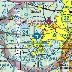
|
CAUTION: Diagram may not be current
 Download PDF
of official airport diagram from the FAA
| Airport distance calculator |
|---|
|
|
| Sunrise and sunset |
|---|
|
Times for 17-May-2026
| | Local
(UTC-5) | | Zulu
(UTC) |
|---|
| Morning civil twilight | | 04:56 | | 09:56 |
| Sunrise | | 05:29 | | 10:29 |
| Sunset | | 20:10 | | 01:10 |
| Evening civil twilight | | 20:43 | | 01:43 |
|
| Current date and time |
|---|
| Zulu (UTC) | 17-May-2026 16:33:00 |
|---|
| Local (UTC-5) | 17-May-2026 11:33:00 |
|---|
|
| METAR |
|---|
KUES
5nm E | 171545Z 06005KT 10SM BKN017 13/08 A2994
|
KMWC
11nm NE | 171615Z AUTO 05006KT 10SM SCT018 SCT120 11/06 A2995 RMK AO2
|
KMKE
16nm E | 171552Z 01009KT 10SM FEW080 BKN130 OVC250 09/05 A2994 RMK AO2 PRESRR SLP137 T00890050 $
|
K57C
16nm S | 171615Z AUTO 09006KT 10SM CLR A2988 RMK AO2 LTG DSNT W
|
|
| TAF |
|---|
KUES
5nm E | 171143Z 1712/1812 06006KT P6SM BKN080 TEMPO 1714/1717 4SM -SHRA OVC025 FM171700 09008KT P6SM BKN035 PROB30 1717/1718 4SM -SHRA OVC025 FM171800 10008KT P6SM BKN026 PROB30 1718/1721 4SM -TSRA OVC015CB FM172100 10008KT P6SM BKN060 WS020/18030KT FM180800 20010G22KT P6SM SCT210 WS020/22045KT
|
KMKE
16nm E | 171143Z 1712/1818 02008KT P6SM BKN140 TEMPO 1714/1717 4SM -SHRA OVC025 FM171900 08009KT P6SM BKN027 FM172200 08008KT P6SM BKN070 FM180300 17008KT P6SM BKN029 FM180600 18009KT P6SM SCT080 WS020/21040KT FM181500 21013G23KT P6SM -SHRA BKN050 PROB30 1815/1818 4SM TSRA OVC025CB
|
|
| NOTAMs |
|---|
NOTAMs are issued by the DoD/FAA and will open in a separate window not controlled by AirNav.
|
|


