FAA INFORMATION EFFECTIVE 14 MAY 2026
Location
| FAA Identifier: | JST |
| Lat/Long: | 40-18-56.0000N 078-50-04.8000W
40-18.933333N 078-50.080000W
40.3155556,-78.8346667
(estimated) |
| Elevation: | 2284.2 ft. / 696.2 m (surveyed) |
| Variation: | 10W (2010) |
| From city: | 3 miles NE of JOHNSTOWN, PA |
| Time zone: | UTC -4 (UTC -5 during Standard Time) |
| Zip code: | 15904 |
Airport Operations
| Airport use: | Open to the public |
| Activation date: | 06/1948 |
| Control tower: | yes |
| ARTCC: | CLEVELAND CENTER |
| FSS: | ALTOONA FLIGHT SERVICE STATION |
| NOTAMs facility: | JST (NOTAM-D service available) |
| Attendance: | 0700-2300 |
| Wind indicator: | lighted |
| Segmented circle: | no |
| Lights: | WHEN TWR CLSD ACTVT MALSR RWY 33; PAPI RWY 33; HIRL RWY 15/33, MIRL RWY 5/23 AND ALL TWY LGTS - CTAF. PAPI RWY 05 UNAVBL WHEN ATCT CLSD. |
| Beacon: | white-green (lighted land airport)
Operates sunset to sunrise. |
| Landing fee: | yes |
| Fire and rescue: | ARFF index A |
| Airline operations: | 48 HR PPR FOR UNSKED ACR OPS WITH MORE THAN 30 PAX SEATS; CALL AMGR 814-536-0002. |
Airport Communications
| CTAF: | 125.75 |
| UNICOM: | 122.95 |
| ATIS: | 118.325 |
| WX ASOS: | PHONE 814-535-3511 |
| JOHNSTOWN GROUND: | 121.6 [0700-2300] |
| JOHNSTOWN TOWER: | 125.75 [0700-2300] |
| JOHNSTOWN APPROACH: | 121.2 299.2 [0700-2300] |
| JOHNSTOWN DEPARTURE: | 121.2 299.2 [0700-2300] |
| CLEARANCE DELIVERY: | 126.85 235.775 |
| ARNG OPS: | 241.35 ;KEYSTONE OPS 46.75FM ;KEYSTONE OPS |
| OPS: | 138.55 ;ARNG KEYSTONE |
| WX AWOS-3P at 2G9 (19 nm SW): | 133.8 (814-443-2114) |
- UNICOM FREQ 122.950 AVBL FOR GND SVCS ONLY.
- APCH/DEP SVC PRVDD BY CLEVELAND ARTCC (ZOB) ON FREQS 124.4/327.1 (ALTOONA RCAG ) WHEN JOHNSTOWN APCH CTL CLSD.
Nearby radio navigation aids
| VOR radial/distance | | VOR name | | Freq | | Var |
|---|
| JST at field | | JOHNSTOWN VOR/DME | | 113.00 | | 06W |
Airport Services
| Fuel available: | 100LL JET-A JET-A+ |
| Parking: | hangars and tiedowns |
| Airframe service: | MAJOR |
| Powerplant service: | MAJOR |
Runway Information
Runway 15/33
| Dimensions: | 7004 x 150 ft. / 2135 x 46 m |
| Surface: | concrete/grooved, in good condition |
| Weight bearing capacity: | | Single wheel: | 93.0 | | Double wheel: | 183.0 | | Double tandem: | 357.0 | | Dual double tandem: | 845.0 |
|
| Runway edge lights: | high intensity |
| RUNWAY 15 | | RUNWAY 33 |
| Latitude: | 40-19.419533N | | 40-18.484748N |
| Longitude: | 078-50.532342W | | 078-49.649602W |
| Elevation: | 2270.2 ft. | | 2259.9 ft. |
| Traffic pattern: | left | | left |
| Runway heading: | 154 magnetic, 144 true | | 334 magnetic, 324 true |
| Declared distances: | TORA:7004 TODA:7004 ASDA:6698 LDA:6698 | | TORA:7004 TODA:7004 ASDA:6484 LDA:6484 |
| Markings: | precision, in good condition | | precision, in good condition |
| Visual slope indicator: | 4-box VASI on left (3.00 degrees glide path) | | 4-light PAPI on right (3.00 degrees glide path) |
| Approach lights: | | | MALSR: 1,400 foot medium intensity approach lighting system with runway alignment indicator lights |
| Touchdown point: | yes, no lights | | yes, no lights |
| Instrument approach: | | | ILS |
| Obstructions: | 36 ft. trees, 480 ft. from runway, 394 ft. left of centerline, 7:1 slope to clear | | 17 ft. trees, 928 ft. from runway, 436 ft. right of centerline, 42:1 slope to clear |
Runway 5/23
| Dimensions: | 4387 x 100 ft. / 1337 x 30 m |
| Surface: | asphalt/grooved, in good condition |
| Weight bearing capacity: | | Single wheel: | 62.0, 2S-110. | | Double wheel: | 87.0 |
|
| Runway edge lights: | medium intensity |
| RUNWAY 5 | | RUNWAY 23 |
| Latitude: | 40-18.623790N | | 40-19.182483N |
| Longitude: | 078-50.360610W | | 078-49.762200W |
| Elevation: | 2270.4 ft. | | 2279.5 ft. |
| Traffic pattern: | left | | left |
| Runway heading: | 049 magnetic, 039 true | | 229 magnetic, 219 true |
| Declared distances: | TORA:4387 TODA:4387 ASDA:4387 LDA:4387 | | TORA:4387 TODA:4387 ASDA:4387 LDA:4387 |
| Markings: | nonprecision, in good condition | | nonprecision, in good condition |
| Visual slope indicator: | 4-light PAPI on left (3.00 degrees glide path) | | 4-box VASI on left (3.00 degrees glide path) |
| Runway end identifier lights: | yes | | yes |
| Touchdown point: | yes, no lights | | yes, no lights |
| Obstructions: | 26 ft. trees, 261 ft. from runway, 402 ft. left of centerline, 2:1 slope to clear | | 46 ft. bldg, 746 ft. from runway, 576 ft. right of centerline, 11:1 slope to clear |
Airport Ownership and Management from official FAA records
| Ownership: | Publicly-owned |
| Owner: | JOHNSTOWN-CAMBRIA CO APT AUTH
479 ARPT ROAD
JOHNSTOWN, PA 15904
Phone 814-536-0002 |
| Manager: | CORY CREE
479 ARPT ROAD
JOHNSTOWN, PA 15904
Phone 814-536-0002 |
Additional Remarks
| A39-05/23 | PCR VALUE: 240/F/D/X/T |
| A39-15/33 | PCR VALUE: 630/R/B/W/T |
| - | TWY B BTN RWY 05/23 AND TWY B2 RSTRD TO ACFT WITH WINGSPAN 78 FT OR LESS. |
| - | ARNG: RSTD PPR 24 HR, CALL DUR NML DUTY HOURS 1300-2130Z++ EXC WKEND AND HOL. CTC OPS C814-532-7720. ALL TFC TO ARNG MILITARY RAMP CTC KEYSTONE OPS: 138.55, 241.35, 46.75, RAMP DECONFLICTION 46.75. |
| - | DEER & BIRDS ON & INVOF ARPT. |
| - | FOR CD CTC JOHNSTOWN APCH AT 814-532-5960, WHEN APCH CLSD CTC CLEVELAND ARTCC AT 440-774-0213. |
Instrument Procedures
NOTE: All procedures below are presented as PDF files. If you need a reader for these files, you should download the free Adobe Reader.NOT FOR NAVIGATION. Please procure official charts for flight.
FAA instrument procedures published for use from 14 May 2026 at 0901Z to 11 June 2026 at 0900Z.
IAPs - Instrument Approach Procedures |
|---|
| ILS OR LOC RWY 33 | |
download (221KB) |
| RNAV (GPS) RWY 05 | |
download (228KB) |
| RNAV (GPS) RWY 15 | |
download (209KB) |
| RNAV (GPS) RWY 23 | |
download (231KB) |
| RNAV (GPS) RWY 33 | |
download (252KB) |
| VOR Z RWY 15 | |
download (207KB) |
| VOR RWY 05 | |
download (168KB) |
| VOR Y RWY 15 | |
download (157KB) |
| VOR Y RWY 23 | |
download (194KB) |
| VOR Z RWY 23 | |
download (210KB) |
| NOTE: Special Alternate Minimums apply | |
download (145KB) |
Departure Procedures |
|---|
| JENER FOUR | |
download (149KB) |
| LILLI FIVE | |
download (173KB) |
| NOTE: Special Take-Off Minimums/Departure Procedures apply | |
download (427KB) |
Other nearby airports with instrument procedures:
9G8 - Ebensburg Airport (9 nm N)
2G9 - Somerset County Airport (19 nm SW)
KHMZ - Bedford County Airport (20 nm SE)
KIDI - Indiana County Airport (Jimmy Stewart Field) (23 nm NW)
KAOO - Altoona/Blair County Airport (24 nm E)
|
|

Road maps at:
MapQuest
Bing
Google
| Aerial photo |
|---|
WARNING: Photo may not be current or correct
 Photo by Walter Mong
Taken in October 2012
looking west.
Photo by Walter Mong
Taken in October 2012
looking west.
Do you have a better or more recent aerial photo of John Murtha Johnstown/Cambria County Airport that you would like to share? If so, please send us your photo.
|
| Sectional chart |
|---|
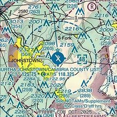
|
CAUTION: Diagram may not be current
 Download PDF
of official airport diagram from the FAA
| Airport distance calculator |
|---|
|
|
| Sunrise and sunset |
|---|
|
Times for 01-Jun-2026
| | Local
(UTC-4) | | Zulu
(UTC) |
|---|
| Morning civil twilight | | 05:16 | | 09:16 |
| Sunrise | | 05:49 | | 09:49 |
| Sunset | | 20:38 | | 00:38 |
| Evening civil twilight | | 21:10 | | 01:10 |
|
| Current date and time |
|---|
| Zulu (UTC) | 01-Jun-2026 11:27:56 |
|---|
| Local (UTC-4) | 01-Jun-2026 07:27:56 |
|---|
|
| METAR |
|---|
| KJST | 011054Z AUTO 31003KT 10SM CLR 11/04 A3000 RMK AO2 SLP155 T01060044
|
K2G9
19nm SW | 011115Z AUTO 00000KT 10SM CLR 08/06 A3002 RMK AO2
|
|
| TAF |
|---|
| KJST | 010531Z 0106/0206 32003KT P6SM SCT250 FM011200 36005KT P6SM BKN250 FM011600 35008KT P6SM BKN070 BKN250 FM012300 08005KT P6SM SCT060
|
|
| NOTAMs |
|---|
NOTAMs are issued by the DoD/FAA and will open in a separate window not controlled by AirNav.
|
|


