FAA INFORMATION EFFECTIVE 14 MAY 2026
Location
| FAA Identifier: | OZW |
| Lat/Long: | 42-37-45.9400N 083-58-55.8950W
42-37.765667N 083-58.931583W
42.6294278,-83.9821931
(estimated) |
| Elevation: | 962 ft. / 293.2 m (surveyed) |
| Variation: | 05W (1990) |
| From city: | 3 miles NW of HOWELL, MI |
| Time zone: | UTC -4 (UTC -5 during Standard Time) |
| Zip code: | 48843 |
Airport Operations
| Airport use: | Open to the public |
| Activation date: | 11/1950 |
| Control tower: | no |
| ARTCC: | CLEVELAND CENTER |
| FSS: | LANSING FLIGHT SERVICE STATION |
| NOTAMs facility: | OZW (NOTAM-D service available) |
| Attendance: | MON-FRI 0700-1700, ALL SAT-SUN 0800-1200 |
| Pattern altitude: | 2001 ft. MSL |
| Wind indicator: | lighted |
| Segmented circle: | yes |
| Lights: | ACTVT OR INCR INTST MALSR RWY 13; REIL RWY 31; HIRL RWY 13/31 - CTAF. PAPI RWY 13 & 31 OPR CONSLY DAWN-DUSK; HIRL RWY 13/31 PRESET LOW INTST DUSK-2200. |
| Beacon: | white-green (lighted land airport)
Operates sunset to sunrise. |
Airport Communications
| CTAF/UNICOM: | 123.0 |
| WX AWOS-3P: | 118.875 (517-546-4450) |
| DETROIT APPROACH: | 132.35 |
| DETROIT DEPARTURE: | 132.35 |
| CLEARANCE DELIVERY: | 121.725 |
| WX AWOS-3P at TEW (20 nm W): | 119.425 (517-676-5607) |
- FOR CD KEY FREQ 121.725 4 TIMES. TO CONTACT FSS KEY FREQ 121.725 6 TIMES; ONE SECOND ON/ONE SECOND OFF; MONITOR 121.725 WHILE ELECTRONIC EQUIP DIALS DET CD/LANSING FSS.
Nearby radio navigation aids
| VOR radial/distance | | VOR name | | Freq | | Var |
|---|
| SVMr311/21.7 | | SALEM VORTAC | | 114.30 | | 03W |
| FNTr213/22.7 | | FLINT VORTAC | | 116.90 | | 06W |
| DXOr318/37.0 | | DETROIT VOR/DME | | 113.40 | | 06W |
Airport Services
| Fuel available: | 100LL JET-A JET-A+ |
| Parking: | hangars and tiedowns |
| Airframe service: | MAJOR |
| Powerplant service: | MAJOR |
Runway Information
Runway 13/31
| Dimensions: | 5002 x 100 ft. / 1525 x 30 m |
| Surface: | concrete/grooved, in good condition |
| Weight bearing capacity: | |
| Runway edge lights: | high intensity |
| RUNWAY 13 | | RUNWAY 31 |
| Latitude: | 42-38.015500N | | 42-37.515833N |
| Longitude: | 083-59.374833W | | 083-58.488333W |
| Elevation: | 962.0 ft. | | 943.2 ft. |
| Traffic pattern: | left | | left |
| Runway heading: | 132 magnetic, 127 true | | 312 magnetic, 307 true |
| Markings: | precision, in good condition | | precision, in good condition |
| Visual slope indicator: | 4-light PAPI on left (3.00 degrees glide path) | | 4-light PAPI on left (3.00 degrees glide path) |
| Approach lights: | MALSR: 1,400 foot medium intensity approach lighting system with runway alignment indicator lights | | |
| Runway end identifier lights: | no | | yes |
| Touchdown point: | yes, no lights | | yes, no lights |
| Instrument approach: | ILS/DME | | |
| Obstructions: | 58 ft. tree, 1313 ft. from runway, 650 ft. right of centerline, 19:1 slope to clear | | 40 ft. tree, 471 ft. from runway, 550 ft. right of centerline, 6:1 slope to clear |
Airport Ownership and Management from official FAA records
| Ownership: | Publicly-owned |
| Owner: | LIVINGSTON COUNTY
3399 COUNTY AIRPORT DR
HOWELL, MI 48855
Phone 517-546-3520 |
| Manager: | MARK D JOHNSON
3399 COUNTY AIRPORT DR
HOWELL, MI 48855
Phone 517-546-6675 |
Additional Remarks
| - | DEER & LRG BIRDS ON & INVOF ARPT. |
| - | GCO AVBL ON FREQ 121.725 THRU DTW CLNC DEL & FLT SVCS. |
| - | FOR CD CTC DETROIT APCH AT 734-955-1404. |
Instrument Procedures
NOTE: All procedures below are presented as PDF files. If you need a reader for these files, you should download the free Adobe Reader.NOT FOR NAVIGATION. Please procure official charts for flight.
FAA instrument procedures published for use from 14 May 2026 at 0901Z to 11 June 2026 at 0900Z.
STARs - Standard Terminal Arrivals |
|---|
| FOREY TWO (RNAV) | |
download (160KB) |
| OKLND ONE (RNAV) | |
download (145KB) |
| PETTE TWO (RNAV) | |
download (210KB) |
| RRALF THREE (RNAV) | |
download (162KB) |
IAPs - Instrument Approach Procedures |
|---|
| ILS OR LOC RWY 13 **CHANGED** | |
download (286KB) |
| RNAV (GPS) RWY 13 **CHANGED** | |
download (218KB) |
| RNAV (GPS) RWY 31 **CHANGED** | |
download (204KB) |
| NOTE: Special Alternate Minimums apply | |
download (140KB) |
Departure Procedures |
|---|
| BARII THREE (RNAV) | |
download (153KB) |
| CCOBB THREE (RNAV) | |
download (188KB) |
| CLVIN THREE (RNAV) | |
download (173KB) |
| HHOWE FOUR (RNAV) | |
download (177KB) |
| KAYLN THREE (RNAV) | |
download (157KB) |
| KZLOV TWO (RNAV) | |
download (150KB) |
| LIDDS FOUR (RNAV) | |
download (175KB) |
| MIGGY THREE (RNAV) | |
download (190KB) |
| PAVYL THREE (RNAV) | |
download (165KB) |
| SNDRS THREE (RNAV) | |
download (204KB) |
| TRMML FOUR (RNAV) | |
download (157KB) |
| ZETTR FOUR (RNAV) | |
download (198KB) |
| NOTE: Special Take-Off Minimums/Departure Procedures apply | |
download (356KB) |
Other nearby airports with instrument procedures:
9G2 - Price's Airport (14 nm NE)
Y47 - Oakland Southwest Airport (18 nm SE)
KTEW - Mason Jewett Field Airport (20 nm W)
KFNT - Bishop International Airport (23 nm NE)
KRNP - Owosso Community Airport (23 nm N)
|
|

Road maps at:
MapQuest
Bing
Google
| Aerial photo |
|---|
WARNING: Photo may not be current or correct
 Photo by Mike Mee
Photo taken 28-Apr-2017
looking northeast.
Photo by Mike Mee
Photo taken 28-Apr-2017
looking northeast.
Do you have a better or more recent aerial photo of Livingston County/Spencer J Hardy Airport that you would like to share? If so, please send us your photo.
|
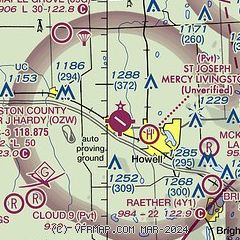
| Sectional chart |
|---|
|
| Airport distance calculator |
|---|
|
|
| Sunrise and sunset |
|---|
|
Times for 26-May-2026
| | Local
(UTC-4) | | Zulu
(UTC) |
|---|
| Morning civil twilight | | 05:32 | | 09:32 |
| Sunrise | | 06:05 | | 10:05 |
| Sunset | | 21:01 | | 01:01 |
| Evening civil twilight | | 21:34 | | 01:34 |
|
| Current date and time |
|---|
| Zulu (UTC) | 27-May-2026 01:20:00 |
|---|
| Local (UTC-4) | 26-May-2026 21:20:00 |
|---|
|
| METAR |
|---|
| KOZW | 270055Z AUTO 26002KT 10SM CLR 23/12 A2999 RMK AO2
|
KTEW
20nm W | 270055Z AUTO 00000KT 10SM CLR 24/11 A2999 RMK AO2 T02440113
|
|
| TAF |
|---|
KFNT
23nm NE | 261724Z 2618/2718 22009KT P6SM BKN250 FM270400 VRB04KT P6SM BKN250 FM270900 03005KT P6SM FEW050 SCT100 BKN200
|
KPTK
25nm E | 261724Z 2618/2718 21008KT P6SM BKN250 FM270400 VRB04KT P6SM BKN250 FM271200 03005KT P6SM FEW050 SCT100 BKN200
|
KLAN
28nm W | 261725Z 2618/2718 23007KT P6SM SCT250 FM270000 VRB04KT P6SM SCT250
|
|
| NOTAMs |
|---|
NOTAMs are issued by the DoD/FAA and will open in a separate window not controlled by AirNav.
|
|


