FAA INFORMATION EFFECTIVE 27 NOVEMBER 2025
Location
| FAA Identifier: | SSF |
| Lat/Long: | 29-20-13.1330N 098-28-15.7600W
29-20.218883N 098-28.262667W
29.3369814,-98.4710444
(estimated) |
| Elevation: | 577.6 ft. / 176.1 m (surveyed) |
| Variation: | 03E (2025) |
| From city: | 6 miles S of SAN ANTONIO, TX |
| Time zone: | UTC -6 (UTC -5 during Daylight Saving Time) |
| Zip code: | 78214 |
Airport Operations
| Airport use: | Open to the public |
| Activation date: | 06/1938 |
| Control tower: | yes |
| ARTCC: | HOUSTON CENTER |
| FSS: | SAN ANGELO FLIGHT SERVICE STATION |
| NOTAMs facility: | SSF (NOTAM-D service available) |
| Attendance: | 0700-2000 |
| Wind indicator: | lighted |
| Segmented circle: | no |
| Lights: | DUSK-DAWN. MIRL RWY 10/28 & 14/32 PRESET MED INTST WHEN ATCT CLSD. |
| Beacon: | white-green (lighted land airport)
Operates sunset to sunrise. |
Airport Communications
| CTAF: | 118.2 |
| UNICOM: | 122.95 |
| ATIS: | 128.8 |
| WX ASOS: | PHONE 210-927-9391 |
| STINSON GROUND: | 121.7 379.9 [0700-2200] |
| STINSON TOWER: | 118.2 379.9 [0700-2200] |
| SAN ANTONIO APPROACH: | 125.7 |
| SAN ANTONIO DEPARTURE: | 125.7 |
| CLEARANCE DELIVERY: | 121.7 ;WHEN SSF TWR CLSD. |
| CRVZA RNAV STAR: | 125.7 |
| DNKIN RNAV STAR: | 125.1 |
| EMERG: | 121.5 243.0 |
| POPPO RNAV STAR: | 125.1 |
| QERVO RNAV STAR: | 127.1 |
| WX ASOS at SAT (12 nm N): | PHONE 210-939-4003 |
| WX AWOS-3 at CVB (20 nm W): | 119.25 (830-931-0232) |
Nearby radio navigation aids
| VOR radial/distance | | VOR name | | Freq | | Var |
|---|
| SSFr340/(4.9) | | STINSON VOR | | 108.40 | | 03E |
| RNDr217/14.6 | | RANDOLPH VORTAC | | 112.30 | | 05E |
| SATr174/18.4 | | SAN ANTONIO VORTAC | | 116.80 | | 08E |
| NDB name | | Hdg/Dist | | Freq | | Var | | ID |
|---|
| DEVINE | | 057/27.3 | | 359 | | 07E | | HHH | .... .... .... |
Airport Services
| Fuel available: | 100LL JET-A |
| Parking: | hangars and tiedowns |
| Airframe service: | MAJOR |
| Powerplant service: | MAJOR |
| Bottled oxygen: | NONE |
| Bulk oxygen: | NONE |
Runway Information
Runway 10/28
| Dimensions: | 5000 x 100 ft. / 1524 x 30 m |
| Surface: | asphalt, in good condition |
| Weight bearing capacity: | | Single wheel: | 30.0 | | Double wheel: | 75.0 |
|
| Runway edge lights: | medium intensity |
| RUNWAY 10 | | RUNWAY 28 |
| Latitude: | 29-20.312817N | | 29-20.133833N |
| Longitude: | 098-28.856300W | | 098-27.937158W |
| Elevation: | 577.6 ft. | | 565.1 ft. |
| Traffic pattern: | left | | left |
| Runway heading: | 100 magnetic, 103 true | | 280 magnetic, 283 true |
| Displaced threshold: | 450 ft. | | no |
| Declared distances: | TORA:5000 TODA:5000 ASDA:5000 LDA:4550 | | TORA:5000 TODA:5000 ASDA:4677 LDA:4677 |
| Markings: | nonprecision, in good condition | | nonprecision, in good condition |
| Visual slope indicator: | 4-light PAPI on left (3.00 degrees glide path) | | 4-light PAPI on left (3.00 degrees glide path) |
| Runway end identifier lights: | yes | | yes |
| Touchdown point: | yes, no lights | | yes, no lights |
| Obstructions: | 29 ft. trees, lighted, 205 ft. from runway, 25 ft. left of centerline
7 FT FENCE, 0 FT DSTC, 167 FT R; 15 FT RD O FT DSTC. | | 16 ft. pole, 318 ft. from runway, 250 ft. right of centerline, 7:1 slope to clear |
Runway 14/32
| Dimensions: | 4128 x 100 ft. / 1258 x 30 m |
| Surface: | asphalt, in good condition |
| Weight bearing capacity: | | Single wheel: | 12.0 | | Double wheel: | 20.0 |
|
| Runway edge lights: | medium intensity |
| RUNWAY 14 | | RUNWAY 32 |
| Latitude: | 29-20.493658N | | 29-19.933325N |
| Longitude: | 098-28.321237W | | 098-27.879370W |
| Elevation: | 572.0 ft. | | 552.9 ft. |
| Traffic pattern: | left | | left |
| Runway heading: | 142 magnetic, 145 true | | 322 magnetic, 325 true |
| Displaced threshold: | 583 ft. | | 372 ft. |
| Declared distances: | TORA:4128 TODA:4128 ASDA:3881 LDA:3297 | | TORA:4128 TODA:4128 ASDA:3902 LDA:3530 |
| Markings: | nonprecision, in good condition | | nonprecision, in good condition |
| Visual slope indicator: | 2-light PAPI on right (3.00 degrees glide path) | | 4-light PAPI on left (3.00 degrees glide path) |
| Runway end identifier lights: | yes | | yes |
| Touchdown point: | yes, no lights | | yes, no lights |
| Obstructions: | 35 ft. trees, 201 ft. from runway
7 FT FENCE 21 FT DSTC. 14 FT RD, 35 FT DSTC ACRS APCH.. | | 25 ft. trees, 201 ft. from runway
6 FT FENCE 0 FT DSTC;15 FT RD 20 FT DSTC, 120 FT L |
Airport Ownership and Management from official FAA records
| Ownership: | Publicly-owned |
| Owner: | CITY OF SAN ANTONIO
8535 MISSION RD
SAN ANTONIO, TX 78214
Phone 210-207-1800 |
| Manager: | MORRIS MARTIN
8535 MISSION RD
SAN ANTONIO, TX 78214
Phone 210-207-1800 |
Additional Remarks
| - | NUMEROUS ACFT OPERATING AT OR ABOVE 2500 FT MSL IN THE STINSON ARPT TFC AREA UNDER THE CTL OF SAN ANTONIO APCH. |
| - | PAEW ADJ ALL TWYS & RAMP AREAS MON-FRI 0700-1759. |
| - | FOR CD WHEN ATCT IS CLSD CTC SAT APCH AT 210-805-5516. |
Instrument Procedures
NOTE: All procedures below are presented as PDF files. If you need a reader for these files, you should download the free Adobe Reader.NOT FOR NAVIGATION. Please procure official charts for flight.
FAA instrument procedures published for use from 27 November 2025 at 0901Z to 25 December 2025 at 0900Z.
STARs - Standard Terminal Arrivals |
|---|
| CENTERPOINT THREE | |
download (262KB) |
| CRVZA TWO (RNAV) **NEW** | |
2 pages:
[1] [2] (298KB) |
| CRVZA TWO (RNAV), CONT.2 **NEW** | |
download (204KB) |
| DNKIN TWO (RNAV) **NEW** | |
2 pages:
[1] [2] (439KB) |
| LEMIG TWO | |
download (203KB) |
| MARCS TWO | |
2 pages:
[1] [2] (424KB) |
| POPPO TWO (RNAV) **NEW** | |
2 pages:
[1] [2] (311KB) |
| POPPO TWO (RNAV), CONT.2 **NEW** | |
download (236KB) |
| QERVO THREE (RNAV) **NEW** | |
2 pages:
[1] [2] (386KB) |
| QERVO THREE (RNAV), CONT.2 **NEW** | |
download (272KB) |
| STONEWALL TWO | |
download (220KB) |
IAPs - Instrument Approach Procedures |
|---|
| RNAV (GPS) RWY 28 **CHANGED** | |
download (208KB) |
| RNAV (GPS) RWY 32 **CHANGED** | |
download (225KB) |
| VOR RWY 32 **CHANGED** | |
download (183KB) |
| NOTE: Special Alternate Minimums apply | |
download (141KB) |
Departure Procedures |
|---|
| ALAMO FIVE | |
2 pages:
[1] [2] (380KB) |
| ALISS SEVEN (RNAV) | |
download (215KB) |
| BOWIE EIGHT | |
2 pages:
[1] [2] (344KB) |
| LEJON FIVE | |
download (223KB) |
| SLENA TWO (RNAV) | |
download (218KB) |
| SNIDR TWO (RNAV) | |
download (288KB) |
| TJANO TWO (RNAV) | |
download (229KB) |
| YODUH TWO (RNAV) | |
download (249KB) |
| NOTE: Special Take-Off Minimums/Departure Procedures apply | |
download (312KB) |
Other nearby airports with instrument procedures:
KSKF - Kelly Field Airport (6 nm NW)
KSAT - San Antonio International Airport (12 nm N)
KRND - Randolph Air Force Base (15 nm NE)
KCVB - Castroville Municipal Airport (20 nm W)
KPEZ - Pleasanton Municipal Airport (23 nm S)
|
|

Road maps at:
MapQuest
Bing
Google
| Aerial photo |
|---|
WARNING: Photo may not be current or correct
 Taken in March 2010
Do you have a better or more recent aerial photo of Stinson Municipal Airport that you would like to share? If so, please send us your photo.
|
| Sectional chart |
|---|
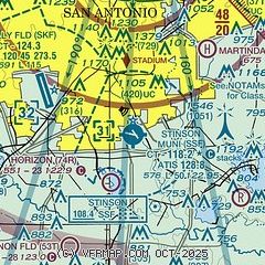
|
CAUTION: Diagram may not be current
 Download PDF
of official airport diagram from the FAA
| Airport distance calculator |
|---|
|
|
| Sunrise and sunset |
|---|
|
Times for 04-Dec-2025
| | Local
(UTC-6) | | Zulu
(UTC) |
|---|
| Morning civil twilight | | 06:48 | | 12:48 |
| Sunrise | | 07:14 | | 13:14 |
| Sunset | | 17:34 | | 23:34 |
| Evening civil twilight | | 18:00 | | 00:00 |
|
| Current date and time |
|---|
| Zulu (UTC) | 04-Dec-2025 15:51:26 |
|---|
| Local (UTC-6) | 04-Dec-2025 09:51:26 |
|---|
|
| METAR |
|---|
| KSSF | 041453Z 03008G23KT 5SM BR OVC008 12/11 A3009 RMK AO2 DZE53 SLP190 P0000 60002 T01170106 53034
|
KSKF
5nm W | 041535Z AUTO 02012KT 10SM BKN014 BKN019 OVC025 12/09 A3010 RMK AO2 SLP192 $
|
KSAT
12nm N | 041451Z 01010G19KT 10SM BKN011 OVC025 11/09 A3011 RMK AO2 RAE37 SLP186 SHRA DSNT NW-NE P0000 60001 T01110094 53032 $
|
KRND
15nm NE | 041540Z 01013G22KT 10SM BKN013 OVC027 10/07 A3015 RMK AO2A CIG 014V028 CIG 012 RWY15R SLP209
|
KCVB
20nm W | 041535Z AUTO 02006G20KT 10SM OVC014 11/10 A3014 RMK AO2
|
|
| TAF |
|---|
| KSSF | 041138Z 0412/0512 03006KT 3SM BR VCSH OVC005 TEMPO 0412/0413 1SM -DZ BR OVC003 FM041400 01013KT 5SM -DZ BR OVC008 FM041700 01014KT P6SM OVC015 FM042300 01008KT P6SM SCT030 OVC120 FM050300 02005KT P6SM OVC120
|
KSKF
5nm W | 041245Z 0412/0516 03012G18KT 8000 -DZ BR OVC005 QNH2995INS TEMPO 0413/0416 4800 -DZ BR OVC007 BECMG 0415/0416 02015G25KT 6000 -RA BR OVC015 520005 QNH3011INS BECMG 0422/0423 02012G18KT 9000 BR VCSH OVC025 510005 QNH3015INS BECMG 0503/0504 02009KT 9999 -RA OVC035 QNH3016INS TX15/0423Z TN07/0510Z
|
KSAT
12nm N | 041138Z 0412/0518 04007KT 3SM -DZ BR VCSH OVC003 TEMPO 0412/0413 1SM -DZ BR OVC002 FM041300 02013KT 5SM -RADZ BR OVC009 FM041700 36014KT P6SM OVC015 FM042000 36014KT P6SM OVC030 FM042300 36008KT P6SM SCT030 OVC120 FM050300 02005KT P6SM OVC120 FM051200 00000KT P6SM OVC050 PROB30 0512/0518 -SHRA
|
KRND
15nm NE | 041334Z 0413/0517 01012G22KT 8000 -DZ BR OVC007 QNH3008INS TEMPO 0413/0415 3200 -DZ BR SCT007 BKN011 OVC018 BECMG 0414/0415 01012G25KT 8000 -DZ BR OVC010 QNH3009INS TEMPO 0415/0417 FEW007 SCT011 OVC018 BECMG 0417/0418 36015G25KT 9999 VCSH OVC015 QNH3011INS BECMG 0422/0423 36012G20KT 9999 NSW OVC030 QNH3014INS BECMG 0511/0512 35007KT 3200 -RA BR BKN004 QNH3014INS BECMG 0515/0516 VRB05KT 4800 BR -RA BR BKN007 QNH3011INS TX13/0419Z TN11/0412Z
|
|
| NOTAMs |
|---|
NOTAMs are issued by the DoD/FAA and will open in a separate window not controlled by AirNav.
|
|


