FAA INFORMATION EFFECTIVE 25 DECEMBER 2025
Location
| FAA Identifier: | WHP |
| Lat/Long: | 34-15-33.5710N 118-24-48.3590W
34-15.559517N 118-24.805983W
34.2593253,-118.4134331
(estimated) |
| Elevation: | 1003 ft. / 306 m (estimated) |
| Variation: | 14E (1990) |
| From city: | 1 mile E of LOS ANGELES, CA |
| Time zone: | UTC -8 (UTC -7 during Daylight Saving Time) |
| Zip code: | 91331 |
Airport Operations
| Airport use: | Open to the public |
| Activation date: | 06/1945 |
| Control tower: | yes |
| ARTCC: | LOS ANGELES CENTER |
| FSS: | HAWTHORNE FLIGHT SERVICE STATION |
| NOTAMs facility: | WHP (NOTAM-D service available) |
| Attendance: | CONTINUOUS |
| Wind indicator: | lighted |
| Segmented circle: | yes |
| Lights: | WHEN ATCT CLSD, ARPT LGT OPRS CONSLY. |
| Beacon: | white-green (lighted land airport)
Operates sunset to sunrise. |
Airport Communications
| CTAF: | 135.0 |
| UNICOM: | 122.95 |
| ATIS: | 132.1 |
| WX AWOS-3PT: | 132.1 (818-899-9820) |
| WHITEMAN GROUND: | 125.0 [0800-2000] |
| WHITEMAN TOWER: | 135.0 [0800-2000] |
| SOCAL APPROACH: | 120.4 ;VNY 280-BUR 050, NORTH 134.2 ;160-280 VNY, WEST |
| SOCAL DEPARTURE: | 120.4 ;VNY 280-BUR 050, NORTH 134.2 ;160-280 VNY, WEST |
| CLASS C: | 120.4 ;VNY 280-BUR 050 134.2 ;160-280 VNY |
| IC: | 120.4 ;VNY 280-BUR 050, NORTH 134.2 ;160-280 VNY, WEST |
| WX ASOS at BUR (4 nm SE): | PHONE 818-841-1384 |
| WX ASOS at VNY (5 nm SW): | PHONE 818-464-9794 |
| WX ASOS at SMO (15 nm S): | PHONE 310-392-6453 |
| WX ASOS at LAX (19 nm S): | PHONE 310-602-6051 |
- WHITEMAN AIRPORT ALTIMETER SETTING NOT AVAILABLE.
Nearby radio navigation aids
| VOR radial/distance | | VOR name | | Freq | | Var |
|---|
| VNYr046/4.4 | | VAN NUYS VOR/DME | | 113.10 | | 15E |
| SMOr353/15.1 | | SANTA MONICA VOR/DME | | 110.80 | | 15E |
| LAXr348/19.6 | | LOS ANGELES VORTAC | | 113.60 | | 15E |
| FIMr089/23.9 | | FILLMORE VORTAC | | 112.50 | | 15E |
| LHSr147/26.7 | | LAKE HUGHES VORTAC | | 114.35 | | 15E |
| PMDr203/28.2 | | PALMDALE VORTAC | | 115.55 | | 15E |
| VTUr060/32.7 | | VENTURA VOR/DME | | 116.55 | | 15E |
| POMr274/32.9 | | POMONA VORTAC | | 110.40 | | 15E |
| SLIr313/33.7 | | SEAL BEACH VORTAC | | 115.70 | | 15E |
| CMAr070/33.9 | | CAMARILLO VOR/DME | | 115.80 | | 15E |
| GMNr130/39.5 | | GORMAN VORTAC | | 116.10 | | 16E |
Airport Services
| Fuel available: | 100LL JET-A |
| Parking: | tiedowns |
| Airframe service: | MAJOR |
| Powerplant service: | MAJOR |
| Bottled oxygen: | HIGH |
| Bulk oxygen: | HIGH |
Runway Information
Runway 12/30
| Dimensions: | 4120 x 75 ft. / 1256 x 23 m |
| Surface: | asphalt, in good condition |
| Weight bearing capacity: | |
| Runway edge lights: | medium intensity |
| RUNWAY 12 | | RUNWAY 30 |
| Latitude: | 34-15.811667N | | 34-15.301000N |
| Longitude: | 118-25.075500W | | 118-24.535833W |
| Elevation: | 1003.0 ft. | | 960.0 ft. |
| Traffic pattern: | left | | right |
| Runway heading: | 125 magnetic, 139 true | | 305 magnetic, 319 true |
| Displaced threshold: | 729 ft. | | 478 ft. |
| Declared distances: | TORA:3442 TODA:4120 ASDA:3910 LDA:3181 | | TORA:3191 TODA:4120 ASDA:3940 LDA:3462 |
| Markings: | basic, in good condition | | basic, in good condition |
| Visual slope indicator: | 2-light PAPI on right (3.80 degrees glide path)
PAPI DOES NOT PRVD OBSTN CLNC BYD 5 NM FROM THLD. | | 2-light PAPI on left (3.80 degrees glide path) |
| Runway end identifier lights: | yes | | yes |
| Touchdown point: | yes, no lights | | yes, no lights |
| Obstructions: | 30 ft. pline, 200 ft. from runway, 45 ft. right of centerline
HAS + 6 FT FENCE 60 FT FM EOR AND ROAD 70 FT FM EOR 125 FT L TO R; +12 FT BLDG 135-200 FM FM EOR 20-50 FT L; +24 FT LIGHT STANDARD 140 FT FM EOR 45 FT R. | | 30 ft. pline, lighted, 200 ft. from runway, 10 ft. right of centerline
HAS 35 FT TREES 50 FT FM EOR 110 FT R; +6 FT FENCE 30 FT FM EOR 125 FT L TO R; ROAD 80 FT FM EOR 125 FT L TO R; +30 FT PLINES 160 FT FM EOR 125 FT L TO R; + 20 FT LIGHT 75 FT FM EOR 20 FT L. |
Airport Ownership and Management from official FAA records
| Ownership: | Publicly-owned |
| Owner: | LOS ANGELES CO
P.O. BOX 1460
ALHAMBRA, CA 91802-1460
Phone 626-300-4600
LA COUNTY CTC: PAUL MASELBAS, 626-300-4600 X4615. |
| Manager: | ALVARO ESCOBEDO
10000 AIRPARK WAY
PACOIMA, CA 91331
Phone 818-896-5271
AIR TRAFFIC MGR: 818-896-5555. |
Additional Remarks
| E125 | INCLUDES 3 AMPHIBIANS. |
| - | HELICOPTER OPNS 2500' MSL (1500' AGL) AND BELOW. |
| - | FOR CD WHEN ATCT CLSD CTC SOCAL APCH AT 800-448-3724. |
| - | VOLUNTARY CURFEW IN EFCT. ALL ACFT OPRS, EXCP FOR FLTS RELATED TO EMERG, LIFESAVING, FIREFIGHTING, LAW ENFORCEMENT, GOVT AGENCIES, AND SVCS TO THE PUBLIC SUCH AS NEWS MEDIA, ARE REQD TO AVOID CONDUCTING ACFT ARRS AND DEPS BTN 2200 AND 0600 DAILY. |
| - | POWER LINES SW OF RY PENETRATE 7:1 TRANSITIONAL SFC. |
| - | BIRDS ON AND INVOF ARPT. |
| - | AIRPORT CLOSED TO HELICOPTER TRAINING / PATTERN OPERATIONS 2000-0800. |
| - | DIRT INFIELD AREAS. HELICOPTERS ADVISED TO USE CARE TO PREVENT BLASTING DIRT AND DEBRIS ONTO MOVEMENT AREAS. |
Instrument Procedures
NOTE: All procedures below are presented as PDF files. If you need a reader for these files, you should download the free Adobe Reader.NOT FOR NAVIGATION. Please procure official charts for flight.
FAA instrument procedures published for use from 25 December 2025 at 0901z to 22 January 2026 at 0900z.
IAPs - Instrument Approach Procedures |
|---|
| RNAV (GPS) RWY 12 | |
download (515KB) |
| VOR-A | |
download (426KB) |
| NOTE: Special Alternate Minimums apply | |
download (37KB) |
|
|---|
| WHITEMAN ONE (OBSTACLE) | |
download (263KB) |
| NOTE: Special Take-Off Minimums/Departure Procedures apply | |
download (190KB) |
Other nearby airports with instrument procedures:
KBUR - Bob Hope Airport (4 nm SE)
KVNY - Van Nuys Airport (5 nm SW)
KSMO - Santa Monica Municipal Airport (15 nm S)
KLAX - Los Angeles International Airport (19 nm S)
KHHR - Jack Northrop Field/Hawthorne Municipal Airport (21 nm S)
|
|

Road maps at:
MapQuest
Bing
Google
| Aerial photo |
|---|
WARNING: Photo may not be current or correct
 Photo by Fred Emmert AirViews.com
Photo taken 14-Mar-2015
looking north.
Photo by Fred Emmert AirViews.com
Photo taken 14-Mar-2015
looking north.
Do you have a better or more recent aerial photo of Whiteman Airport that you would like to share? If so, please send us your photo.
|
| Sectional chart |
|---|
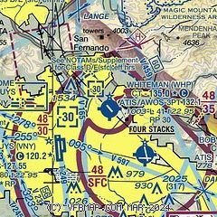
|
 Download PDF
of official airport diagram from the FAA
| Airport distance calculator |
|---|
|
|
| Sunrise and sunset |
|---|
|
Times for 02-Jan-2026
| | Local
(UTC-8) | | Zulu
(UTC) |
|---|
| Morning civil twilight | | 06:33 | | 14:33 |
| Sunrise | | 07:01 | | 15:01 |
| Sunset | | 16:55 | | 00:55 |
| Evening civil twilight | | 17:22 | | 01:22 |
|
| Current date and time |
|---|
| Zulu (UTC) | 02-Jan-2026 14:51:24 |
|---|
| Local (UTC-8) | 02-Jan-2026 06:51:24 |
|---|
|
| METAR |
|---|
| KWHP | 020255Z 00000KT 10SM OVC055 14/13 A3010
|
KBUR
4nm SE | 021353Z 02003KT 10SM OVC050 11/09 A3007 RMK AO2 SLP175 T01060089
|
KVNY
4nm SW | 021351Z AUTO 00000KT 10SM OVC050 09/08 A3006 RMK AO2 SLP177 T00890083
|
KSMO
15nm S | 021351Z AUTO 04003KT 10SM OVC055 12/11 A3006 RMK AO2 SLP179 T01220106
|
KMWS
17nm E | 021420Z 22005G06KT 05/05
|
KLAX
20nm S | 021353Z 05005KT 10SM FEW008 FEW028 BKN050 14/11 A3006 RMK AO2 SLP176 T01390111 $
|
|
| TAF |
|---|
KBUR
4nm SE | 021120Z 0212/0312 VRB03KT 6SM BR SCT025 OVC050 FM022000 15010KT P6SM SCT025 OVC050 FM030700 VRB03KT P6SM SCT015 OVC035
|
KVNY
4nm SW | 021120Z 0212/0312 VRB03KT 6SM BR SCT025 OVC050 FM021900 14010KT P6SM SCT025 OVC050 FM030600 VRB03KT P6SM SCT015 OVC035
|
KSMO
15nm S | 021120Z 0212/0312 VRB03KT 6SM BR SCT025 BKN050 FM021500 08005KT P6SM OVC050 FM022200 13005KT P6SM OVC050 FM030200 VRB03KT P6SM SCT025 OVC050
|
KLAX
20nm S | 021120Z 0212/0318 08004KT 6SM BR SCT015 BKN050 FM021500 08007KT 6SM BR SCT015 BKN050 FM022200 12008KT P6SM FEW025 BKN050 FM030100 16008KT P6SM OVC050 FM030800 10005KT P6SM SCT015 OVC050 FM031500 13008KT 6SM BR BKN025 OVC050 PROB30 0316/0318 -RA BKN015
|
|
| NOTAMs |
|---|
NOTAMs are issued by the DoD/FAA and will open in a separate window not controlled by AirNav.
|
|


