FAA INFORMATION EFFECTIVE 16 APRIL 2026
Location
| FAA Identifier: | HHR |
| Lat/Long: | 33-55-22.3000N 118-20-06.3000W
33-55.371667N 118-20.105000W
33.9228611,-118.3350833
(estimated) |
| Elevation: | 65.9 ft. / 20.1 m (surveyed) |
| Variation: | 14E (1985) |
| From city: | 1 mile E of HAWTHORNE, CA |
| Time zone: | UTC -7 (UTC -8 during Standard Time) |
| Zip code: | 90250 |
Airport Operations
| Airport use: | Open to the public |
| Activation date: | 10/1942 |
| Control tower: | yes |
| ARTCC: | LOS ANGELES CENTER |
| FSS: | HAWTHORNE FLIGHT SERVICE STATION |
| NOTAMs facility: | HHR (NOTAM-D service available) |
| Attendance: | M-F 0600-2200, ALL SAT 0600-2200, ALL SUN 0600-2200 |
| Pattern altitude: | 1165.9 ft. MSL
TPA FOR TURBINE & HIGH PER ACFT 1600 (1534), LGT ACFT 1100 (1034), HELS 700 (634). |
| Wind indicator: | lighted |
| Segmented circle: | yes |
| Lights: | WHEN ATCT CLSD ACTVT MIRL RY 07/25 & ODALS RY 25 - CTAF. |
| Beacon: | white-green (lighted land airport)
Operates sunset to sunrise. |
| Taxiway lights: | N EDGE OF N TWY UNLGTD; WEST 1000' OF SOUTH TWY UNLGTD. |
Airport Communications
| CTAF: | 121.1 |
| ATIS: | 118.4 |
| WX ASOS: | PHONE 310-973-8930 |
| HAWTHORNE GROUND: | 125.1 [0600-2200] |
| HAWTHORNE TOWER: | 121.1 257.8 [0600-2200] |
| SOCAL APPROACH: | 124.3 ;146-245 HHR 124.9 ;069-145 LAX 125.2 ;246-342 LAX 128.5 ;343-068 |
| SOCAL DEPARTURE: | 124.3 |
| EMMLN STAR: | 127.0 |
| IC: | 124.9 ;069-145 LAX |
| IRNMN STAR: | 124.5 |
| RYDRR STAR: | 124.5 |
| WX ASOS at LAX (4 nm W): | PHONE 310-602-6051 |
| WX AWOS-3PT at CPM (5 nm SE): | 127.150 (310-631-3022) |
| WX AWOS-3PT at TOA (7 nm S): | PHONE 310-534-2847 |
| WX ASOS at SMO (8 nm NW): | PHONE 310-309-5134 |
| WX ASOS at LGB (11 nm SE): | PHONE 562-247-0378 |
| WX ASOS at BUR (17 nm N): | PHONE 818-841-1384 |
| WX AWOS-3PT at EMT (18 nm NE): | 118.75 ((626) 444-1107) |
| WX ASOS at FUL (18 nm E): | PHONE 714-870-1372 |
| WX ASOS at VNY (19 nm NW): | PHONE 818-464-9794 |
Nearby radio navigation aids
| VOR radial/distance | | VOR name | | Freq | | Var |
|---|
| LAXr082/4.9 | | LOS ANGELES VORTAC | | 113.60 | | 15E |
| SMOr116/8.0 | | SANTA MONICA VOR/DME | | 110.80 | | 15E |
| SLIr286/16.3 | | SEAL BEACH VORTAC | | 115.70 | | 15E |
| VNYr142/19.6 | | VAN NUYS VOR/DME | | 113.10 | | 15E |
| POMr236/28.8 | | POMONA VORTAC | | 110.40 | | 15E |
| SXCr352/33.1 | | SANTA CATALINA VORTAC | | 114.15 | | 15E |
| ELBr282/33.6 | | EL TORO VOR/DME | | 117.20 | | 14E |
| VTUr093/37.4 | | VENTURA VOR/DME | | 116.55 | | 15E |
| FIMr119/37.6 | | FILLMORE VORTAC | | 112.50 | | 15E |
Airport Services
| Fuel available: | 100LL JET-A
100LL:100LL FUEL AVBL 24 HRS SELF-SERVICE. JET A FUEL AVBL 0500-2200 M-F, 0600-2100 SAT, 0600-2200 SUN; AFTER HRS SVC CALL JET CENTER LOS ANGELES (310) 676-4673 OR HAWTHORNE HANGAR OPERATIONS (310) 644-0400. |
| Parking: | tiedowns |
| Airframe service: | MAJOR |
| Powerplant service: | MAJOR |
| Bottled oxygen: | HIGH |
| Bulk oxygen: | HIGH |
Runway Information
Runway 7/25
| Dimensions: | 4884 x 100 ft. / 1489 x 30 m |
| Surface: | asphalt, in good condition |
| Weight bearing capacity: | | Single wheel: | 30.0 | | Double wheel: | 60.0 | | Double tandem: | 90.0 |
|
| Runway edge lights: | medium intensity |
| RUNWAY 7 | | RUNWAY 25 |
| Latitude: | 33-55.348095N | | 33-55.393648N |
| Longitude: | 118-20.587365W | | 118-19.623055W |
| Elevation: | 65.9 ft. | | 60.8 ft. |
| Traffic pattern: | right | | left |
| Runway heading: | 073 magnetic, 087 true | | 253 magnetic, 267 true |
| Displaced threshold: | 905 ft. | | 460 ft. |
| Declared distances: | TORA:4884 TODA:4884 ASDA:4667 LDA:3762 | | TORA:4884 TODA:4884 ASDA:4654 LDA:4194 |
| Markings: | nonprecision, in fair condition | | nonprecision, in fair condition |
| Visual slope indicator: | 2-box VASI on right (3.25 degrees glide path) | | 4-box VASI on right (3.50 degrees glide path) |
| Approach lights: | | | ODALS: omnidirectional approach lighting system |
| Runway end identifier lights: | no | | no |
| Touchdown point: | yes, no lights | | yes, no lights |
| Instrument approach: | | | LOCALIZER |
| Obstructions: | 13 ft. road, 200 ft. from runway
LOC AT RY END. STREET AT 110 FT FROM RY END 07 +37 FT POLE 100 FT FROM E OR 250 FT RIGHT; +10 FT BLDG 100 FT FROM E OR 200 FT RIGHT. | | 23 ft. pole, lighted, 200 ft. from runway, 100 ft. right of centerline
+8 FT BLAST FENCE LEFT AT 70 FT ON CNTRLN; +23 FT LGT STD AT 110 FT; STREET AT 110 FT FM RY END 25; 500 FT LEFT & RIGHT OF CNTRLN; +6 FT FENCE LEFT AT 105 FT FM EOR 500 FT LEFT & RIGHT OF CNTRLN. |
Airport Ownership and Management from official FAA records
| Ownership: | Publicly-owned |
| Owner: | CITY OF HAWTHORNE
CITY HALL, 4455 W 126 ST.
HAWTHORNE, CA 90250
Phone 310-349-2900 |
| Manager: | GUIDO FERNANDEZ
12101 S.CRENSHAW BLVD, SUITE # 3
HAWTHORNE, CA 90250
Phone 310-349-1637
EMAIL: GFERNANDEZ@CITYOFHAWTHORNE.ORG |
Additional Remarks
| - | TGL, STOP AND GO LDG AND LOW APCH OPNS FOR ALL ACFT INCLG HELS LTD TO 1000-1700 DLY. |
| - | NO PAT OPNS, NO TAXI-BACK OPNS MON-FRI 2200-0800, SAT-SUN 2200-1000. |
| - | RWY 25 RUNUP SOUTH OF S TWY 900 FT WEST OF AER 25. |
| - | N TWY WEST OF E TWY DESIGNATED NON-MOVEMENT AREA. |
| - | FOR NOISE ABATEMENT INFO CTC ARPT SUPVR (310) 349-1637 OR 1636. |
| - | NO FRMN TKOFS AUTH. |
| - | RWY 25 TOUCH AND GO, STOP AND GO, AND INT TKOFS ARE REQSTD TO BE AIRBORNE BY D TWY. |
| - | HOVER WORK LTD TO N TWY BTN C AND D TWYS. |
| - | ALL PISTON ACFT MUST BE EQUIPPED WITH MUFFLER SYS. |
| - | FOR CD WHEN ATCT CLSD CTC SOCAL APCH AT 800-448-3724. |
| - | NO FLD COND NOTAMS AVBL 2100-0500. |
| - | OBSTN PT 77: HNGRS, PLINES, BLDG-ANT ON RWY 07; POLES & TRML ON RWY 25. |
| - | BE ALERT TO 8 FT BLAST FENCE AER 25. |
| - | NUMEROUS FLOCKS OF BIRDS ON AND INVOF ARPT. |
Instrument Procedures
NOTE: All procedures below are presented as PDF files. If you need a reader for these files, you should download the free Adobe Reader.NOT FOR NAVIGATION. Please procure official charts for flight.
FAA instrument procedures published for use from 16 April 2026 at 0901Z to 14 May 2026 at 0900Z.
STARs - Standard Terminal Arrivals |
|---|
| EMMLN TWO | |
2 pages:
[1] [2] (412KB) |
| IRNMN TWO (RNAV) | |
2 pages:
[1] [2] (401KB) |
| RYDRR TWO (RNAV) | |
2 pages:
[1] [2] (408KB) |
IAPs - Instrument Approach Procedures |
|---|
| RNAV (GPS) RWY 07 | |
download (239KB) |
| RNAV (GPS) RWY 25 | |
download (283KB) |
| LOC RWY 25 | |
download (291KB) |
| VOR RWY 25 | |
download (268KB) |
| NOTE: Special Alternate Minimums apply | |
download (140KB) |
Departure Procedures |
|---|
| SPACX TWO (RNAV) | |
download (199KB) |
| NOTE: Special Take-Off Minimums/Departure Procedures apply | |
download (350KB) |
Other nearby airports with instrument procedures:
KLAX - Los Angeles International Airport (4 nm W)
KTOA - Zamperini Field Airport (7 nm S)
KSMO - Santa Monica Municipal Airport (8 nm NW)
KLGB - Long Beach Airport (Daugherty Field) (11 nm SE)
KSLI - Los Alamitos Army Airfield (16 nm SE)
KBUR - Bob Hope Airport (17 nm N)
KEMT - San Gabriel Valley Airport (18 nm NE)
KFUL - Fullerton Municipal Airport (18 nm E)
KVNY - Van Nuys Airport (19 nm NW)
|
|

Road maps at:
MapQuest
Bing
Google
| Aerial photo |
|---|
WARNING: Photo may not be current or correct
 Photo by focalflight.com
Photo taken 28-Apr-2015
looking northeast.
Photo by focalflight.com
Photo taken 28-Apr-2015
looking northeast.
Do you have a better or more recent aerial photo of Jack Northrop Field/Hawthorne Municipal Airport that you would like to share? If so, please send us your photo.
|
| Sectional chart |
|---|
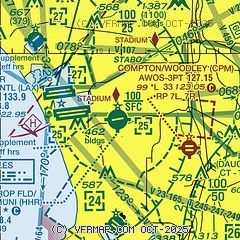
|
CAUTION: Diagram may not be current
 Download PDF
of official airport diagram from the FAA
| Airport distance calculator |
|---|
|
|
| Sunrise and sunset |
|---|
|
Times for 06-May-2026
| | Local
(UTC-7) | | Zulu
(UTC) |
|---|
| Morning civil twilight | | 05:33 | | 12:33 |
| Sunrise | | 06:00 | | 13:00 |
| Sunset | | 19:40 | | 02:40 |
| Evening civil twilight | | 20:07 | | 03:07 |
|
| Current date and time |
|---|
| Zulu (UTC) | 06-May-2026 12:32:28 |
|---|
| Local (UTC-7) | 06-May-2026 05:32:28 |
|---|
|
| METAR |
|---|
| KHHR | 061153Z AUTO 00000KT 10SM CLR 14/11 A3005 RMK AO2 SLP174 T01390106 10161 20139 55003 $
|
KLAX
2nm W | 061153Z VRB03KT 10SM FEW016 FEW025 14/11 A3004 RMK AO2 SLP172 T01390106 10156 20128 55003
|
KSMO
8nm NW | 061151Z AUTO 00000KT 10SM CLR 12/09 A3004 RMK AO2 SLP173 T01220094 10150 20122 55003
|
KTOA
8nm S | 060250Z 24004KT 10SM SCT070 16/11 A2998
|
KLGB
11nm SE | 061153Z 12004KT 10SM CLR 13/12 A3004 RMK AO2 SLP171 T01330117 10161 20133 55000
|
KBUR
17nm N | 061153Z 00000KT 10SM CLR 11/07 A3005 RMK AO2 SLP167 T01110067 10144 20111 55001
|
KSLI
18nm SE | 061155Z AUTO 00000KT 10SM CLR 13/10 A3001 RMK AO2 SLP165 T01320102 10155 20131 55002
|
KFUL
18nm E | 061153Z AUTO 08004KT 10SM CLR 13/11 A3004 RMK AO2 SLP171 T01330106 10156 20133 55001
|
KEMT
18nm NE | 060145Z 23005KT 10SM BKN055 18/07 A2996
|
KVNY
19nm NW | 061151Z 00000KT 10SM CLR 10/08 A3004 RMK AO2 SLP168 T01000078 10133 20100 55002 $
|
|
| TAF |
|---|
KLAX
2nm W | 061141Z 0612/0718 06004KT P6SM SKC FM061800 25006KT P6SM SKC FM062000 26012KT P6SM SKC FM070400 27005KT P6SM SKC FM071200 25004KT 4SM BR BKN006 FM071700 25005KT 5SM HZ SKC
|
KSMO
8nm NW | 061141Z 0612/0712 VRB03KT P6SM SKC FM061800 20005KT P6SM SKC FM062000 23008KT P6SM SKC FM070200 VRB03KT P6SM SKC
|
KLGB
11nm SE | 061141Z 0612/0712 VRB03KT P6SM SKC FM062000 19008KT P6SM SCT025 FM062300 30010KT P6SM SKC FM070300 25004KT P6SM SKC FM071100 25004KT 4SM BR BKN006
|
KBUR
17nm N | 061141Z 0612/0712 VRB03KT P6SM SKC FM062100 18008KT P6SM SKC FM070200 18005KT P6SM SKC
|
KSLI
18nm SE | 060500Z 0605/0711 VRB06KT 9999 FEW060 QNH2999INS BECMG 0608/0609 VRB06KT 9000 BR SCT015 BKN020 QNH3003INS BECMG 0612/0613 VRB06KT 9999 NSW FEW020 SCT040 QNH3007INS TX21/0623Z TN14/0613Z
|
KVNY
19nm NW | 061141Z 0612/0712 VRB03KT P6SM SKC FM062100 18008KT P6SM SKC FM062300 13005KT P6SM SKC
|
|
| NOTAMs |
|---|
NOTAMs are issued by the DoD/FAA and will open in a separate window not controlled by AirNav.
|
|


