FAA INFORMATION EFFECTIVE 04 SEPTEMBER 2025
Location
| FAA Identifier: | L52 |
| Lat/Long: | 35-06-05.5050N 120-37-20.3350W
35-06.091750N 120-37.338917W
35.1015292,-120.6223153
(estimated) |
| Elevation: | 14 ft. / 4.3 m (surveyed) |
| Variation: | 15E (1985) |
| From city: | 1 mile W of OCEANO, CA
(ARPT LCTD 2 SM S OF PISMO BEACH.) |
| Time zone: | UTC -7 (UTC -8 during Standard Time) |
| Zip code: | 93445 |
Airport Operations
| Airport use: | Open to the public |
| Activation date: | 10/1947 |
| Control tower: | no |
| ARTCC: | LOS ANGELES CENTER |
| FSS: | HAWTHORNE FLIGHT SERVICE STATION |
| NOTAMs facility: | HHR (NOTAM-D service available) |
| Attendance: | UNATNDD |
| Pattern altitude: | 1000 ft. MSL |
| Wind indicator: | lighted |
| Segmented circle: | yes |
| Lights: | ACTVT MIRL RWY 11/29 - CTAF. |
| Beacon: | white-green (lighted land airport)
DUSK-DAWN. |
Airport Communications
| CTAF/UNICOM: | 122.7 |
| WX AWOS-3: | 118.375 (805-489-1305) |
| WX ASOS at SBP (8 nm N): | 120.6 (805-547-1260) |
| WX ASOS at SMX (15 nm SE): | 121.15 (209-210-1160) |
Nearby radio navigation aids
| VOR radial/distance | | VOR name | | Freq | | Var |
|---|
| GLJr315/(10.2) | | GUADALUPE VOR | | 113.05 | | 16E |
| MQOr127/11.3 | | MORRO BAY VORTAC | | 112.40 | | 16E |
| PRBr164/34.3 | | PASO ROBLES VORTAC | | 114.30 | | 16E |
| FLWr255/37.2 | | FELLOWS VOR/DME | | 117.50 | | 16E |
Airport Services
| Fuel available: | 100LL
100LL:SELF SVC FUEL AVBL 24 HRS. |
| Parking: | tiedowns |
| Bottled oxygen: | NONE |
| Bulk oxygen: | NONE |
Runway Information
Runway 11/29
| Dimensions: | 2325 x 50 ft. / 709 x 15 m |
| Surface: | asphalt, in fair condition |
| Weight bearing capacity: | |
| Runway edge lights: | medium intensity |
| RUNWAY 11 | | RUNWAY 29 |
| Latitude: | 35-06.196167N | | 35-05.987333N |
| Longitude: | 120-37.534333W | | 120-37.143500W |
| Elevation: | 12.0 ft. | | 16.5 ft. |
| Traffic pattern: | right | | left |
| Runway heading: | 109 magnetic, 124 true | | 289 magnetic, 304 true |
| Markings: | basic, in fair condition | | basic, in fair condition |
| Runway end identifier lights: | | | no |
| Touchdown point: | yes, no lights | | yes, no lights |
| Obstructions: | 8 ft. brush, 380 ft. from runway, 80 ft. right of centerline, 22:1 slope to clear | | 15 ft. trees, 506 ft. from runway, 53 ft. left of centerline, 20:1 slope to clear |
Airport Ownership and Management from official FAA records
| Ownership: | Publicly-owned |
| Owner: | SAN LUIS OBISPO COUNTY
COUNTY GOVT CNTR 460
SAN LUIS OBISPO, CA 93408
Phone 805-781-5200
C.A.E. |
| Manager: | COURTNEY JOHNSON
975 AIRPORT DRIVE, SUITE 1
SAN LUIS OBISPO, CA 93401-8417
Phone 805-781-5218
PHONE AT ARPT 805-788-2000 |
Additional Remarks
| - | UNSFCD AREAS SOFT AND UNUSBL. |
| - | RECURRING FLOCKS OF WATERFOWL ON AND INVOF ARPT. |
| - | ULTRALIGHT ACT ON AND INVOF ARPT. |
| - | BE ALERT FOR KITES FLOWN ALONG BEACH 1/2 MILE W OF RWY. |
| - | TAXILANES VERY NRW NR BLDGS & PARKED ACFT. |
| - | EXTREMELY NOISE SENSITIVE ARPT & COMMUNITY; FOR TKOF RWY 29 PILOTS ARE REQD TO MNTN RWY HDG TIL XNG THE SHORELINE. |
| - | TWY LGTS AT EXIT ONLY. |
| - | FOR CD CTC LOS ANGELES ARTCC AT 661-575-2079. |
Instrument Procedures
There are no published instrument procedures at L52.
Some nearby airports with instrument procedures:
KSBP - San Luis Obispo County Regional Airport (8 nm N)
KSMX - Santa Maria Public Airport/Capt G Allan Hancock Field (15 nm SE)
KVBG - Vandenberg Space Force Base (22 nm S)
KLPC - Lompoc Airport (27 nm S)
KPRB - Paso Robles Municipal Airport (34 nm N)
|
|

Road maps at:
MapQuest
Bing
Google
| Aerial photo |
|---|
WARNING: Photo may not be current or correct
 Photo by Mark Stephens
Photo taken 03-May-2021
looking southwest.
Photo by Mark Stephens
Photo taken 03-May-2021
looking southwest.
Do you have a better or more recent aerial photo of Oceano County Airport that you would like to share? If so, please send us your photo.
|
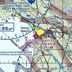
| Sectional chart |
|---|
|
| Airport distance calculator |
|---|
|
|
| Sunrise and sunset |
|---|
|
Times for 27-Sep-2025
| | Local
(UTC-7) | | Zulu
(UTC) |
|---|
| Morning civil twilight | | 06:30 | | 13:30 |
| Sunrise | | 06:55 | | 13:55 |
| Sunset | | 18:52 | | 01:52 |
| Evening civil twilight | | 19:17 | | 02:17 |
|
| Current date and time |
|---|
| Zulu (UTC) | 28-Sep-2025 02:19:19 |
|---|
| Local (UTC-7) | 27-Sep-2025 19:19:19 |
|---|
|
| METAR |
|---|
KSBP
8nm N | 280156Z AUTO 00000KT 10SM OVC014 19/16 A2988 RMK AO2 SLP116 T01890161 $
|
KSMX
15nm SE | 280151Z 29004KT 5SM BR OVC009 18/17 A2988 RMK AO2 SLP119 T01780167 $
|
|
| TAF |
|---|
KSBP
8nm N | 272103Z 2721/2818 23008KT P6SM OVC020 FM280200 VRB03KT P6SM OVC015
|
KSMX
15nm SE | 272124Z 2721/2818 26007KT 6SM HZ OVC015 FM272300 29008KT P6SM BKN025 FM280400 VRB03KT P6SM OVC015 FM280800 VRB03KT 6SM BR OVC008 FM281500 VRB03KT 6SM BR OVC015
|
|
| NOTAMs |
|---|
NOTAMs are issued by the DoD/FAA and will open in a separate window not controlled by AirNav.
|
|


